
Red River Floodway to operate Friday morning

Manitoba Infrastructure plans to operate the Red River Floodway on Friday morning, reducing the risk of flooding for low-lying Winnipeg properties.
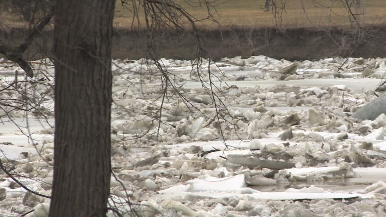
Earlier Thursday, ice on the Red River led the City of Winnipeg to begin preparing for a weekend flood crest that would be high enough to require the placement of sandbag dikes around up to 50 low-lying properties.
Enough of that ice has moved off the Red River to allow the province to use the floodway to reduce river levels within the city. The floodway control structure will begin operating at 10 a.m. on Friday morning, Manitoba Infrastructure said in a release.
The Red River was expected to crest in Winnipeg early Sunday morning. A flood warning has been issued for the lower Red River due to ice jams north of Winnipeg near Selkirk.
"Water levels are significantly increasing across much of southern Manitoba, particularly on the Red River and Assiniboine River tributaries," stated a flood bulletin issued Thursday afternoon.
The city is still preparing to deliver up to 75,000 sandbags to up to 50 properties, if the need remains.
"We're in action mode today and we're confident that we'll be able to get the sandbags out and get the dikes built," said Ken Allen, a spokesman for Winnipeg's public works department.
Under open-water conditions, the Red River is expected to peak at 19.1 feet above normal winter ice levels at James Avenue. That level, unofficially considered a moderate flood, is about 10 feet above the level of the Assiniboine riverwalk and is not high enough to threaten properties.
Ice jams could have led the Red to peak at 20.8 feet James, which is considered a major flood and would require some precautionary deployment of sandbags. That level is similar to the crest of the 2011 spring flood.
At 6 p.m., the Red River stood at 16.9 feet James.
Flood protection is a "dynamic situation," said Chris Carroll, manager of wastewater services for the city.
"It's weather driven, it's ice driven, it's driven by how much water is absorbed into the soil."
Property owners being notified
Notifications to sandbag were being hand delivered by city staff on Thursday. As of early afternoon, city officials had notified owners of a handful of properties on Cloutier Drive, Christie Road and Kingston Row, among other low-lying streets.
If you are not notified, your property is not at risk of flooding, city officials said.
For privacy reasons, the city will not publicly release a list of properties potentially at risk for flooding.
At-risk homes are identified by a city software program called the flood manual, which identifies locations by combining factors such as elevation, the flows on the Red, Assiniboine and Seine rivers, weather forecasts and ice conditions.
The number of properties at risk could rise or drop to zero, depending on weather and ice conditions, the city said.
As the ice on the Red River moves north of the city, Highway 204 was closed just outside Selkirk by midday Thursday due to overland flooding.
Highway 342 from Cypress River to one kilometre south of the junction with Highway 253 was also closed due to water on the road.
Flood watches are in effect for the Fisher River and Pipestone Creek due to the potential for ice jams.
The province says it has put flood-fighting equipment, such as pumps, steamers and backhoes, in areas where problems may arise, mostly in the southwest region.
As well, provincial officials are in contact with municipal emergency co-ordinators.
The worst flooding in the province is expected along the Souris River in southwestern Manitoba and along the lower Assiniboine River, downstream from the confluence of the Souris and Assiniboine, near Wawanesa.
