
Amid fears of more flooding, Armed Forces send troops to aid B.C.


UPDATES: Help arrives as threat of flooding rises again in B.C.
Hundreds of troops from the Canadian Armed Forces will soon be in B.C. to help with flood relief efforts, just as provincial officials are warning the weekend could bring another surge of water.
More than 140 members were deployed from the Edmonton area Wednesday evening, and a second deployment of 175 personnel is expected to arrive on Friday, according to an Armed Forces spokesperson.
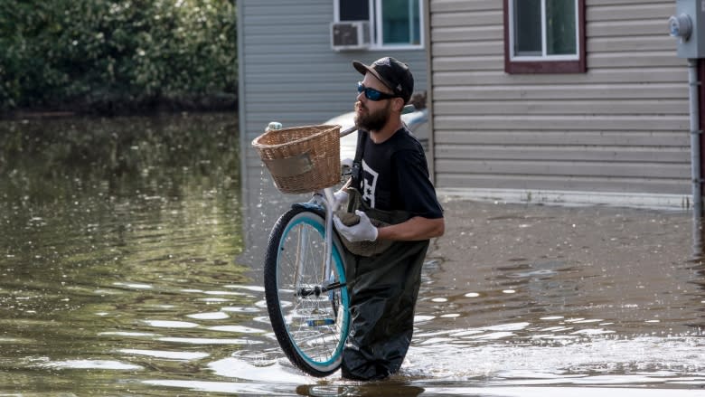
Across the province more than 4,500 people remain under evacuation orders and another 7,100 are on alert, meaning the residents must be ready to leave at a moment's notice. Thirty-six local states of emergency have been declared and 13 First Nations band councils have issued resolutions in response to emergency situations.
Public Safety Minister Ralph Goodale said Ottawa responded "almost immediately" to a request for help from B.C.
"Their current resources are very tired. These people have been on the front lines for days and they need some relief," Goodale told reporters.
Already this week, forest firefighters and the Salvation Army have been deployed to the region to provide assistance, sandbagging and hot meals for volunteers.
Troops to sandbag, aid evacuations
The first troops have already arrived in Vernon and Victoria to work with local and provincial emergency operations teams. Goodale said they'll help with evacuations, sandbagging and reinforcing dams and dikes.
Earlier in the morning B.C. Public Safety Minister Mike Farnworth said the federal government has agreed to send more troops if needed. The troops will stay long enough to get through the next round of flooding, he said.
Coming rain a concern
For communities near Okanagan Lake, there are fears the water could reach or even exceed the historic levels seen during the 2017 floods.
"Because of this hot weather … the water is coming into Okanagan Lake even faster than it did last year," said Shaun Reimer, section head for public safety and protection with the Ministry of Forests.
What happens next is entirely dependent on the weather.
"If we get a substantial amount of rain — we're very vulnerable to the rain right now — that would be a setback," he said.
On Thursday afternoon, a new evacuation order was issued for nine properties in the southern Okanagan community of Olalla.
"Last year, the first two trailers they got it pretty hard. The rest of them weren't so bad. This year it's gone way farther up," said one resident of Olalla, Kimberley Harry.
"It's just devastating to see so many people displaced and have all their belongings gone and some of them [have] no insurance."
As temperatures heat up Thursday afternoon, thunderstorms with up to 40 millimetres of rain are possible throughout the B.C. Interior, said CBC meteorologist Johanna Wagstaffe.
In the morning, officials warned Keromeos Creek was already breaching its banks near Highway 3 between Keremeos and Cawston and that RCMP may soon close the route.
David Campbell, head of the River Forecast Centre, said long-weekend travellers should not attempt to drive through floodwaters and they should exercise "extreme caution" around rivers and streams across the province.
"The banks can be unstable, and waters swift," he said.
Officials in the Lower Mainland are also keeping a close eye on water levels in the Fraser River, including the river gauges at Hope and Mission.
Already evacuation orders and alerts have been issued for several small communities in the Fraser Valley east of Vancouver, including a new evacuation order for five properties on Harrison Bay issued on Wednesday evening.
Farnworth blamed the heavy flooding this year on a combination of factors, including warm weather, heavy snowpacks in the mountains and last year's forest fires.
"What we are seeing this year is different than previous years. We are seeing a very fast snowmelt. In some regions it has been over 230 per cent normal snowpack — that's significant."
Previous forest fires made conditions worse in many areas because the water is unable to penetrate a crust on the ground left by the hot fires, he said.
Much of the snow at lower elevations has melted in recent weeks, according to the River Forecast Centre, with the remaining flooding threat coming from the mid- to high-elevation snowpack.
That means the flood risks from snow melt are expected to last another one to two weeks. Future risks of flooding beyond that period will largely be associated with heavy rainfall events.
Schools closed as rivers rise
Meanwhile, elementary and secondary students across the Boundary school district of south-central B.C. won't be in class Thursday as that area braces for another round of flooding.
School District 51 says its 10 schools and the development centre will be closed. The district advises parents and students to check online for further updates as they prepare to return from the Victoria Day long weekend.
- Check the B.C. River Forecast Centre predictions.
- Check the latest flood warnings and advisories.
- Check the latest evacuation alerts and warnings.
- Check the latest road closures.
"Due to the potential repeat flooding and road closures, all schools will be closed and school buses will not be running in School District No. 51 on Thursday," said a statement on the district website.
