
It’s Tsunami Preparedness Week. Are you Tsunami Ready?

Over the past decade, we've seen some very graphic examples of the destructive power of a tsunami, and in an effort to prevent further deaths from these disasters, the National Oceanic and Atmospheric Administration (NOAA) has designated this week as Tsunami Preparedness Week in the United States, running from March 24th to 30th.
"Improvements in the accuracy and timeliness of tsunami warnings and the way we communicate the threat will help the public stay safe," Dr. Louis Uccellini, the head of NOAA's National Weather Service, said in a statement. "But this information can save lives and property only if individuals and communities know when and how to take proper action."
[ Related: Removal of tsunami dock begins in Washington ]
All week long, events have been planned to educate the public living along the coastlines as to the dangers and warning signs of tsunamis.
NOAA released the following video to educate about what a tsunami is, what the potential warning signs are, and what to do in case you see these signs or a tsunami warning is issued for your area:
Much of the focus for these events is on the U.S. West Coast, due to the Ring of Fire — probably the most active region of volcanoes and earthquakes in the world, running up the west coasts of North, Central and South America, across the Aleutian Islands and down the east coast of Asia, through the Philippines and Indonesia and over to New Zealand. This is caused by the movement of the Pacific tectonic plate, as it digs underneath, pushes up against or scrapes along the other tectonic plates around it. The Ring of Fire is, by no means, the only place that tsunamis happen, but it has spawned two of the most graphic examples in recent history.
The Indian Ocean earthquake and tsunami, also known as the Boxing Day tsunami, happened on December 26th, 2004. It caused widespread destruction, and claimed the lives of over 200,000 people throughout Southeast Asia, India, and even as far away as the east coast of Africa. The combined earthquake and tsunami from this event is considered to be the deadliest natural disaster in at least the last 37 years.
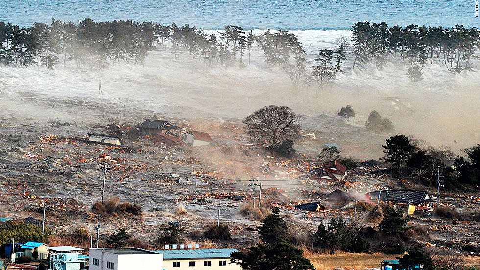
The Tōhoku earthquake and tsunami, which occurred on March 11, 2011, did not claim as many lives, the its effects were dramatic. It apparently shifted the entire island of Honshu (the main island of Japan) a full 2 metres to the east. The earthquake was the largest ever to hit the island nation and the fifth most powerful earthquake in modern record. The tsunami reached heights of near 40 metres in places, and affected over 500 square kilometres of the coastline. The combined event claimed over 15,000 lives, and in 2011 the World Bank reported that the damage estimate could reach $235 billion, apparently making it the most costly disaster ever.
[ More Geekquinox: Magnitude 5.5 earthquake shakes southern Mexico ]
Tsunamis aren't limited to the Pacific, though. For example, a magnitude 7.2 earthquake in the Grand Banks, south of Newfoundland, caused a tsunami that impacted on the Burin Peninsula on November 18th, 1929, killing 28 people.
There are also some fairly big concerns about a potential mega-tsunami originating from the volcano on the island of La Palma, in the Canary Islands, Spain. If this volcano suffered a major eruption, it could cause half the mountain to slide into the Atlantic Ocean, touching off a massive wave. Projections give, at most, eight hours before a 50 metre-tall wave washes ashore along the eastern seaboard of North America, wiping out all coastal communities.
To learn more about tsunamis and the dangers they represent, you can go to NOAA's TsunamiReady website: www.tsunamiready.noaa.gov
Geek out with the latest in science and weather.
Follow @ygeekquinox on Twitter!
