
A Caribbean system is forecast to bring rain to South Florida, and Epsilon back to Cat 1
Forecasters on Thursday were watching a new disturbance in the western Caribbean Sea that is forecast to bring heavy rain to portions of South Florida, Cuba and the Bahamas through early next week as it moves toward the western Atlantic.
They’re also tracking Hurricane Epsilon, which is passing well east of Bermuda after weakening back into a Category 1 hurricane, according to the National Hurricane Center.
Here’s what to know:
How will the disturbance in the Caribbean Sea affect South Florida?
The disturbance, described as a trough of low pressure, was producing a large area of disorganized showers and thunderstorms Thursday night, primarily near Jamaica, the Cayman Islands, Cuba and the Windward Passage, according to the hurricane center.
“Some slow development of this system is possible during the next few days while it moves northeastward near western or central Cuba, the Straits of Florida and the central Bahamas through the weekend,” forecasters wrote.
It has a 10% chance of development in the next two days and a 30% chance of development through the next five days, according to the 8 p.m. advisory.
Regardless of development, the system is expected to bring heavy rainfall to portions of Cuba, South Florida and the Bahamas through early next week, forecasters said.
While Friday will be a bit drier for Miami-Dade and Broward County, the chances of rain are still between 40% to 60%, according to the National Weather Service. The moisture from the Caribbean disturbance is expected to bring a 50% to 60% chance of rain to South Florida during the weekend, with higher rain chances along the coastal areas, forecasters said.
The good news is that South Florida is expected to be drier next week, the weather service said.
Tracking Hurricane Epsilon: Where is it going?
As Epsilon passes Bermuda, forecasters say winds affecting the country will subside overnight. Bermuda has also discontinued its tropical storm warning.
The hurricane is not a threat to the United States, although dangerous and potentially life-threatening surf and rip currents are expected along the coasts of Bermuda, the Bahamas, the Greater Antilles, the Leeward Islands, the east coast of the United States and Atlantic Canada during the next couple of days.
Hurricane Epsilon has maximum sustained winds near 85 mph with higher gusts, according to the National Hurricane Center’s 11 p.m. advisory Thursday.
As of that update, the storm was moving north-northwest at 9 mph and was about 190 miles east of Bermuda.
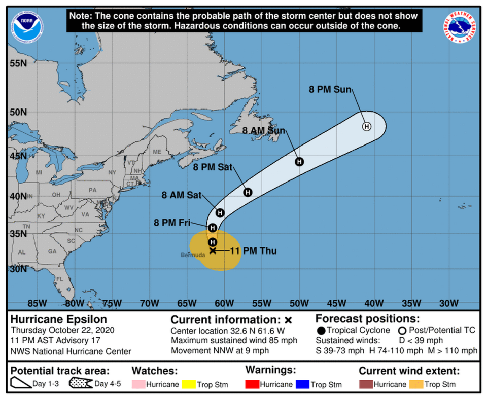
Epsilon also shrunk a bit Thursday — with hurricane-force winds now extending 15 miles out from the center and tropical-storm-force winds extending up to 240 miles from the center, mainly to the north.
Epsilon is forecast to pick up speed as it moves toward the northeast Saturday, eventually taking it past southeastern Newfoundland and into the North Atlantic early next week, where it is expected to merge with a frontal zone and become extratropical.

