
Clouds, rain stave off treacherous GTA air quality, pattern change ahead
Visit The Weather Network's wildfire hub to keep up with the latest on the active start to wildfire season across Canada.
Thursday brought an unexpected breath of relief to parts of southern Ontario that headed into the day bracing for horrid air quality from wildfires raging throughout interior Quebec and northern Ontario.
Widespread clouds across the region, combined with rain upwind from southern Ontario, diminished the expected plumes of wildfire smoke that ultimately reached the area during the day Thursday.
PHOTOS: Canadian wildfires cause hazy skies, poor air quality in Canada, US
Conditions staved off historically bad air quality
Clouds and rain were a ‘wild card’ in Thursday’s air quality forecast for southern Ontario and the Greater Toronto Area (GTA), and thankfully that uncertainty surrounding the weather’s impact on the smoke played out in residents’ favour.
RELATED: AQI, AQHI, and your health: Air quality ratings explained
According to Environment and Climate Change Canada (ECCC), the Air Quality Health Index (AQHI) in Toronto proper only reached 5, or moderate, during the early afternoon hours on Thursday.
Forecasters had feared that air quality readings would reach near-unprecedented levels over the same timeframe, but clouds and rain prevailed to prevent the worst from unfolding. Clouds hindered the explosive development of ongoing fires, while rain helped draw some of the smoke out of the air.
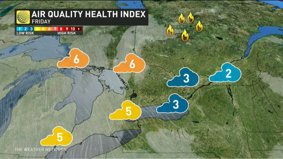
Friday will feature moderate AQHI values across portions of southern Ontario, with folks in the GTA and areas west expecting an AQHI of around 5, with slightly poorer air quality up toward the Nickel Belt.
Hundreds of fires continue burning
As of Thursday evening, there were around 128 active wildfires burning in Quebec and scores of fires burning in northern Ontario, as well.
By this time last year, 205 fires had burned throughout Quebec. This year so far, the province has seen over 440 wildfires, with roughly 1.3 million hectares of land burned — far surpassing the 1991 total of about 350,000 hectares.
WATCH: What exactly is in wildfire smoke, and how can we protect ourselves?
A pattern change is on the way
The wildfire smoke choking parts of Ontario, Quebec, and the U.S. East Coast this week was largely the result of an Omega block parked over Canada.
This blocking pattern kept upper-level conditions consistent for days at a time, providing the northerly flow that pumped copious amounts of smoke southward into some of the continent’s most populated regions.
DON'T MISS: What’s in wildfire smoke? Toxicologist explains health risks, best masks to use
We’ll finally start to see this upper-level pattern break down heading into the weekend, which will bring much-needed relief to communities that have experienced their worst air quality levels in recent memory.
As a fresh pattern develops, we’ll see a new upper-level low swing over the Great Lakes region, bringing with it both a wind shift and widespread precipitation into the weekend.

A threat for scattered, non-severe thunderstorms will appear over southern and eastern Ontario during the day Friday. Be aware that lightning in these storms could trigger additional fires in cottage country.
We’re on track to see widespread, beneficial rains throughout southern and eastern Ontario this weekend and early next week.
While it won’t be enough to extinguish ongoing fires across Quebec—and it’ll largely miss the most widespread fire activity there—the precipitation should make conditions less favourable for the growth of existing fires and spark of additional blazes.
Thumbnail image courtesy of NOAA.
Stay with The Weather Network for the latest on conditions across Ontario and Quebec.

