
Coastal Nova Scotia under tropical-storm warning as Teddy moves closer

There's less than 24 hours until Nova Scotia starts to feel the effects of hurricane Teddy, but there's still a large range for where the storm could actually track over the province.
In an update Monday evening, CBC meteorologist Ryan Snoddon said Teddy remains a strong Category 1 hurricane and is undergoing a post-tropical transition.
As it does, there's a chance that the storm briefly strengthens back to Category 2 hurricane overnight Monday.
There is a tropical-storm warning in effect for coastal Nova Scotia as of 3 p.m. Monday, and a less-intense tropical-storm watch for central and northern counties.
Teddy is expected to become a post-tropical storm when it arrives in the region, and should bring heavy rain, strong winds and pounding surf to much of the Maritimes and southern Newfoundland.
Major winds expected Wednesday
The first round should arrive through Tuesday morning and ramp up for the afternoon and evening hours, Snoddon said.
Widespread gusts of 60 to 80 km/h are expected across Nova Scotia with coastal gusts above 90 km/h. Rainfall amounts from this first section should range from 25 to 50 mm for Nova Scotia, P.E.I. and southeast New Brunswick.
There will be a lull overnight Tuesday before round two arrives with the centre of Teddy on Wednesday afternoon, bringing another round of rain and strong winds.
The Atlantic coast of Nova Scotia, including Halifax and Cape Breton, could see gusts in the 70 to 100 km/h range on Wednesday afternoon.
The current track has Teddy crossing just east of Halifax and over the northeast corner of the province.
But Bob Robichaud, meteorologist with the Canadian Hurricane Centre, said the field of the storm could see it easily swing west of the capital city, or move east offshore of Cape Breton.
"All of that area is still on the table in terms of the track of the storm," Robichaud said.
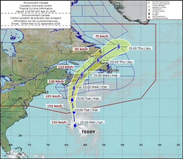
The strongest winds will fall to the right side of the storm as it goes by on Wednesday, and could reach 80 to 100 kilometres per hour or higher in exposed areas on the east coast.
The heaviest rain — anywhere from 50 to about 100 millimetres — is going to be to the left of the track, which as of Monday evening will likely be central and eastern Nova Scotia.
Robichaud said he's mostly keeping an eye on the east part of the Eastern Shore, and Cape Breton, as the areas that could see the most damaging winds on Wednesday.
If the storm tracks west of Halifax, that would put "a very significant portion" of the province under an area with the strongest winds. But if it trends farther east, those strong winds will just cover a "very small portion" of eastern Nova Scotia.
"A track for the east would generally mean fewer impacts for the Maritimes, in terms of wind especially," Robichaud said.

With the centre of the storm still 48 hours away, he said that wide range of track is still significant.
A couple of different factors will impact the direction of the storm, Robichaud said. They include an area of high pressure to the north and to the west that will dictate when Teddy turns towards the northeast.
It's also becoming embedded within some winds in the upper levels of the atmosphere.
"Exactly when that occurs and where it occurs is all going to dictate where the centre of Teddy actually goes," he said. "But right now, we're focusing on that area of the Eastern Shore between Halifax and Canso."
Large waves will approach later on Tuesday afternoon, so people along the coast should keep a close eye on the water during the evening hours and especially near high tide around midnight Tuesday night into early Wednesday.
Snoddon is calling for three- to four-metre waves on Tuesday morning that will build to seven to nine metres later in the day, with waves breaking higher along parts of the coast.
With a storm surge of 50 centimetres expected, he said there could be coastal damage overnight Tuesday at high tide around midnight. Storm-surge warnings are in effect for the Atlantic coast of Nova Scotia, from Shelburne County to Guysborough County.

"The type of waves that we expect to arrive at the coast should be fairly high-energy waves. So this should pack a significant punch, especially in that evening hours of tomorrow into the overnight hours," Robichaud said.
Robichaud said there definitely could be some coastal flooding, possibly even significant flooding, especially along the Eastern Shore.
Teddy is coming nearly exactly a year after Hurricane Dorian, which brought major damage and power outages across the province and Maritimes, but Robichaud said the "wind field" for Teddy is not nearly as large as Dorian and won't bring as much rain.
However, winds from Teddy could break tree branches and lead to downed power lines. People are reminded to stay away from the shore, since the combination of surge and large waves could lead to dangerous rip currents.
For southwest Nova Scotia, including the site of a fishery dispute between Mi'kmaw and non-Indigenous lobster fishermen, Robichaud the main concern would be the potential of high waves.
In Herring Cove on Monday, Tom Reyno was hopeful a new seawall and lots of straps would keep his dock in place when Teddy arrived.

When Dorian tore through the area last fall, Reyno said the waves smashed the breakwater that has yet to be repaired and took out 30 feet of shoreline.
It also lifted Reyno's boathouse off its moorings and carried it to sea.
"I don't think there is such a thing as hurricane-proof. Mother Nature is going to win every time," he said.
But this year, he's taken steps to avoid major damage. He's strapped down a new walkway and has his fingers crossed the 100 tonnes of rock and boulders installed into a seawall will bear the brunt of the surge.
Reyno also pulled both his boats out of the water and noticed this week there was a long line at Dingle Park in Halifax of people waiting their turns to do the same.
"People are preparing for this I think and if you look along the shoreline, everyone's been scurrying around," Reyno said.
Utilities prepare for storm
Nova Scotia Power said it opened its emergency operations centre at noon on Sunday to prepare for possible power outages.
On Monday afternoon, a convoy of power trucks could be seen on Highway 104 in the Pictou and Colchester counties heading to their positions.
Halifax Water is also taking various precautions to prepare for Teddy. Those include filling fuel tanks and water reservoirs, testing backup power generators, securing construction sites and clearing drains and pipes in flood-prone areas.
People are encouraged to report any blocked catch basins or culverts in their areas and to proactively prepare any privately-owned drainage systems or properties that are prone to flooding.
Halifax Water's emergency operations centre will operate around the clock throughout the storm.
'The more we can do now, the better'
The Baddeck waterfront has been a hive of activity since the weekend.
Baddeck Marine manager Tyler Germani said he's been going flat out since Friday getting boats out of the water.
"I mean, it's a quieter year in general, but we've probably hauled a little over 40 boats in the last couple of days, getting ready for the storm."
Germani said the boating season isn't over yet, but most owners are pulling their boats out and they won't go back in until next year.

"There's not too many left in the harbour, that's for sure," said Germani. "Only a couple, and they're on secure moorings."
In North Sydney, the Northern Yacht Club has also pulled out seven boats and another three left for calmer waters at the nearby Ballast Grounds wharf.
Commodore John Astephen said the rest are adding extra tie-downs and taking down sails to ride out the expected high winds and waves.
"You're always a little worried and there's always that apprehension," he said.
"We'll certainly be keeping an eye [out], but what we try and do is prepare well beforehand. During the storm itself, it's not nice being out, it's probably not safe, so the more we can do now, the better. And for the most part that's been done."
Astephen said the club is applying some lessons learned during post-tropical storm Dorian last year, including moving boats off the docks next to the shore.
That part of the marina is more exposed to wind and waves, he said.
Doug Milburn was on board his sailboat at the Ben Eoin marina, adding some tie-downs and taking in a headsail on the bow.

He said the wind is forecast to be about 40 knots, or about 80 kilometres per hour, which is not uncommon in Cape Breton.
"It's not that big a deal around here," Milburn said. "In Cape Breton, we get lots of wind that's over 80 kilometres an hour."
The Ben Eoin marina is sheltered by trees on either side and a large breakwater in front.
Milburn said the marina easily weathered Dorian and will likely be safe from Teddy this week, but he is still battening down the hatches.
"You've got to be prudent, because you never know exactly what it'll end up to be, but I'm not that worried about it by the sound of it."
Tuesday night ferry crossings cancelled
Marine Atlantic spokesman Darrell Mercer said the federal ferry service changed its schedule for Tuesday.
"We originally anticipated that the Tuesday morning crossings may be impacted, but it looks like the storm has slowed a little, so that's allowing us to get the crossing in [Tuesday] morning," he said.
"Unfortunately, the night crossings will be cancelled."
Mercer said customers who booked passage on the 11:45 a.m. trip to Port aux Basques are being notified and the schedule is being updated because that crossing on Tuesday morning will be leaving an hour earlier, at 10:45.
"Because there is that small window to get the crossing in before the storm arrives, the vessels will be leaving an hour earlier, so that'll allow us to get in before the winds start to pick up in both Cape Breton and in southwestern Newfoundland," he said.
Decisions on Wednesday crossings are expected to be made later.
MORE TOP STORIES

