
Snowstorm to bring treacherous Wednesday travel in southern Ontario
For many areas in southern Ontario, Wednesday's storm will bring their heaviest snowfall of the year so far. A widespread 10-25 cm is expected. When combined with intense wind gusts, the Wednesday afternoon and evening commute will be quite hazardous at times due to poor visibility from blowing snow.
This won't be the end of it, either, with several storm systems expected to follow behind Wednesday's Texas low, bringing more wintry weather back into clear focus for the region as we end off the month.
RELATED: What has derailed so many southern Ontario storms this winter
Snow will begin to spread across southwestern Ontario through the morning hours on Wednesday, with snowfall rates forecast to intensify through the late afternoon and evening hours, especially for the GTA.
Snowfall rates of 1-3 cm an hour are forecast at times, with conditions expected to be at their worst in the afternoon hours and into the evening commute.
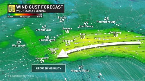
"Higher snowfall rates in combination with easterly winds between 40-60 km/h blowing off Lake Ontario will lead to reduced visibility and even brief whiteouts possibly," warns Kelly Sonnenburg, a meteorologist at The Weather Network.
Snowfall accumulations of 10-25 cm are possible. The snow will taper to flurries by the Thursday morning commute across the GTA.

For Ottawa, snow will becoming heavier after the Wednesday evening commute and become heaviest through the overnight period. Snow will still continue through the Thursday morning commute, but will become lighter through the morning.
WATCH: Will Ontario storm finally bring 'winter,' or will it get derailed again?
String of wintry lows continue behind this mid-week system
Several systems behind this Texas low will continue the string of wintry lows forecast to bring rounds of snow to Ontario through next week.
More snow is forecast late Friday into Saturday morning, with a clipper system and possibly more widespread snow Sunday through Monday once again. There is lower confidence in the forecast details this far out, but at this point, it's not expected to be a major storm.
A more wintry pattern will stay locked in for the final days of January and into early February, with an active setup expected to continue as we march through the heart of the winter season.
WATCH: Three things to know about Ontario’s incoming storm
Check back in with The Weather Network for updates on the forecast for Ontario.
Depending on where in Canada you live, your snowfall threshold could vary. ❄️ 🌨 In your opinion, how much is "too much" for your region? #TWNPoll
Depending on where in Canada you live, your snowfall threshold could vary. ❄️ 🌨
In your opinion, how much is “too much” for your region? The Weather Network on Twitter: "Depending on where in Canada you live, your snowfall threshold could vary. ❄️ 🌨 In your opinion, how much is "too much" for your region? #TWNPoll / Twitter"— The Weather Network (@weathernetwork) The Weather Network on Twitter: "Depending on where in Canada you live, your snowfall threshold could vary. ❄️ 🌨 In your opinion, how much is "too much" for your region? #TWNPoll / Twitter"

