
Crest has passed, Red River starting to drop in Winnipeg


The Red River flexed, puffed up its chest and threatened some properties in Winnipeg, but it has crested with little damage beyond some submerged riverbanks.
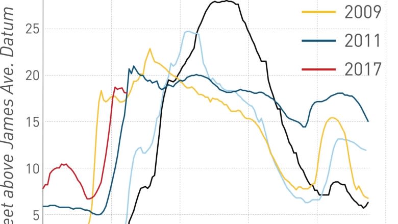
According to the province, the crest inside Winnipeg limits reached 19.4 feet above normal winter ice level at James Avenue early Saturday morning and then again late Monday evening. As of Wednesday at noon, it was 18.7 feet James.
That's an artificial crest controlled by the floodway, however. The natural crest for the Red outside of Winnipeg is yet to come in a day or two.
The province activated the Red River Floodway on March 31 to control levels within the city.
The floodway works by partly damming the river. Control gates, which are stored below riverbed level, are raised, restricting the river's flow into the city.
The water backs up and the level rises until it flows into the nearby floodway channel, which follows a 47-kilometre route around the east side of Winnipeg, from an inlet near St. Norbert to an outlet near Lockport.
Without the benefit of the floodway, the water level at James Avenue on Tuesday would have been more than five feet higher, at 24.9 feet, according to the province, which issued a news release on Wednesday.
The Assiniboine River crest is still a few days away and it is more difficult to predict how much it will rise because it is fed by several tributaries along the way. The province is also using the Portage Diversion to control how much water reaches Winnipeg.
The diversion is a 29-kilometre channel that starts at an inlet near Portage la Prairie and goes north, emptying into Lake Manitoba.
Ice is moving along portions of the Assiniboine from Portage la Prairie to Headingley, just west of Winnipeg, which has led to a flood watch for that area, the province said.
Although the Portage Diversion is being operated to limit flows from the Assiniboine into Winnipeg, as well as minimize ice jamming, it can't divert everything.
As flows increase and the diversion approaches capacity, additional water could end up being allowed downstream, impacting communities along the river and into Winnipeg.
What is meant by 'James'?
In Winnipeg, river levels are measured by the height in feet of the water above normal winter ice levels at the James Avenue pumping station.
The James Avenue location was chosen because it's where the city's main pumping station operated at the time.
- Normal Winter Ice Level — 0 James.
- Normal Summer Level — 6.5 feet James.
- Riverwalk Level — 8.5 feet James.
- 1997 Flood Peak — 24.5 feet James.
- 2005 Flood Peak — 20.1 feet James.
- 2006 Flood Peak — 20.4 feet James.
- 2009 Flood Peak — 22.6 feet James.
- 2011 Flood Peak — 20.7 feet James.
