
First alert of 2024 hurricane season: Tropical storm watch on Texas coast
The 2024 Atlantic hurricane season is heating up.
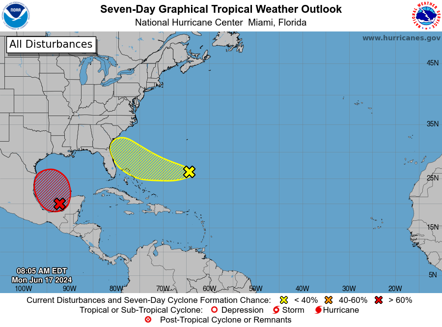
A system in the Gulf of Mexico that will soon become Tropical Storm Alberto has prompted a tropical storm watch for the Texas coast, the first alert of the 2024 Atlantic hurricane season. On Monday afternoon, the National Hurricane Center issued an advisory for potential Tropical Cyclone One.
Heavy, potentially flooding rain is expected across the western Gulf Coast, the National Hurricane Center said, with as much as 15 inches possible. The heavy rainfall and flash flooding threat is predicted to intensify into Tuesday morning, according to National Hurricane Center Director Michael Brennan.
A tropical storm watch has been issued for the Texas coast from Port O'Connor southward to the mouth of the Rio Grande. The watch means tropical storm conditions are possible within the area, generally within 48 hours.
"There's a potential for flooding and flash flooding over the next several days with heavy rainfall already starting to move into portions of the Gulf Coast," Brennan said in an update Monday afternoon. "This threat of flooding is going to continue as we move through the week."
The system's maximum sustained winds remained near 40 mph with higher gusts as of 11 p.m. EST Monday. The National Hurricane Center described the system as "quite large" with tropical storm-force winds extending outward up to 290 miles to the northeast of the center.
The hurricane center has forecast the system to become a tropical storm by Wednesday and advised residents along the western and northwestern Gulf coasts to closely monitor it.
By 11 p.m. Monday, the system was moving near 7 mph toward the north, according to the hurricane center. It was expected to turn toward the west-northwest by Tuesday night or Wednesday, and "the system is likely to approach the western Gulf coast late Wednesday," the hurricane center said in a late Monday advisory.
It's one of two separate tropical systems – the other is in the Atlantic Ocean – that are forecast to strengthen this week and each could have an impact on portions of the southern U.S., forecasters said Monday.
Alberto will be the first named storm of what's expected to be a doozy of an Atlantic hurricane season.
Tropical storm in the Gulf?
The Gulf system is forecast to strengthen into a tropical depression, then a tropical storm right before making landfall along the northern Gulf Coast of Mexico, AccuWeather said. Once its sustained winds reach 39 mph, it will become Tropical Storm Alberto.
Although the center of the storm will likely make landfall in Mexico on Wednesday, the National Hurricane Center warned that heavy rainfall is still expected to spread over portions of the northwestern coast of the U.S. Gulf of Mexico by the middle of the week. In addition, gale warnings have been issued for portions of the Gulf of Mexico.
AccuWeather senior meteorologist Dan Pydynowski explained that "even if the tropical storm falls short of reaching tropical storm status, a plume of rich, deep tropical moisture is expected to surge into Mexico, Texas and Louisiana into the middle of the week."
Weather Channel meteorologist Jim Cantore warned that "double-digit rainfall totals (are) likely along the coastal counties of Texas and potentially Houston." Flash flooding is a possibility in some parts of Texas, including in Brownsville, Corpus Christi, Houston and San Antonio, according to Weather.com.
An Air Force Reserve Hurricane Hunter aircraft is scheduled to investigate the system later Monday.
Busy season ahead: The 2024 NOAA hurricane season forecast is unlike any other. See the record predictions.
Atlantic system also bears watching
Forecasters on Monday were also keeping watch on a budding tropical system in the Atlantic Ocean. The system, which was several hundred miles east of the Bahamas on Monday, "is forecast to approach the coast of the southeast United States on Thursday or Friday," the Hurricane Center said.
"This appears to be a quick-moving and compact low-pressure area that will be moving westward into northeastern Florida or perhaps as far north as southeastern Georgia on Thursday," Pydynowski said.
Locations from Melbourne, Florida, to Charleston, South Carolina, will be at risk for heavy rain from the storm.
The National Weather Service in Jacksonville, Florida, warned of "numerous to widespread showers and embedded heavy storms pushing onshore at times with strong gusty winds as the main threat."
An 'extraordinary' year is possible
Once Alberto forms, it will be the start of what's expected to be a very active year for storms. NOAA Director Rick Spinrad said last month that the Atlantic hurricane season is shaping up to be "extraordinary," with an "85% chance for an above-average year."
The record for most named storms in a season is 30, set in 2020. A typical year averages about 14 tropical storms, seven of which spin into hurricanes, based on weather records spanning from 1991 to 2020.
Contributing: Cheryl McCloud and Kim Luciani, USA TODAY NETWORK - Florida
This article originally appeared on USA TODAY: Tropical storm brewing as hurricane season begins
