
Fiona's trajectory, power and precipitation — illustrated in graphics
Hundreds of thousands of people in the Maritimes remained without power Sunday following post-tropical storm Fiona, which brought fierce gusts of wind, heavy rain and serious infrastructure damage across Atlantic Canada.
After surging north from the Caribbean, Fiona came ashore before dawn Saturday as a post-tropical cyclone, battering Nova Scotia, Prince Edward Island, Newfoundland, New Brunswick and Quebec with hurricane-strength winds, heavy rains and huge waves.
Defence Minister Anita Anand said troops would help remove fallen trees throughout Eastern Canada, restore transportation links and do whatever else is required for as long as it takes. She didn't specify how many troops would be deployed.
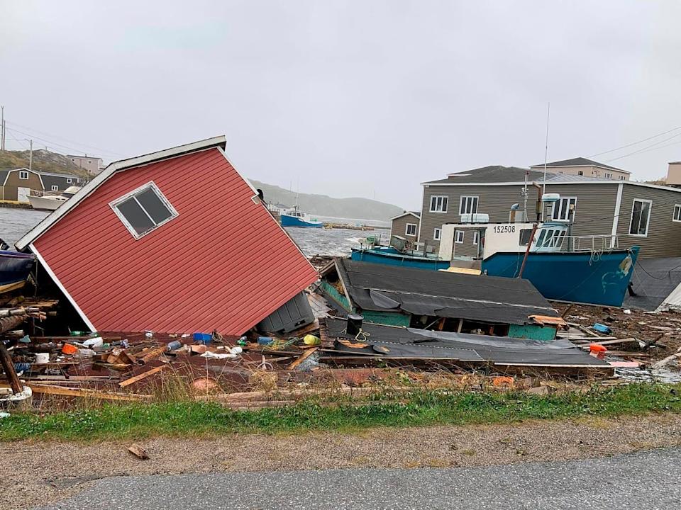
Fiona was blamed for at least five deaths in the Caribbean. There was at least one confirmed death in Canada, a 73-year-old woman who was washed out of her home in Port aux Basques, N.L., one of the hardest-hit areas.
These graphics show: Fiona's path into Canada and how it compared with other recent storms; areas in the Maritimes with the highest levels of rainfall; and the parts of Atlantic Canada with the strongest wind gusts.
How Hurricane Fiona's path compares with other storms
As of Sunday morning, more than 256,000 Nova Scotia Power customers and over 82,000 Maritime Electric customers in Prince Edward Island — about 95 per cent of the total — remained in the dark. So were more than 20,600 homes and businesses in New Brunswick.
More than 415,000 Nova Scotia Power customers — about 80 per cent of the province — had been affected by outages Saturday. Utility companies say it could be days before the lights are back on for everyone.
Rain
The Canadian Hurricane Centre tweeted that Fiona had the lowest pressure — a key sign of storm strength — ever recorded for a storm making landfall in Canada.
The storm brought nearly 200 millimetres of rain to parts of Nova Scotia and up to 150 mm in parts of New Brunswick, according to Environment Canada.
Charlottetown, the capital of P.E.I., faced 80 millimetres of rain and Wreckhouse, N.L. was hit by 77.2 mm.
How much rain Fiona brought to Nova Scotia
Wind
Fierce winds caused much of the damage brought on by the storm, including downed power lines and trees.
In Nova Scotia, Peter MacKay, a former foreign and defence minister, said he had never seen anything to match Fiona, with winds raging through the night and into the afternoon.
"We had put everything we could out of harm's way, but the house got hammered pretty hard. Lost lots of shingles, heavy water damage in ceilings, walls, our deck is destroyed. A garage that I was building blew away," MacKay said in an email to The Associated Press.
How much wind Fiona brought to Nova Scotia
In Newfoundland and Labrador, winds whipped up to 177 km/h in Green Island and 134 km/h in Port aux Basques, a community devastated by Fiona.
In New Brunswick, Moncton faced top wind speeds of 100 km/h followed by Saint John with 86 km/h. On Prince Edward Island, Charlottetown faced gusts of 130 km/h and Arisaig, N.S., saw winds of up to 171 km/h.
Places in Atlantic Canada hardest hit by Fiona's whipping winds
