
Icy conditions threaten morning commute for parts of Ontario, Quebec
Get ready for an icy Thursday morning commute across parts of eastern Ontario and southern Quebec as a round of freezing rain covers the region. Icy surfaces will make for hazardous driving conditions for folks around Ottawa and Montreal.
This threat for freezing rain arrives amid a spectrum of active, classically springtime weather hitting Ontario and Quebec into next week. Rain, snow, freezing rain, thunderstorms, gusty winds, and even localized flooding due to snowmelt are all possible with the trio of storms on the way.
RELATED: A trio of storms will showcase what a Canadian spring is all about
Freezing rain risk for Thursday morning commute
While parts of northern Ontario deal with up to 20 cm of snow through Thursday morning, folks across eastern Ontario and southern Quebec are on the lookout for icy roads as a result of freezing rain.

Travel may become difficult in the Ottawa Valley and St. Lawrence River overnight Wednesday into Thursday morning as freezing rain coats exposed surfaces in a glaze of ice.
Some areas could see 2-4 mm of ice accretion on surfaces and untreated roads through the Thursday morning commute. Motorists will need to use extra caution and plan some additional time into the morning routine.
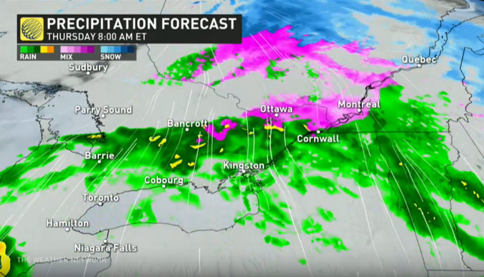
Freezing rain warnings are in effect through late Thursday morning, including the cities of Ottawa and Montreal.
"Surfaces such as highways, roads, walkways and parking lots may become icy and slippery. Be prepared to adjust your driving with changing road conditions," says ECCC in the warning.
Across southern Ontario and Quebec, widespread rain beginning Wednesday evening will spread eastward through the day Thursday.
Generally, between 10-15 mm of rain is expected across much of southern Ontario and Quebec, but up to 20 mm is likely from London to Windsor, Ont. There is even the potential of a weak thunderstorm to develop.
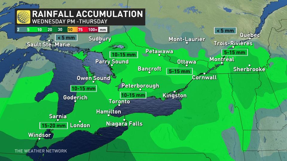
Temperatures will reach the double digits across southern Ontario in the warm sector of the low, with some daytime highs reaching into the mid-teens on Thursday in the extreme southwest.
Thursday’s warmth will quickly put an end to the freezing rain by the late-morning hours in Montreal, where an above-seasonal high of 6°C is possible through the afternoon.

The relative warmth and rain are expected to extend as far north as Sault Ste. Marie and Sudbury, Ont., by Thursday morning.
A robust, moisture-laden storm from the southern U.S. will track into the Great Lakes this weekend, bringing widespread windy conditions to central Ontario and western Quebec. This system could bring a period of freezing rain northwest and west of the Greater Toronto Area.
Changeable temperatures are expected for the final days of March through early April, with no sustained warm weather in sight.
Stay tuned to The Weather Network as we continue to update this week's forecast for Ontario.

