
Head's up B.C.: First significant snowfall of season heads for lower elevations
Parts of the Lower Mainland will face their first significant snowfall of the season on Tuesday and Wednesday due to a low pressure system interacting with an Arctic outflow, which will bring frigid temperatures and gusting winds.
While B.C. has seen several snow events in higher terrain, some areas like Burnaby and eastern areas of Vancouver Island have only had light snowfall accumulations.

"It is now time for Vancouver and Abbotsford to see their first significant snowfall of the season," says The Weather Network meteorologist Matt Grinter.
Forecast models are indicating some uncertainty about how much snow could accumulate in parts of the Lower Mainland due to the drier air in place at the start of the system.
Related: Simple tricks for effectively priming your car for winter driving
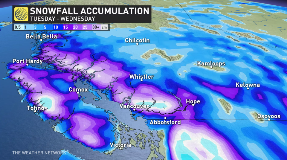
There is higher confidence that upwards of 20-30 cm of snow is possible in the Fraser Valley near Abbotsford and Hope, with lesser amounts of 10-20+ cm in the suburbs of Metro Vancouver. There is lower confidence in the amount of snow that could accumulate in coastal sections of Richmond and Delta.
Wind gusts up to 60 km/h are expected Monday afternoon and could reach 80 km/h by Tuesday, especially in the Strait of Georgia.
Check back frequently to The Weather Network for updates as this system has the potential to be a high-impact weather event.
WATCH BELOW: Do your winter tires need replacing? Use this simple trick to check
Thumbnail image created by Cheryl Santa Maria using graphical elements from Canva.

