
Heavy snow, strong winds expected from weekend storm in south Sask.

Snowfall and blizzard warnings are in effect for southern Saskatchewan in advance of a clipper system coming in from the west coast this weekend.
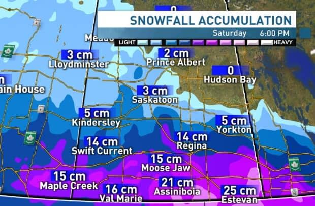
The snowfall warning includes the cities of Swift Current, Moose Jaw and Regina, while the blizzard warning includes Weyburn, Estevan, Carlyle and Oxbow.
The system could drop between 10 and 20 centimetres of snow through the south from Friday evening to late Saturday afternoon. The most is expected in the southeast corner, where snowfall could top 25 cm.
"I think the heaviest of the snows will be in the overnight period, which is sort of a good thing because [there are] not too many people out on the roads then," said Terri Lang, a warning preparedness meteorologist with Environment Canada.
The system is expected to start around the supper hour Friday in the southwest, before moving eastward through Friday night and Saturday.
Strong southeast winds up to 70 kilometres per hour will likely create blizzard conditions, reducing visibility on highways until winds diminish Saturday morning.
City of Regina gearing up for blizzard
Tyler Bien, the City of Regina's manager of seasonal roadway operations, told media on Friday that the city is taking this storm seriously.
"Ten centimetres of snow isn't nothing, right? And 70 [kilometres per hour] winds along with that will pose some issues on the roads with the drifting snow," he said.
Bien said the city's team operates 24 hours a day, seven days a week when there is a storm, and this weekend's chilly blast will be no different.
He said the city will have approximately 50 pieces of equipment on the road at any given time.

Once the snow starts, the city will focus on keeping traffic moving on major thoroughfares like the Ring Road and Lewvan Drive, Bien said.
When the snow stops, workers will move to a systematic process that targets major roads and then residential streets.
He urged residents to be caution when driving during the storm.
"If you do have to travel, plan your route, plan to stay away from those perimeter areas. Any area that will be next to an open area. Typically those tend to be worse when we get a heavy wind storm like this," he said.
In a statement, the City of Regina confirmed that its extreme weather committee met with community based organizations supporting homeless individuals in the city ahead of the storm.
"Recent discussions with this committee do not indicate an immediate need to reinstate the warming bus," it said.
Impact still somewhat uncertain
The exact track of the storm system depends on a broad, intense area of high pressure encompassing northern Saskatchewan and Manitoba.
The dry air within the high pressure area prevents snow from forming, so the system could struggle to gain steam as it rolls though our province, leaving the heavy snow for areas south of the international border.

But forecast models have remained consistent so far, predicting the highest accumulations for extreme southeastern Saskatchewan.
The low pressure system responsible for this wintry wallop formed from an atmosphere river striking the Pacific coast of the United States. The San Bernardino Mountains in southern California received more than 250 cm of snow as a result of that system earlier this week.
Lang said it's not unusual for Saskatchewan to get a blizzard at this time of year.
"We always get a good couple of storms in March, in April and in fact some of our heavy snowfalls occur in the spring," said the federal meteorologist.
Good timing for dry fields
In its spring runoff forecast released Thursday, the province's Water Security Agency says much of southern Saskatchewan went into winter with little moisture.
South central and southwestern regions received below normal snowfall and had much of their snow pack melt through the winter, so this storm will be welcome for farmers dealing with dry fields.

Much of those regions are also seeing moderate to severe drought as of the end of January, according to Agriculture and Agri-Food Canada's drought monitor.
After this system passes by, much of the province will see a less active weather pattern and a return to normal temperatures after a chilly start to March.

