
A historical curiosity: A little piece of New Brunswick is in Nova Scotia

New Brunswick has had its share of boundary disputes over the years, almost going to war with the state of Maine in 1839 then squabbling with Quebec over Lake Temiscouata a few years later.
But along the Missaguash River between Aulac, N.B., and Amherst, N.S., there's nary a whisper of contention over a five-hectare historical curiosity.
No farmers fluster. No politicians bluster. No militias muster.
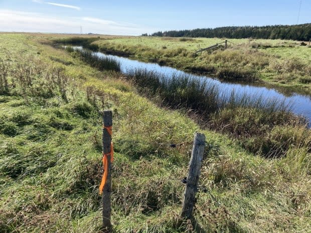
The Missaguash is a narrow, murky channel regulated by dikes and aboiteaux that keep the Bay of Fundy from flooding the soil here with salt water.
It's also the boundary between New Brunswick and Nova Scotia — except at one lot, PID No. 70395462.
That parcel has an official New Brunswick land registry number, though it sits on the Nova Scotia side of the river.
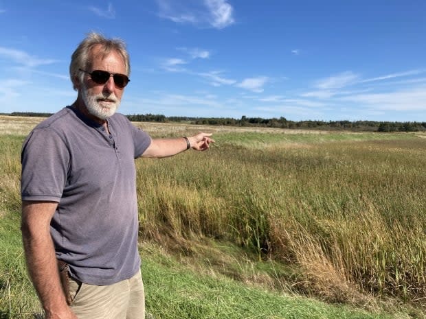
Fredericton engineer Rob Hoadley noticed the anomaly last year, when provincial boundary shutdowns got him poking around maps of the area.
"I'm just that kind of guy to get curious about that kind of stuff," he says. "At a time when we couldn't physically cross the border, here's a spot that may or may not be in New Brunswick."
A federal government atlas shows the boundary running down the river, which would put the land in Nova Scotia. Election New Brunswick's official map of the riding of Memramcook-Tantramar does not include the property.
But a Nova Scotia online map shows the border deviating from the river to wrap around the parcel of land, placing it in New Brunswick.
And that map is the correct one, says its owner.
"We own the property and we pay taxes on it," says Edie Helm, who grew up on her family's farm on the New Brunswick side of the river.
Helm lives in Amherst but the property taxes for the land are levied by, and paid to, New Brunswick.
But how can that be?
The Missaguash has been the boundary between the two provinces since King George III approved carving New Brunswick out of what used to be a much larger Nova Scotia on June 18, 1784.

The order-in-council said the boundary would be established by "drawing a line of separation from the Mouth of the Musquat [Missiguash] River" to its source.
The two provinces confirmed that almost a century later when they passed legislation identifying the Missaguash as the boundary.
But that was then.
"The river would have had a different routing in its earlier days," says local farmer John Atkinson.
The farmers at that time were more concerned about getting proper drainage than worrying about on what side to the border their land was going to be on. - Hank Kolstee, retired agricultural engineer.
In 1949 the federal government took over maintenance of the dike system here under the Maritime Marshland Reclamation Act.
The river's meandering watercourse featured an oxbow, a U-shaped bend in the river that wrapped almost entirely around this teardrop-shaped parcel of land.
That presented a drainage problem.The dike system was designed to let the river's freshwater current out without allowing salt water in.
"That could cut the distance in that particular area by about a third, so you could get much better water flow in that area," says Hank Kolstee, a retired agricultural engineer who worked at the Nova Scotia Agricultural College and worked on marshland projects.
In this case, a new channel shifted the river to the north of the five-hectare parcel of land.
It also produced this jurisdictional anomaly.
"I don't know what their thinking was way back then, as to the legalities of the Nova Scotia or New Brunswick land registry or whatever," Atkinson says.
"If you look at the old marsh plans, it will show where the old channel was, and what was actually the border between Nova Scotia and New Brunswick," Kolstee says.
"The farmers at that time were more concerned about getting proper drainage than worrying about on what side to the border their land was going to be on. But it just looks a little odd right now because they consider that the new channel is the border."
'Complex web of agreements'
Service New Brunswick spent several days looking into the "complex web of agreements, precedents and conventions" that apply to boundaries before they could explain the property's legal status.
According to spokesperson Jennifer Vienneau, a boundary defined by a natural geographic feature like a river can move only by "slow and imperceptible" natural causes such as accretion or erosion.
If a river is altered artificially, by human engineering, the boundary does not move.
The new channel dug in the Missaguash "would have caused the watercourse to be relocated, but the original river bed would continue to be the legal boundary," she said.
So the issue isn't as murky as it seemed.
The situation here is as calm and quiet as Fort Beauséjour, a monument to long-ago battles for this territory, standing at ease on the horizon.
There's one last issue: you can't get to this stranded piece of New Brunswick without crossing into Nova Scotia, or wading across the mucky, marshy river.
But that's hardly a pressing concern.
Edie Helm, the owner of the property, wouldn't agree to an interview, but in a brief telephone conversation made it clear no one needs to worry about access.
"It's not for sale," she said.

