
Hurricane Willa strengthens to 'extremely dangerous' Category 4 storm off Mexico's Pacific coast
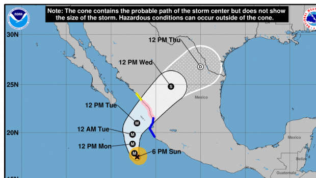
Newly formed Hurricane Willa rapidly gained force and grew into an "extremely dangerous" Category 4 storm in the Pacific off Mexico on Sunday, with a potential to make landfall on a western stretch of coast between Mazatlan and Puerto Vallarta in the coming days.
The U.S. National Hurricane Centre said in an evening bulletin that the storm was "forecast to produce life-threatening storm surge, wind and rainfall over portions of southwestern and west-central Mexico beginning on Tuesday."
A hurricane watch was posted for a stretch of shore between San Blas and Mazatlan, while a tropical storm warning was in effect from Playa Perula to San Blas. Hurricane force winds extended out 40 kilometres from the storm's core and tropical storm force winds were up to 130 kilometres out.
Willa was about 340 kilometres south-southwest of Cabo Corrientes late Sunday, with maximum sustained winds of 230 km/h. It was moving to the north-northwest at 11 km/h, but a turn toward the north was likely during the night or Monday.
The hurricane centre forecast 12.5 to 25 centimetres of rain across parts of western Jalisco, western Nayarit and southern Sinaloa states, with lesser amounts falling as it moves inland.
Meanwhile, a weakening Tropical Storm Vicente appeared to be a less potent threat farther south. Forecasters said it was expected to weaken into a tropical depression overnight, while remaining just offshore or near Mexico's southern Pacific coast through Tuesday morning.
Its core was about 370 kilometres southeast of Acapulco with top sustained winds of 65 km/h. The hurricane centre said it could produce 7.5 to 15 centimetres of rain in parts of Guerrero, Michoacan, Colima and Jalisco states.
