
First Nations woman to launch a travel app that features Blackfoot historical sites in Canada & U.S.

If you've driven down any of the highways in southern Alberta, you've likely passed by a Blackfoot historical site, such as an eagle catch, without even knowing it.
But Souta Calling Last hopes to change that.
Calling Last, who is from both the Kainai First Nation and Southern Piikani First Nation, runs an educational, non-profit organization called Indigenous Vision.
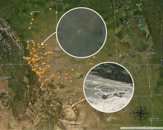
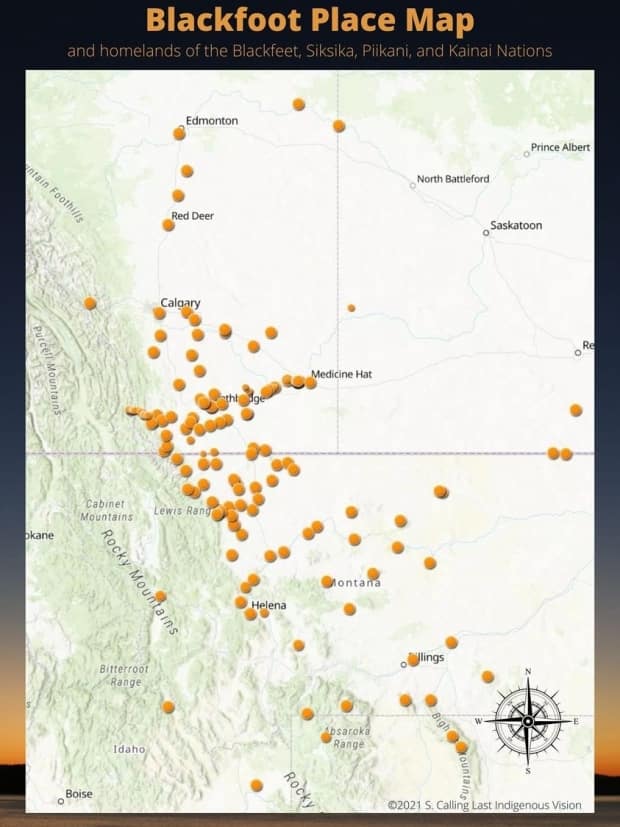
She has spent the past four years designing an interactive map depicting hundreds of Blackfoot historical and sacred sites in Alberta, Saskatchewan, Manitoba, Montana, Idaho and Wyoming.
The Blackfoot Confederacy includes the Siksika, Kainai and Piikani Nations, representing more than 23,000 members in Alberta and another 19,000 in Montana.
"The amount of history we have, we cannot walk around with our heads down, shoulders slumped, because it's just so expansive and so beautiful and so powerful," said Calling Last.
Calling Last says she sees a lot of potential uses for this map project, including teaching, city planning, environmental assessments and ecotourism.
She plans to launch a mobile app that would ping a user as they neared a historical site, and then provide an audio and/or video recording about the place with the story behind it, and in some cases, directions to get there.
For example, she says, history buffs could plot out all the Blackfoot battle sites to visit during summer vacation.
Calling Last plans to share the full interactive map with tribal leaders, cultural leaders and academics.
But she says not all of the sacred sites will be made available to the public.
"We walk that fine line of keeping a site sacred and also educating about that site so that it's not at risk from development or getting destroyed or, you know, losing the site."
Teepee rings, eagle catches
Calling Last says the Blackfoot map includes 108 dots, which represent more than 500 sites, some of which date back thousands of years.
Calling Last says each of these locations was discovered through conversations with her family, tribal elders and community members, as well as archeological surveys and studies.
"I take the source and I look for paralleling stories," said Calling Last. "Usually the way oral stories and history is handed down is each member or area or society is given a portion to remember."
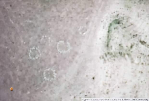
She says some items can be spotted in satellite images. In one image, a teepee ring, which is a circle of stones that holds down the canvas of a teepee, appears as a little white shadow.
Other sites, such as eagle catches, are harder to spot, she says, because they appear as nothing more than a pile of rocks and sticks and are located high up on the land.
She calls one of the two that are plotted on the map "Calling Last Eagle Catch," because it was passed down to her by her family.
She says eagle catchers were men or women. She says the catcher would dig a pit to sit in and then cover themselves up with sticks and some type of decoy such as a dead rabbit. She says that when the eagle landed, the catcher would then have to quickly grab the eagle's legs, to either pluck a feather or to harvest the whole animal.
She says the process would also include a ceremony.
"The impression I got was that it was almost a warrior's job or a coming of age type thing where you were able to go and you were trained," said Calling Last.
Calling Last says the map also includes the stories behind the names of locations such as the Crowsnest Pass, historic events, including the first fur traders location, burial grounds, petroglyphs and different band leaders.
Lived beyond the reserve
Piikani elder Harley Bastien, who worked on the map project, believes the map will help the Blackfoot people reconnect to the expanse of land they once called home before reserves were established.
"Some of the youth grew up thinking this is it, so many miles by so many miles is where we always called home, but that's the farthest from the truth," said Bastien, who is president of Indigenous Vision.
He also hopes this map will also be used to better educate Canadians about the country's pre-settlement era.
"If nothing else, [it will] give them some sort of an education that these aboriginal people didn't just generate and originate from a reserve," Bastien said.
He said their homes and highrises were "built probably on the history and the blood and bones of the Aboriginal people who lived there."
Calling Last has already worked with other First Nations communities to develop their own historical maps. In one case, it was with respect to mapping missing and murdered Indigenous women. In another, it was mapping the location of traditional pigments used in traditional pottery and painting.
She says collecting and mapping these stories and historical data allows First Nations to have sovereignty over their past, and therefore, their future.
Calling Last has provided a static version of the map to CBC News.
She is hoping to launch the app within the year.
