
Get to know the weather terms you'll be hearing about this summer
CAPE: An acronym for Convective Available Potential Energy. It is a measure of the amount of energy, or fuel, available during a developing thunderstorm. A higher CAPE value indicates an upper atmosphere that is more unstable, and therefore capable of producing a stronger updraft.
Downburst: Downbursts are powerful winds that descend from a thunderstorm. They spread out quickly and in all directions once they hit the ground. Damage caused by a downburst can be significant, on par with that of an EF0 or EF1 tornado - with wind speeds sometimes topping 160 kilometres per hour.
SEE ALSO: Heat is on the horizon. Here are 6 things you'll need to keep cool
Drought: The [Glossary of Meteorology](ght#:~:text=(Sometimes%20spelled%20drouth,activity%20that%20is%20under%20discussion.) defines drought as "a period of abnormally dry weather sufficiently prolonged for the lack of water to cause serious hydrologic imbalance in the affected area." Prolonged periods of dry weather can cause significant problems for agriculture and can elevate the risk of fast-spreading wildfires.
Dust devil: While tornados typically develop under rotating thunderstorms, dust devils materialize when there are clear skies and warm temperatures. When cold air moves aloft over the region and there is strong sunlight hitting the surface, it can cause rapid heating at the ground level, leading to a strong updraft that can pick up dust and rotate.
Visit our Complete Guide to Summer 2023 for an in-depth look at the Summer Forecast, tips to plan for it and much more!
WATCH: DUST DEVIL SPINS UP IN CHAMPION, ALBERTA
Fujita scale: The Enhanced Fujita scale, more commonly referred to as the EF-Scale, became operational in the U.S. on February 1, 2007. It went into effect in Canada on April 1, 2013, replacing the Fujita scale (F-Scale) that had been used since 1971, created by Ted Fujita.
Both scales are similar, representing different degrees of damage, but the enhanced version was established to better account for observations made during ground surveys and to more accurately correlate wind speeds with storm damage.
On the EF-Scale, tornadoes range from 0 to 5, with 5s typically being the most violent (and thankfully, the rarest).
DON'T MISS: The best sunscreens for daily use this season
Funnel cloud: A funnel cloud is associated with a rotating air column that is not in contact with the ground, unlike a tornado.
VIDEO: SASKATCHEWAN FUNNEL CLOUD | MAY 2022
Gustnado: (or Gustinado) - A gustnado is a small whirlwind which forms as an eddy in thunderstorm outflows. They are not tornadoes becuase they are not fueled by a rotating cloud. Butacn still be damaging - so if you ever see one, do not approach it.
Hail: “Hail is a type of icy precipitation that occurs in thunderstorms,” writes Weather Network meteorologist Melinda Singh. “Strong updrafts within a thunderstorm carry moisture to the top of the cumulonimbus cloud, where the moisture freezes into ice. This process continues until the hailstone becomes heavy enough that gravity takes over and it falls from the cloud.”
6" hail at the intersection of US-183 and N-96. #NEwx pic.twitter.com/v4Q0WZBA4i
6” hail at the intersection of US-183 and N-96. Dan Gottschalk on Twitter: "6" hail at the intersection of US-183 and N-96. #NEwx pic.twitter.com/v4Q0WZBA4i / Twitter" Dan Gottschalk on Twitter: "6" hail at the intersection of US-183 and N-96. #NEwx pic.twitter.com/v4Q0WZBA4i / Twitter"
— Dan Gottschalk (@dangottschalk) Dan Gottschalk on Twitter: "6" hail at the intersection of US-183 and N-96. #NEwx pic.twitter.com/v4Q0WZBA4i / Twitter"
Heatwave: A heatwave is an extended period of hot weather relative to the typical conditions of a certain location. This heat may be accompanied by high humidity as well as uncomfortably warm temperatures at night. During a heatwave event, two or more consecutive days of extreme heat occurs, which is typically 30 degrees or higher. The exact criteria however, varies across Canada.
Humidex: The humidex, or humidity index, is a toll used to describe how the weather feels to the average person when heat and humidity are accounted for. It is a dimensionless quantity, i.e., it is not measured by degrees Celsius, and it is based on the dew point.
Hurricane or Tropical Storm/Cyclone: A hurricane is a large, quickly swirling storm which forms over warm ocean waters, producing winds of 119 kilometers per hour or stronger. Sometimes, these storms strike land and when it does, it can cause significant damage. The eastern Pacific hurricane season starts May 15 and runs until November 30, although hurricanes can, and have, occurred outside of this time frame. More than one hurricane can occur at a time, and this is one reason these storms are named. Names make it easier to keep track of, and talk about, these powerful systems.
Lightning: There are three main forms of lightning. Most of us are familiar with the classic ‘fork lightning’ (cloud to ground) or ‘sheet lightning’ (cloud to cloud). But there are other, rare forms - like include ball lightning, where a white or coloured sphere of light is seen; ribbon lightning, where a lightning bolt appears to spread out horizontally in ribbons or streaks, and pearl-necklace – or chain – lightning, where the discharge of light has an appearance of pearls on a string. Ninety per cent of lightning never reaches the ground, but instead travels from cloud to cloud, otherwise referred to as ‘sheet lightning’.
RELATED: Can lightning strike the same place twice?
VIDEO: LIGHTNING STRIKES IN PORT STANLEY, ONTARIO
Muggy: “Muggy” is one of those terms you can almost feel. It’s characterized by warm and damp weather, or the hot days where the air feels especially heavy.
Severe Thunderstorm warning: When Environment and Climate Change Canada detects evidence of a severe thunderstorm based on radar, satellite imagery, or via a report from a reliable on-location source that one or more of the following three weather conditions is imminent or occurring, a severe thunderstorm warning is issued:
Wind gusts of 90 km/h or greater, which could cause structural wind damage;
Hail of two centimeters (cm) or larger in diameter; or
Heavy rainfall.
“Exactly when a warning is issued usually depends on what kind of weather is expected. For severe thunderstorms and tornadoes, the ideal goal is to follow a specific progression, of course. First a watch is issued, and this is followed by upgrading those watches to warnings as the storms or tornadoes develop," writes Weather Network science writer Scott Sutherland.
"Thus, a severe thunderstorm watch could be in effect for much of the day, and then it is replaced by a severe thunderstorm warning as the storms pop up on radar.”
Smog: Also referred to as “smoke fog,” smog is a type of air pollution, characterized by its opaque and often odorus nature. It is a type of visible air pollution consisting of car and factory emissions, as well as haze from wildfires. It gets suspended in the atmosphere when a ridge of high pressure traps cooler air below warmer, sinking air, creating a stagnant layer where particulates accumulate.
SEE ALSO: 5 simple solutions for sun protection
Squall line: A squall line is made up of active thunderstorms, either continuous or with breaks, and includes a continuous border of precipitation areas from thunderstorms.
Thunderstorm: A thnderstorm is characterized by a rain-bearing cloud that also produces lightning.
Tornado: A tornado is nature’s most violent storm, characterized by a narrow and destructive rotating column of air that extends from a thunderstorm to the ground. Tornadoes develop quickly, and they may dissipate just as fast. Most tornadoes are on the ground for only a few minutes but have the strength to cause extensive damage. The Enhanced Fujita Scale or EF Scale (see above) is used to assign a tornado a 'rating' based on estimated wind speeds and related damage.
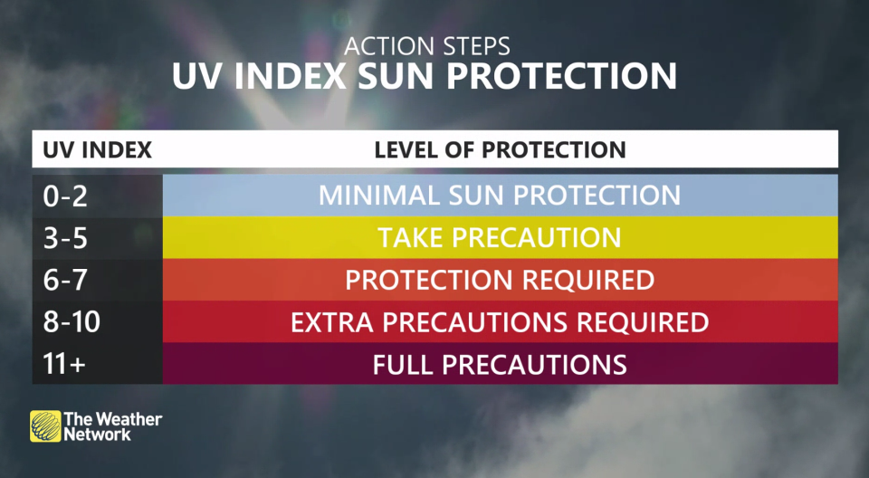
UV Index: The ultraviolet index, or UV index, is an international standard that measures the amount of UV radiation in an area at a given time. It is rated on a linear scale from 1, which represents low UV and an estimated burn time of about 60 minutes, to 11+, an extremely high rating where burns can occur in less than 15 minutes.
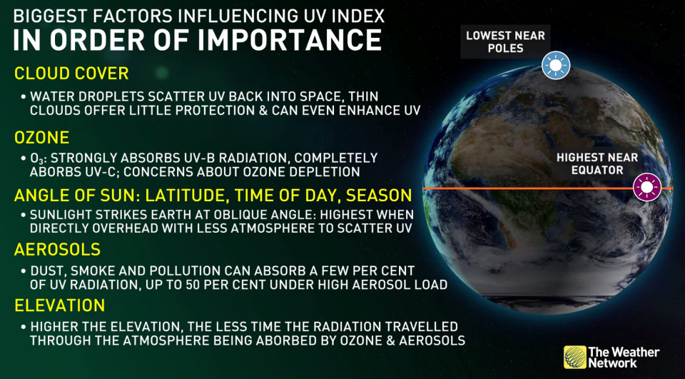
Cloud cover, angle of the sun, and aerosols in the atmosphere can influence UV levels.
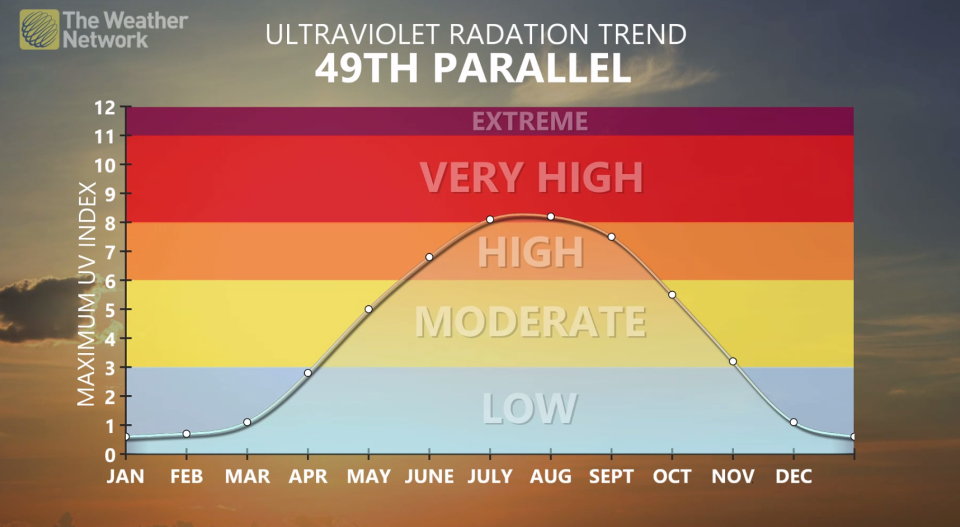
UV ratings tend to be highest in spring and summer.
Waterspout: A waterspout is a rotating column of water and spray that is formed by a whirlwind occurring over the sea or other body of water. They’re most common during the late summer and early fall.
Thumbnail: Custom by Cheryl Santa Maria using graphical elements from Canva.

