
Hurricane Zeta crashes ashore in Louisiana as a powerful Category 2 hurricane
Hurricane Zeta came crashing ashore in Louisiana Wednesday evening as a powerful Category 2 hurricane with 110 mph maximum winds and up to 11 feet of storm surge in some places.
Over the next several hours, the National Hurricane Center said the storm will bring life-threatening storm surge and strong winds from Louisiana to the Florida Panhandle.
Forecasters early Wednesday extended the tropical storm warning along the coast of the Florida Panhandle east to the Walton-Bay county line. The warning now goes from the Mississippi-Alabama border to the Walton-Bay line in Florida, with tropical storm conditions possible in the area later in the day. A tropical storm watch is also in effect west of Morgan City to Intracoastal City, Louisiana.
Hurricane conditions, including damaging winds and heavy rain, are expected Wednesday from Morgan City Louisiana to the Mississippi-Alabama border, which is under a hurricane warning. This includes at Lake Pontchartrain, Lake Maurepas and Metropolitan New Orleans.
A few tornadoes may also be possible Wednesday over southeastern parts of Louisiana and Mississippi, southern Alabama and the western Panhandle of Florida, according to the National Hurricane Center.
Zeta’s heavy rains may result in flash, urban, small-stream and minor river flooding, according to the hurricane center.
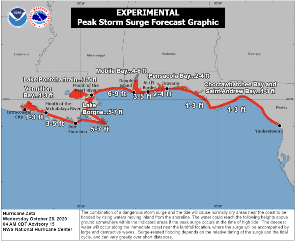
A storm surge warning is also in effect south of the Atchafalaya River to Navarre, Florida, including at Lake Borgne, Lake Pontchartrain, Pensacola Bay and Mobile Bay.
The National Hurricane Center said that the dangerous storm surge and the tide will cause normally dry areas near the coast to be flooded.
The highest storm surge, between six to nine feet, is expected from the mouth of the Pearl River to Dauphin Island, Alabama. Forecasters said other areas along the northern Gulf Coast could see from one to seven feet of storm surge including:
▪ 3-5 feet from Dauphin Island, Alabama to the Alabama-Florida border
▪ 2-4 feet from the Alabama/Florida border to Navarre, Florida including Pensacola Bay
▪ 1-3 feet from Navarre, Florida to Yankeetown, Florida including Choctawhatchee Bay and Saint Andrew Bay
From here, Zeta is expected to weaken as it moves over the southeastern United States and will eventually become an extratropical gale-force low pressure area off the Mid-Atlantic coast by Thursday night, according to the National Hurricane Center. It will then be absorbed by a frontal boundary over the western Atlantic on Friday.
The National Hurricane Center also started tracking an area of low pressure in the southwestern Caribbean. It gave the system a 20% chance of forming in the next five days and a 0% chance of forming in the next two days.

