
Major snowstorm shuts schools, halts travel across parts of Atlantic Canada
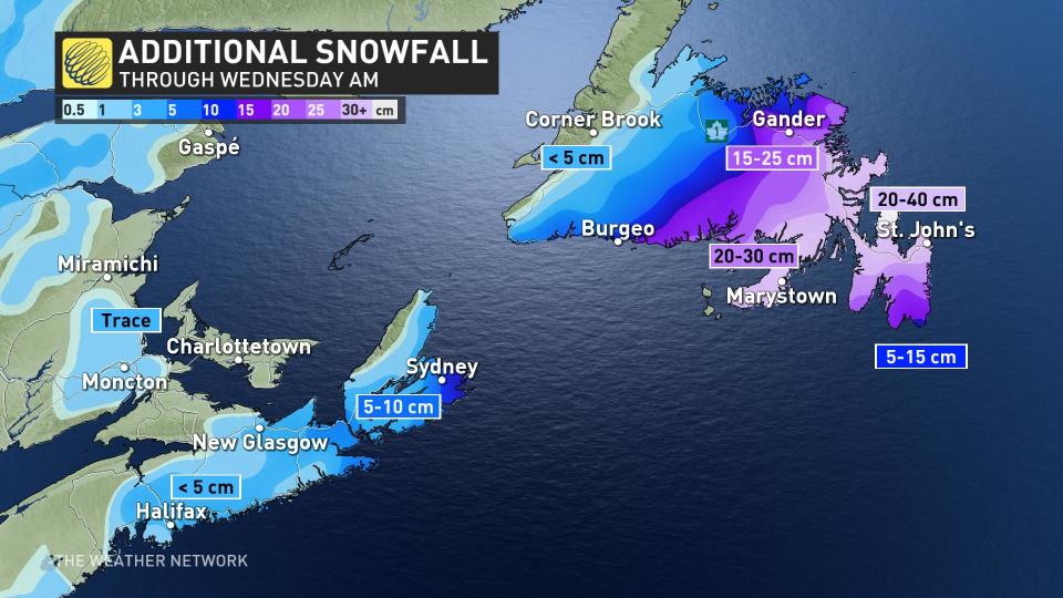
Snowfall, winter storm and blowing snow warnings remain in effect across parts of Atlantic Canada as a major winter storm delivers a potent blow for Valentine's Day. Through Wednesday morning, some areas could see between 20-40 cm of snow.
Drivers are being urged to consider postponing non-essential travel in the hardest hit areas of southern Nova Scotia and eastern Newfoundland.
DON’T MISS: It may be mild, but the snowiest months are just ahead for these parts of Canada
By the early morning hours on Tuesday, between 10-25 cm of snow had already been reported in the Halifax area. That prompted most schools to either delay their openings or just completely shut their doors first thing.
Happy Valentine's Day! Schools in #Halifax have 2 hour delayed opening @weathernetwork pic.twitter.com/mYBy6eZ1lG
Happy Valentine’s Day! Schools in Nathan Coleman on Twitter: "Happy Valentine's Day! Schools in #Halifax have 2 hour delayed opening @weathernetwork pic.twitter.com/mYBy6eZ1lG / Twitter" have 2 hour delayed opening Nathan Coleman on Twitter: "Happy Valentine's Day! Schools in #Halifax have 2 hour delayed opening @weathernetwork pic.twitter.com/mYBy6eZ1lG / Twitter" Nathan Coleman on Twitter: "Happy Valentine's Day! Schools in #Halifax have 2 hour delayed opening @weathernetwork pic.twitter.com/mYBy6eZ1lG / Twitter"
— Nathan Coleman (@NateTWN) Nathan Coleman on Twitter: "Happy Valentine's Day! Schools in #Halifax have 2 hour delayed opening @weathernetwork pic.twitter.com/mYBy6eZ1lG / Twitter"
"Heavy snow from the overnight has tapered to light flurries as of Tuesday morning for most of Nova Scotia, but lingering flurries and some blustery winds at times may still impact travel conditions," warns Kelly Sonnenburg, a meteorologist at The Weather Network.
Blizzard-like conditions threaten St. John's, NL
Across the Gulf, the nor'easter continues to move northeast across Newfoundland with some of the heaviest snow and blizzard-like conditions hitting Tuesday.
Widespread snowfall amounts of 20-40 cm are expected for the Avalon, Burin and Connaigre Peninsulas. Between 30-40 cm is expected in St. John's and 15-25 cm is forecast for Gander.
Most schools in the region opted to close their doors as well, with Metrobus pulling its drivers off the roads in St. John's. At St. John's International Airport, all flights were cancelled for Tuesday, with some early morning flights on Wednesday already cancelled as well.
The Avalon Peninsula has the highest chance to see a change to ice pellets or a mixture of freezing rain and rain by Tuesday afternoon, and that's increasingly likely for southern areas. The rain is most likely to occur along extreme southern coastal areas, with freezing rain and ice pellets farther inland.
Precipitation will change back to snow later Tuesday evening and will once again combine with strong, northerly winds to cause poor visibility in blowing snow.

Gusts may peak near 90 km/h Tuesday night into early Wednesday morning, and while snowfall rates will be winding down, the freshly fallen snow in combination with the light snow left falling will lead to whiteout conditions.
"Consider postponing non-essential travel until conditions improve," says Environment and Climate Change Canada (ECCC) in the winter storm warning for the region. "Visibility will be suddenly reduced to near zero at times in heavy snow and blowing snow."
Conditions on the island will improve on Wednesday morning as snow tapers off and winds begin to diminish.
Be sure to continue to check back for the latest forecasts for Atlantic Canada.

