
Cleanup, disruption continue after storm
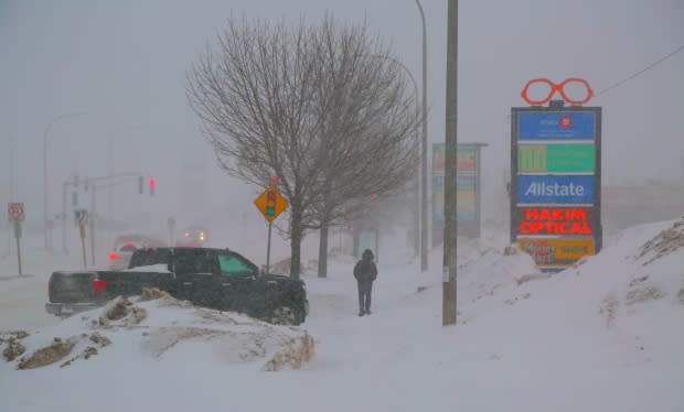
Most of the snow has been cleared away, but drivers and snowplow crews are still struggling with the ice left behind by the powerful winter blast that hit the province Sunday and into Monday.
Many highways and streets in the province remain icy or partially snow-covered, causing havoc in places, including Moncton.
Robert Labrador, who works at a business at Donald Avenue and Elmwood Drive in Moncton, said he's seen at least 14 accidents at the intersection over the past three days, the latest taking on Tuesday morning.
"The city's not doing nothing," Labrador said.
"Half the streets in Moncton are not even fit to drive on."
Jeff Scott, a general foreman with Moncton's public works department, said the cleanup from the storm — which packed snow, rain, ice pellets and strong winds — has been challenging.
"We were in good shape when the snow finished … but then when we started into the rain and freezing rain, that's when things really became a challenge," said Scott.
"Everything just turned to slush and froze up."
Scott said the cold has delayed some cleanup.
It's so cold that salt alone is not effective, he said, so the crews are using a salt and sand mix to get some traction..
But the wind is so strong the mix is often being blown off the roads.
Scott said he hopes warmer weather forecast for Wednesday will allow workers to make more progress.
Return of anchor ice
One major concern is one that will be familiar to New Brunswickers who drove last winter: anchor or armour ice.
In 2018, a layer of the ice stuck to roads after a winter storm that brought wet snow and rain, followed quickly by a drop in temperatures.
"There's a lot of snow pack and also what we call armour ice, where the ice is really just firmly bonded to the asphalt," said Scott.
"You can't scrape it off, we have to melt it off."
There is a travel advisory for the Trans-Canada Highway from Fredericton to Moncton.
The province says the highway is partially covered with snow and icy patches and travel is not recommended.
Continued closures, delays
Schools in the south and east of the province were cancelled again Tuesday because of slippery roads.
As much as 50 centimetres of snow fell in northern New Brunswick during the storm, and close to 100 millimetres of rain came down in some southern parts of the province, according to Environment Canada.
Flights from Fredericton International Airport were still being cancelled on Tuesday morning, and other flights were delayed later in the day.
A not so perfect storm
In Saint John, Mike Hugenholtz, the city's commissioner of transportation and environment services, said cleanup is well underway across the city but with "significant wet, heavy, snow that's frozen into ice," conditions are challenging.
"Our streets are pretty much blowed off but you will find a lot of anchored ice on a lot of the streets, particularly the side streets," he said. "We expect that's going to be a challenge until temperatures become a little more milder later this week.
Round two, if you will, doesn't have the strength or dynamics as our Sunday [and] Monday storm, but it will create some slippery conditions once again. - Tina Simpkin, CBC meteorologist
Hugenholtz said he's worried about heavy rainfall in the forecast for Thursday, which could be "very problematic," when temperatures again drop below freezing afterward.
"We're fearful that we might experience similar conditions as we did on Sunday evening," he said.
Scott Robinson, a project manager with Hickey Brothers DKI, a disaster cleanup company, said many people in the Saint John area are reporting flooded basements and leaking roofs, particularly in Quispamsis, which he believes was the hardest hit area.
He's advising residents to keep water and snowbanks away from their homes and keep "positive" drainage.
More snow to come
Meanwhile, Environment Canada has issued a special weather statement for the entire province.
A front will approach the Maritimes from the southwest on Wednesday and cross the Maritimes Wednesday night.
"This system will bring wind, rain and snow to the region once again," said Tina Simpkin, a CBC meteorologist.
"Round two, if you will, doesn't have the strength or dynamics as our Sunday [and] Monday storm, but it will create some slippery conditions once again."
Environment Canada said the front will usher in much milder air and strengthening southwest winds. Snow followed by rain will likely move into New Brunswick by Thursday morning, probably changing to rain by Thursday morning.
"This system may intensify during the day Thursday bringing more and significant snow melt, which could lead to potential flooding. A return to colder, drier weather is expected on Friday."
