
This new mapping tool helped Ottawa handle the 2019 floods
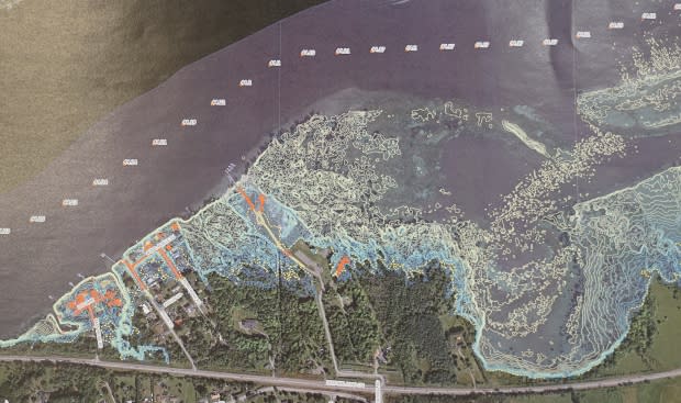
City of Ottawa officials had a new tool at their disposal during this spring's flooding: a mapping program that showed the danger each additional centimetre of water could pose to buildings and infrastructure.
Laila Gibbons, director of roads and parking services, said the predictive mapping tool contributed to the decision to declare a state of emergency after the Ottawa River Regulation and Planning Board released its forecast in late April.
"When we put [the forecast] into our mapping program to see what that was going to look like, there are some areas across the city that were actually going to see [damage] beyond the one-in-100-year or the one-percent storm," Gibbons said.
"That was a significant change to what we were seeing just two or three days before that."

Cost $160K
The mapping tool allows city staff to input different water levels and see how roads, city infrastructure and private property will be effected, Gibbons said.
It was developed over the last year and cost just under $160,000.
The program uses topgraphic LIDAR — or light detection and ranging — maps from 2015, which helped the city detect weak spots and direct homeowners, volunteers and the military where to best place sandbags.
"In 2017, we made some assumptions about where water was accessing the properties," Gibbons said.
"This time around, we were able to actually identify the real areas [where] the water was overflowing the banks and then inundating roads and properties."
Tool to go public
One of the shortcomings of the program, however, was that the 2015 data didn't take into account the protective work residents performed before, during and after the 2017 floods — like newly raised houses, for instance, or the recently-built Britannia berm.
Gibbons said the map will also have to be updated to include groundwater, which affects infrastructure further inland.
The city is working on developing a publicly accessible version of the mapping tool, Gibbons added, so people can check on their own properties.
A spokesperson for the City of Gatineau says the municipality is working with other local governments on improved mapping and communications technology for areas affected by flooding in the region.
The Quebec government announced in March 2018 it would put $2.8 million toward the development of those projects.

