
Massive change in weather patterns coming to Canada

If you live in Ontario or Quebec, you’ve likely seen a more mild winter so far this year, but experts say you should definitely start getting out your winter gear and putting on those snow tires because a huge shift in temperature is on the way as we head into December.
“Our team at The Weather Network is forecasting a dramatic reversal of the weather pattern that’s going to start next week, basically the middle of the first week of December and on,” Chris Scott, chief meteorologist at The Weather Network said.
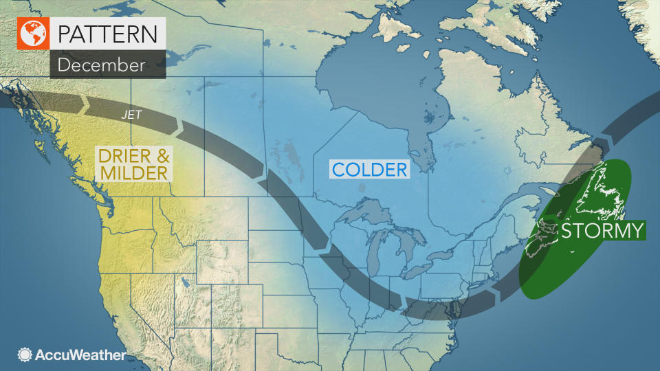
According to Scott, there is a jet stream going on a “wild ride” as we head into the later half of the week, which will go up towards Alaska, through the Yukon and then plummet down across the Prairies, into Eastern United States, and then off the East Coast. When a jet stream takes on this pattern, the air coming through Manitoba, Ontario and Quebec is coming from the Arctic, which sparks a change from fairly mild conditions to colder temperatures, and an increased chance for snowfall.
“Mother Nature doesn’t show us her hand all the time but sometimes she gives us more of a glimpse into what the cards are that she’s holding and wow, she’s giving us a great glimpse this time…and this is as confident as we ever can be talking about a forecast coming out 10, 14 plus days,” Scott said.
According to Brett Anderson, AccuWeather’s senior meteorologist, the significant change in temperature will occur around December 7, 2017 and will likely continue into the third week of December as well.
“There is going to be significant increase in lake effect snowfall in the typical lake effect snow belt, ” Andreson said. “I would say there’s going to be opportunities for accumulating snow, probably from eastern Ontario right up through the Maritime provinces to Quebec, anytime between the 7th and the 17th,” Anderson said.
Accuweather’s weather models are showing that Ontario, Quebec and Manitoba will see temperatures drop to 5 C below average, but Anderson believes temperatures could be even colder. Scott at The Weather Network says temperatures could be as low as -30 C in Northern Ontario and Manitoba by mid-December, with temperatures below freezing for highs in Southern Ontario by the end of the week.
In British Columbia, the western portion of Alberta and the Yukon, weather patterns will be completely the opposite.
“We’re going to dry out, it’s going to tranquil,” Scott said. “While everyone is going to be freezing back east, B.C. is going to be enjoying a really mild second and third week of December.”
According to Anderson, this dry pattern in B.C. will bring temperatures to roughly 2 C above normal in the province and 3-4 C above average temperatures in western Alberta in the second week of December.
“It’s also going to be much drier, little if no storms coming to that area,” Anderson said.
If you live in Central or Eastern Canada, enjoy the mild temperature before winter comes knocking at your door.
