
Treacherous travel in Alberta as snowstorm intensifies, cold will follow
A one-two punch of brutal winter weather is taking shape on the Prairies this week as a stark pattern reversal takes hold.
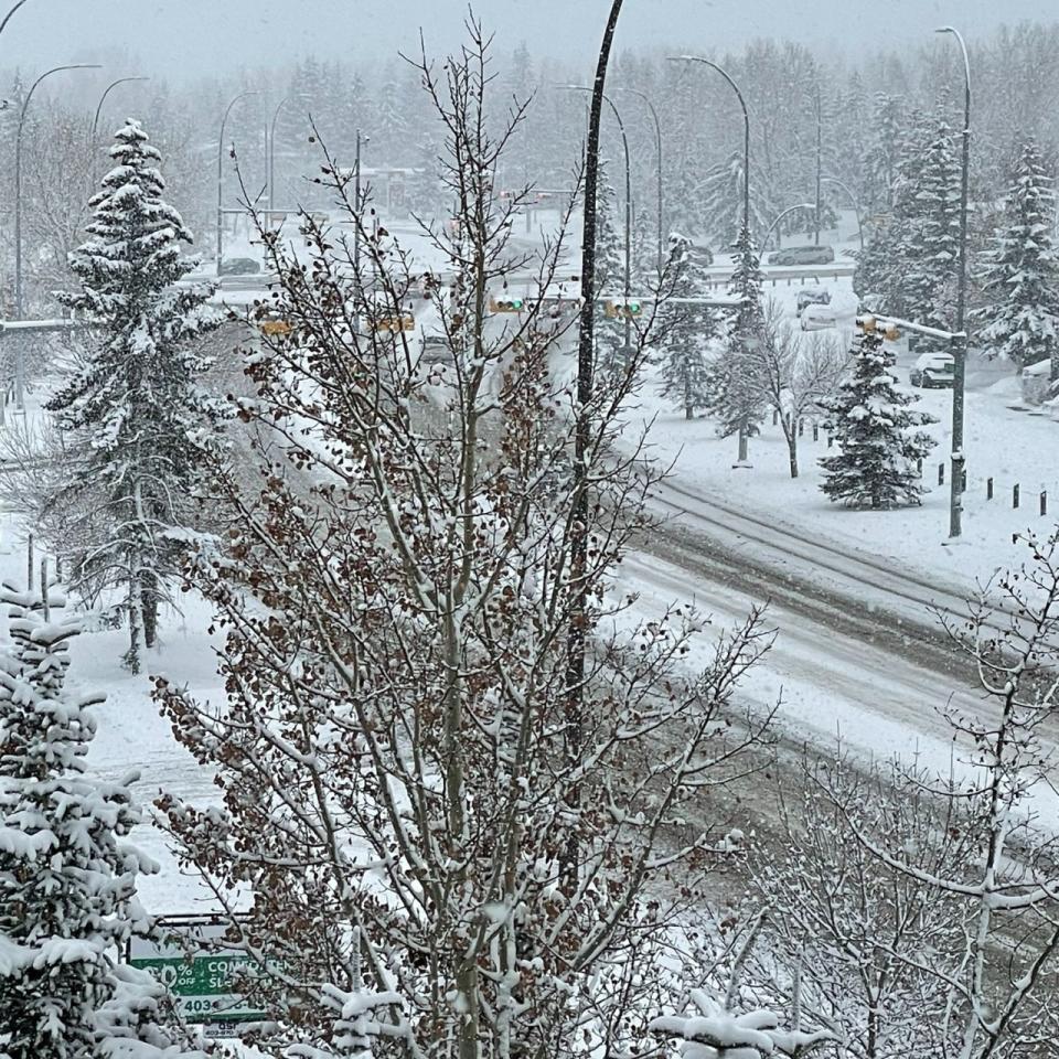
Alberta is getting to feel winter’s wrath first as heavy snow traverses the southern foothills, lasting into Tuesday. This has made travel treacherous across parts of the province, and commuters can expect the same for the Tuesday morning trek. Some areas have the potential to see 30-40 cm of snow, locally up to 50 cm.
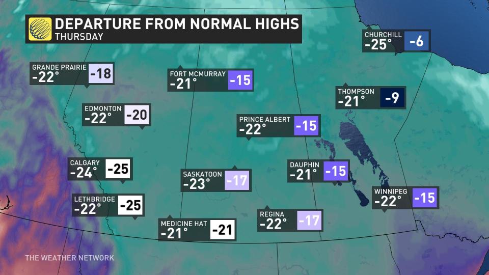
Behind the snow comes a blast of Arctic air, promising the region’s coldest temperatures since December. Wind chill values could dip into dangerous territory through the coming week. This Thursday, the high of -23°C in Calgary is 24°C below seasonal for late February, with the normal high near 1°C.
MUST SEE: Wild ride to the winter finish line in Canada, find out your fate
Winter returns with significant snow potential
A potent Arctic front slicing across eastern British Columbia and western Alberta will continue to bring heavy snow to the regions into Tuesday.
The low-pressure system has plenty of cold air and Pacific moisture to work with, a contributing factor in high snowfall totals.
After a brief break, the main event pushed in Monday afternoon. The snow increased in intensity Monday evening and continue well into the overnight hours, setting up treacherous conditions for the Tuesday morning commute.
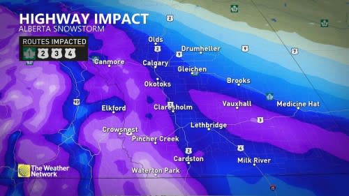
Environment and Climate Change Canada (ECCC) has issued a snowfall warning for the majority of western Alberta and urges travellers to plan ahead and to keep others informed of their travel plans, as well as carry an emergency kit and mobile phone with them at all times.
Heavier snowfall rates linger through Tuesday morning, becoming lighter in the afternoon and evening. The snow will be light and fluffy because of the Arctic air, so totals could be higher than expected.
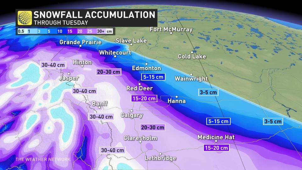
Snowfall totals will be significant across the western half of Alberta, stretching from just south of Grande Prairie to the southern border, and reaching as far east as Medicine Hat. Amounts in this swath will range from 10-40 cm, with most of it along the foothills where accumulations could reach as high as 50 cm locally.
The city of Calgary, Hinton, and Lethbridge will be right in the middle, with projections of 20-30 cm for these areas.
As a result, travel will be greatly impacted throughout the southern portions of Alberta as this push of Arctic air forces its way into the region.
Arctic air to send temperatures diving, wind chills set to return
Across the Prairies as a whole, we’ve seen a series of unusually mild temperatures for more than a month now. This stretch of consistently above-seasonal conditions will come to an end in a hurry as this push of Arctic air crashes southward.
The coldest air associated with the trough will spill across the region on Tuesday and stick around for several days before letting up a bit.
The deep chill pushing into Alberta will keep temperatures in Calgary and Edmonton firmly lodged in the minus double digits beginning Monday night and lasting through Saturday morning.
MUST WATCH: So your forecast calls for snow, but which type?
Regina and Saskatoon will see the coldest air arriving on Monday night and Tuesday. Each city will deal with several days of high temperatures in the -20s, with Saskatoon only predicted to hit -23°C on Wednesday.
Winnipeg will face Wednesday and Thursday with daytime highs only climbing to about -22°C, with overnight lows forecast to reach -30°C multiple times through the week.

While these certainly aren’t the coldest temperatures we’ve seen, it’s going to feel especially raw given that it’s been so mild on the Prairies in 2023.
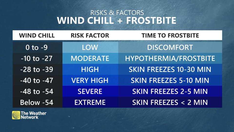
Winds certainly won’t help matters, either. Wind chill values will dip into the -30s and approach -40 for the duration of the coldest air next week, which will increase the risk for frostbite and hypothermia. Exposed skin can develop frostbite in as little as 10 minutes with wind chill values approaching -40.
This spell of cold air isn’t scurrying off anytime soon. Below-seasonal temperatures will stick around for much of the Prairies through the end of the month.
Thumbnail courtesy of Inam Jamil/Twitter.
Stay with The Weather Network for the latest on conditions across the Prairies.
