
Strong winds, messy precipitation plows through Central Canada
Ontario and Quebec's infamous flip-flopping between winter and spring weather is expected to continue into April before we can bid adieu to the former as conditions reflective of the latter will settle in.
That means wintry weather will continue for the time being, such is the case this weekend in Central Canada. Ontario and parts of Quebec saw a wide range of impacts including everything from snow and ice to rain and intense wind gusts.
ALSO READ: Texas low generates Ontario's first thunderstorm risk of the year
Southern Ontario
Parts of southern Ontario and the Greater Toronto Area (GTA) started their Saturday with freezing rain that quickly transitioned into rain as the temperatures increased throughout the day.
The low system also brought the first thunderstorm risk of the season to areas surrounding lakes Erie and Ontario. While the threat has dissipated throughout Saturday evening, the strong winds will continue to sweep through the area.
A sharp pressure gradient with this low means that accompanying this messy precipitation will accompany strong, blustery winds.
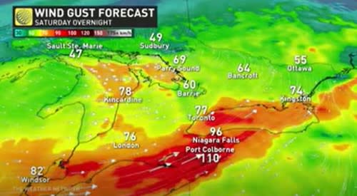
Gusty easterly winds will peak at over 80 km/h through Saturday along western Lake Ontario, then become southwesterly up to 120 km/h along the shores of Lake Erie by evening.
The winds will continue along the north and east shorelines of lakes Ontario and Erie throughout the overnight hours and into Sunday morning before diminishing throughout the day.
While temperatures begin to drop in the early evening, there may be brief periods of light flurries across the GTA, but with minimal accumulation. However, some evening snow will make roads slightly slick after a day of ice and rain.
WATCH: Miserable, stormy day in Ontario comes with a silver lining
Eastern Ontario and Quebec
Parts of eastern Ontario and Quebec saw snow sweep across the area on Saturday morning. Ottawa, Sault Ste. Marie, and Sudbury saw the brunt of the snow, with the area expected to see 15cm by midnight Saturday.
Snow will linger throughout the area during the overnight hours, an additional 1-2cm will drop over Ottawa and Montreal before departing during the afternoon on Sunday.

Environment and Climate Change Canada has issued special weather statements across eastern and southern Ontario, as well as for parts of southern Quebec for this system’s risks and impacts.
Looking ahead, Sunday will be a much nicer day in southern Ontario as there will be some sunny breaks throughout the afternoon.
DON'T MISS: TICK SEASON: 5 little-known facts pet owners should know
WATCH NOW: Get in your spring skiing while you can! Who's still open across Canada
Thumbnail courtesy of Mark Robinson
Keep checking back to The Weather Network for more forecast and weather information for Ontario and Quebec.

