
Mild winter derailed in Atlantic Canada by coldest air in nearly 20 years
The polar vortex is taking a cross-country trip this week, with Atlantic Canada getting the honour of being its final destination.
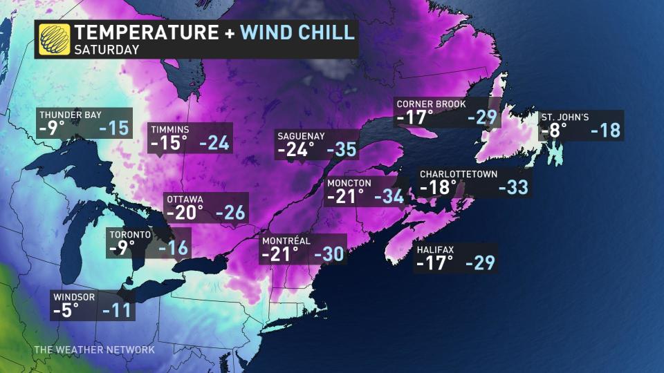
On Saturday, temperatures in Halifax, N.S., are forecast to not go above -17°C.
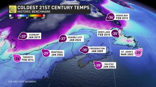
The last time it was this cold in Halifax, the price of regular gasoline was 88 cents. A lobe of the polar vortex is swirling over Hudson Bay currently. There’s high confidence that it will be directly over the Maritimes by Saturday -- an unusual trajectory for such severe cold.
MUST SEE: Polar vortex may bring Eastern Canada's coldest temperatures in years
It has been one of the mildest winters on record for a chunk of Atlantic Canada. Take January, for example, with mean temperatures above the freezing mark across Yarmouth and Sydney, N.S. Some of the warmest temperatures this winter have splashed into the mid-teens.
We have tremendous confidence in this extreme cold, with temperatures up to 40 degrees cooler than our warmest highs this winter. That means you have ample time to prepare firewood, protect outdoor pipes, alter driving and travel plans, as well as for communities to enact emergency operations for the most vulnerable.
Timing
After chilly days on Wednesday and Thursday, a surge of milder air associated with a rapidly developing frontal boundary pushes across the region.
As the low-pressure system lifts across Newfoundland, an Arctic front readily moves across the area on Friday. Arctic fronts often generate powerful frontal squalls, so localized whiteouts are possible as this convective feature crosses the Maritimes.

By Saturday morning, the temperature will have plunged 30 degrees in spots.
Peak cold
Saturday morning will feature the worst of the brutal cold, with temperatures in the -30s across New Brunswick and well into the -20s across Nova Scotia and Prince Edward Island.
Temperatures in Newfoundland will likely remain above -20°C for the most part but will plunge to below -40°C for inland Labrador.
Extreme wind chills
The model guidance has revealed a dangerous red flag.
The low-pressure system that lifts north likely meets the criteria for bombogenesis, dropping well over 24 hPa of pressure in 24 hours. It's rare to have the polar vortex and a rapidly deepening low colliding over the Maritimes.
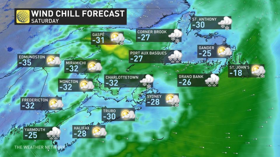
Consequently, it fuels wind chills into the -40s across some inland locations in the region.
WATCH: How to layer properly in extreme cold
Frost quakes
After 183 mm of rainfall across Halifax, the fourth rainiest January on record for the city, the rapid freeze of the saturated soil will make it more common for cryoseisms (frost quakes) -- a seismic event caused by sudden cracking action of the ground.
These initiate from the rapid expansion of ice associated with rapid temperature swings. An added risk includes the lack of snowpack across the region, which will fail to insulate the ground.
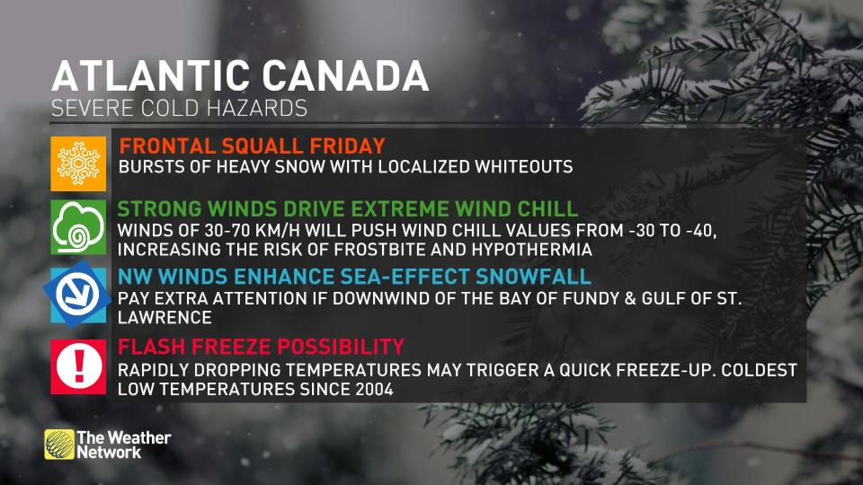
Although often alarming, there is no danger to the public. bBut the thundering and booming sounds are often startling, as they tend to occur in the evening and overnight.
Sea-effect snow
When the cold air mass settles over the region, potent sea squalls will initiate over the Bay of Fundy, the Northumberland Strait and much of Newfoundland.

Water temperatures are running above average, whichc will enhance the snow squalls and the potential for whiteouts.
Quick reprieve
As fast as the temperatures plunge, they will warm up just as rapidly. By Sunday, a milder flow off the Atlantic Ocean takes hold, driving temperatures up to near the freezing mark along coastal Nova Scotia.
With files from Tyler Hamilton, a meteorologist at The Weather Network.
Be sure to check back for the latest weather updates across Atlantic Canada.

