NASA Tracks Super Typhoon Haiyan From Space (Photos)
A NASA satellite has been keeping an eye on Super Typhoon Haiyan as the monster storm pounds the Philippines with torrential rain and the most powerful winds seen in a generation.
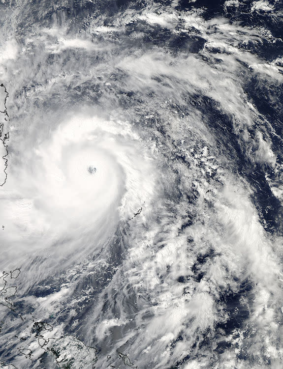
The space agency's Aqua satellite passed over Super Typhoon Haiyan as the cyclone neared the Philippines recently. Aqua's Moderate Resolution Imaging Spectroradiometer instrument, or MODIS, snapped a photo of Haiyan at 12:25 p.m. local Philippine time on Nov. 7 (11:25 p.m. EDT on Nov. 6).
The image shows the broad bands of thunderstorms surrounding Haiyan's eye, as well as the weather systems lashing the Philippines in the early morning hours of Nov. 7 (U.S. EDT time), NASA officials said. [8 Terrible Typhoons]
Meanwhile, another Aqua instrument — the Atmospheric Infrared Sounder (AIRS) — gathered infrared data on the typhoon, measuring temperatures at Haiyan's cloud tops and at the surface of the sea.
"The infrared data revealed a sharply defined eye with multiple concentric rings of thunderstorms and a deep convective eyewall," NASA spokesman Rob Gutro, of the agency's Goddard Space Flight Center in Greenbelt, Md., wrote in a description of the Aqua observations.
"The infrared data showed cloud top temperatures as cold as 210 degrees kelvin/-81.67F/-63.15C/ in the thick band of thunderstorms around the center," Gutro added. "Those cold temperatures indicate very high, powerful thunderstorms with very heavy rain potential."
Haiyan has developed into the most intense storm of 2013. It features sustained winds of 200 mph (320 km/h) and gusts up to 230 mph (370 km/h) — the fastest seen since 1979's Super Typhoon Tip, the most powerful tropical cyclone on record.
Haiyan is known as a typhoon (or super typhoon) because it formed in the Northwest Pacific. Such storms are called hurricanes in the Atlantic and Northeast Pacific, and cyclones in the South Pacific and Indian Ocean region, according to the U.S. National Oceanic and Atmospheric Administration.
Super Typhoon Haiyan is equivalent to a Category 5 hurricane, NASA officials said.
"The U.S. National Hurricane Center website indicates that a Category 5 hurricane/typhoon would cause catastrophic damage: A high percentage of framed homes will be destroyed, with total roof failure and wall collapse," Gutro wrote. "Fallen trees and power poles will isolate residential areas. Power outages will last for weeks to possibly months. Most of the area will be uninhabitable for weeks or months."
Haiyan is moving west-northwest at about 25 mph (40 km/h), whipping up waves with heights of 50 feet (15 m) or so. After passing through the Philippines, the storm is expected to come ashore in Vietnam, NASA officials said.
Follow Mike Wall on Twitter @michaeldwall and Google+. Follow us @Spacedotcom, Facebook or Google+. Originally published on SPACE.com.
Copyright 2013 SPACE.com, a TechMediaNetwork company. All rights reserved. This material may not be published, broadcast, rewritten or redistributed.


