
Nearly 40 homes evacuated in municipality of Riverdale amid fears Rivers Dam will fail

Homes along the Little Saskatchewan River were evacuated Wednesday night because of concerns about the structural integrity of the dam in Rivers, Man., after what Manitoba's infrastructure minister called a "one in 1,000 year flood event."
The decades-old structure was deemed up to par during its most recent monthly inspection in June, but it wasn't built to handle the kind of weather event that this week slammed the Westman region in the southwest of the province.
"I don't think anybody could have conceivably anticipated this much water coming at us. And it came at us at an incredibly fast rate," Minister Ron Schuler said at a news conference Thursday afternoon.
He said some regions got more than 200 millimetres of rain in the past 72 hours.
Schuler said 80 people in total have been moved from their homes in the flood zone. Some were also able to move livestock from the area that could be flooded if the dam, built in 1959, breaks.

Hours after the evacuations, people downstream of the Rivers Dam are watching anxiously to see if the structure will withstand the water building up over the last few days, said Todd Gill, mayor of the municipality of Riverdale, which includes Rivers.
"People are literally right on site, 24 hours a day, monitoring and studying this structure, because it's got a wall of water behind it that nobody has ever seen before," Gill said.
Schuler said engineers on site have trailers with spotlights to watch the spillway for any signs of trouble.
The province also sent 11 standard emergency response trailers, which included water pumps and water tubes, to the Westman area.
Evacuating 'out of an abundance of caution'
The province recommended the evacuation on Wednesday evening "out of an abundance of caution," Schuler said.
That recommendation was made based on assessments from two consulting firms and the province's own engineers, who identified water seeping around the spillway and lost confidence when they were no longer able to see its bottom.
WATCH | Infrastructure Minister on why province asked people to leave their homes:
"We still hope that the structure will hold itself in place," he said. "It's not that we feel the structure is going to collapse imminently."
The Rivers Dam is still intact, but Manitoba Infrastructure will be monitoring it at all times until the water levels subside, a provincial spokesperson told CBC News at about 4:45 p.m. local time.
The dam is receiving ongoing "minor repairs" when needed, the spokesperson said, adding that the full damage cannot be assessed until water levels go down.
Gill said he and other officials were up until close to 5 a.m. Thursday helping to evacuate 38 homes after heavy rain washed out roads, flooded streets and homes and significantly increased water levels in the area, which is about 220 kilometres west of Winnipeg.
Twenty-one people are staying at the Blue Crescent Hotel in Rivers, while 59 opted to stay with family or friends on higher ground.
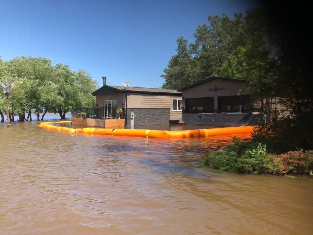
So far, only one home has been lost to the water — and it was Gill's.
He said a crew of about 50 people were helping build a dam early Wednesday morning, but the water overcame the dam, "so we had to call it."
"That's the way it goes," Gill said. "The water has risen well beyond anyone's imagination, and we did what we could."
He said the town is hoping the water recedes without any other incident.
Lake Wahtopanah, also known as the Rivers Reservoir, is the lake held back by the Rivers Dam. From Sunday afternoon to Tuesday evening, Gill said the water level jumped nine feet.
"It's unprecedented," he said.
The province is recommending all use of Lake Wahtopanah be stopped immediately, Schuler said.
WATCH | 'Unprecedented' water level on Lake Wahtopanah:
Flood passes 2011 record levels
The flooding this week has surpassed many of the previous record levels set during the 2011 flood in Manitoba.
During that event, the flow over the spillway at the Rivers Dam was 5,000 cubic feet per second, while it's now more than doubled to 12,000 cubic feet per second, Schuler said.
Meanwhile, the water level at Lake Wahtopanah is 4.3 feet higher than it was in 2011.
"In that region, 2011 was sort of a benchmark," he said. "I think we can say with a certain amount of confidence this is far greater of an event than 2011."
Schuler said while the province doesn't expect any more significant rain, the current flow level is forecast to remain the same for the next three to four days.
He said the province is acting cautiously and has been in touch with municipalities across southern Manitoba, including Winnipeg, though the flooding is not expected to reach the city.
"Our advice is this: Out of an abundance of caution, put together your emergency measures teams," Schuler said.
At noon Wednesday, the flow of the Little Saskatchewan River at the Rivers Dam was 12,000 cubic feet per second, a provincial spokesperson said.
They noted the average flow there for this time of year is roughly 300 cubic feet per second.
State of emergency in Neepawa
About 80 kilometres east of Rivers, the town of Neepawa has declared a local state of emergency because of high water levels along the Whitemud River.
As of 4 p.m. Wednesday, that declaration was isolated to the northeast and southeast regions of the community, the town posted on Facebook.
Schuler said the province is monitoring dams in other nearby regions, including Minnedosa, and will announce if anything significant changes.
A flood warning has been issued for the Whitemud River, he said, adding that flood warnings for the Little Saskatchewan River and Whitemud River watersheds remain in place. A high water advisory for the Spruce Woods Provincial Park area is also still in place.
Operation of the Portage Diversion, a 29-kilometre channel that provides flood protection by diverting water from the Assiniboine River northward into Lake Manitoba, started early Thursday morning to limit flows in the lower Assiniboine to 10,000 cubic feet per second, Schuler said.
It's not expected to affect Lake Manitoba, which has a water level in the middle of its desired range at 811.5 feet.
A photo shared on social media Wednesday shows community members in Neepawa standing in knee-deep floodwater as they gather to sandbag.
The province has not heard any concerns that people congregating to sandbag and help with other types of flood relief could lead to the spread of COVID-19, Manitoba Health Minister Cameron Friesen said at a news conference where he discussed COVID-19 recovery plans Thursday morning.
All provincial staff on site are following measures that are in place to slow the spread of the illness caused by the new coronavirus, and social distancing will be in place at any evacuee gathering centres, Schuler said.

