
Kingston, Brockville area now under flood warning
Communities along another major local waterway are now under a flood warning, with the St. Lawrence River and Lake Ontario potentially rising until June.
Late Wednesday morning, the Cataraqui Region Conservation Authority, which covers an area roughly from Napanee to Brockville, issued a flood warning for the St. Lawrence River and Lake Ontario.
It said water levels in Kingston and Brockville are about 30 centimetres short of where they peaked in 2017, when flooding damaged docks and shorelines and led to roads being closed.
It's warning residents to be ready for waters that could keep rising into June if enough rain falls, and says there's a 50/50 chance of local levels on Lake Ontario rising another 20 centimetres or so by the end of May.
Winds gusting above 50 km/h Thursday night could cause waves that can temporarily push water higher, the authority said.
Quinte Conservation to the west and South Nation Conservation to the east each have flood watches in place, one step below a warning.
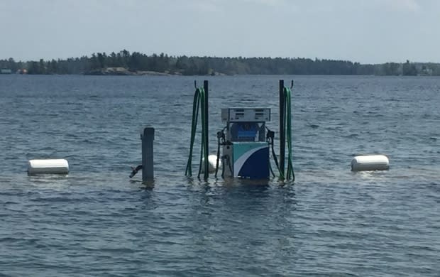
Belleville has closed two streets near Meyers Pier and cancelled an event at nearby Victoria Park over the long weekend because of the water forecast.
There are seven locations in Prince Edward County where residents can pick up sandbags if they believe their property is at risk.
After days of dropping around the capital, Ottawa River water levels are likely to rise again over the next few rainy days, mirroring what's been happening upriver.
River could rise again
The Rideau and Mississippi Valley conservation authorities warned Tuesday about the possibility of a rising river in the Britannia and Constance Bay areas, with potentially 30 millimetres or more of rain in the forecast.
"They're stable now and they may increase as a result of the forecasted rain coming on Thursday and Friday," said Brian Stratton, the Rideau Valley Conservation Authority's manager of engineering services.
It's hard to know how much water levels will climb, he said, because there is a lot of variability in the forecasted amounts of rain and still a lot of snow in the northern part of the watershed.
Forecasters have previously said the river would remain high for weeks, and residents have been warned not to dismantle sandbag walls yet.
"We're just telling people to be prepared," said Stratton.
Downstream in Ottawa's Cumberland community, as well as Clarence-Rockland, Ont., and Alfred and Plantagenet, Ont., the conservation authorities said the rain is not expected to raise water levels.
New peak
Upstream to the west of Ottawa, meanwhile, water has been steadily rising again around Pembroke, Ont., where it climbed to a new peak of 113.47 metres above sea level on Tuesday, according to the Ottawa River Regulation Committee.
The levels started going back up there last Thursday and Friday, when waters in the capital started to drop.
The river is expected to continue to rise in Pembroke and areas further upriver until Thursday, when it could hit a forecasted peak of 113.6 metres above sea level.
It also started rising again at Lac Coulonge and Lac Chats, between Pembroke and Ottawa, around Sunday or Monday.
Lac Coulonge was at 108.8 metres above sea level on Tuesday and could peak Friday at 109.15 metres, which would also be a new high-water mark.
Lac Chats, in the Arnprior, Ont., area, is not expected to reach the 76.31 metres it did on April 30.
From Ottawa down to Hawkesbury, Ont., the river has been falling for about a week and has dropped between 27 and 52 centimetres since its peak.
