Record Arctic Storm Melted Sea Ice
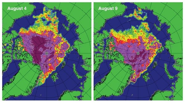
Months before Hurricane Sandy hurled the Atlantic Ocean into houses and cities along the East Coast, another record-breaking cyclone battered North America, helping push this year's Arctic sea ice to a record low, a new study finds.
Arctic sea ice has been declining for decades, reaching a record low in September 2007 and hitting that record again in 2012.
"The Great Arctic Cyclone of August 2012" arose in Siberia on Aug. 2 and crossed the Arctic Ocean to Canada, lasting an unusually long 13 days. The cyclone hit a pressure minimum of 966 millibars on Aug. 6, the lowest ever recorded for an Arctic storm, professors Ian Simmonds and Irina Rudeva of the University of Melbourne in Australia report in the Dec. 15 issue of the journal Geophysical Research Letters. The pressure reading is only 26 mb higher than Hurricane Sandy's record low of 940 mb. (A typical low-pressure system usually hits around 1,000 mb.)
"This pressure minimum and cyclone longevity are very atypical of Arctic storms, particularly in August," the authors write in the study. "We conclude that [the storm] was the most extreme August Arctic cyclone."
In terms of key properties, including pressure and radius, the Arctic cyclone ranks 13 out of all 19,625 Arctic storms on record since 1979, Simmonds and Rudeva report. "This storm truly deserves the title of 'The Great Arctic Cyclone of August 2012'," they said.
Impact on sea ice
Simmonds and Rudeva report that the storm greatly affected the record low sea ice in the Arctic this September.
"[A]nalyses we have conducted indicate [the storm] caused the dispersion and separation of a significant amount of ice, while its removal left the main pack more exposed to wind and waves associated with [the storm], facilitating the further decay of the main pack," they write in their report.
Scientists with the National Snow & Ice Data Center in Boulder, Colo., agree, saying that thinner Arctic sea ice cover this summer made the ice more vulnerable to weather. "Because the ice was thin and already decaying by the time of the storm, it was quickly broken up and melted by winds and waves," they write in an October report on record-breaking Arctic summer.
The storm cut off a large section of sea ice north of the Chukchi Sea near Alaska and pushed it south to warmer waters that made it melt entirely, NASA said in a statement published Sept. 19. It also broke vast extensions of ice into smaller pieces more likely to melt, NASA said.
Frigid storms
Every year, there are thousands of cyclones in the Arctic, some with hurricane-force winds. Unlike typical hurricanes, however, these storms tend to be smaller and are shorter-lived. [Infographic: How, When & Where Hurricanes Form]
However, other than the August storm, the weather pattern in 2012 does not appear to have been as favorable in promoting sea ice loss as in 2007, according to the National Snow & Ice Data Center.
Early summer storms over the central Arctic can bulk up sea ice, studies have found. The low-pressure systems create a wind pattern that keeps the ice in colder water, and the storms can bring cool temperatures. Conversely, in years when the weather in the Arctic is calm, more ice is lost by the end of the Arctic summer.
Weather during 2012 was near average, with the exception of the August storm, the data center said. In contrast, the summer of 2007 — the last sea ice record low — featured warm southerly winds along the shores of the East Siberian and Chukchi seas, favoring strong ice melt in these sectors and pushing the ice away from the coast, leaving open water.
Reach Becky Oskin at boskin@techmedianetwork.com. Follow her on Twitter @beckyoskin. Follow OurAmazingPlanet on Twitter @OAPlanet. We're also on Facebook and Google+.
Copyright 2012 OurAmazingPlanet, a TechMediaNetwork company. All rights reserved. This material may not be published, broadcast, rewritten or redistributed.


