
Few Saint John residents heed voluntary evacuation notice, despite record flood projections
Few Saint John residents are heeding a voluntary evacuation notice, despite record flood predictions, according to officials.
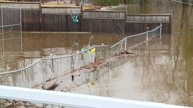
Water levels in the city reached 5.2 metres on Wednesday and are expected to rise to 5.8 metres by Friday, exceeding last year's historic peak of 5.76 metres, says the local Emergency Measures Organization.
As of late Wednesday afternoon, only about six families had fled their homes and registered with the Red Cross, said Bill Lawlor, provincial director of the organization. But he expects the number of evacuees to increase in the coming days.
Dot Delaney, 68, whose house on the city's west side is already surrounded by water, said she and her husband, Tony, 78, are staying put for now, hoping the forecast is wrong.
Last year's flooding filled their Penny Roadway basement almost to the ground floor, causing tens of thousands of dollars in damage, including to the electrical panel, hot water heater and countless possessions, she said.
"If it stays this way, you know, it can go up a little bit higher and we won't be in dire straits and we won't have to move out, I hope," Delaney said.
"But if it gets really windy and the waves start pounding against the house … we'll probably have to move out for a few days — not like nine weeks last year."
Best to evacuate early
Across the province, flooding has forced 491 people from 185 households so far, according to the Red Cross.
Residents in the Saint John flood zones who choose to ignore the voluntary evacuation notice issued Monday and remain in their home should be aware of the risks, EMO said in a statement.
"They may not be able to access essentials like food, medicine and water for several days, and emergency response will be delayed" because of flooded roads, it said.

"It is best to make a decision to self-evacuate early, and during daylight hours."
A voluntary evacuation notice has been issued for Randolph Island (Milford), Ragged Point Road and South Bay, along the Westfield Road between Gault Road and Grenville Lane.
But Saint John EMO director and fire Chief Kevin Clifford said it could be extended to other areas in the coming days.
In neighbouring Grand Bay-Westfield, Mayor Grace Losier is worried about her constituents.
"You know you've got people there that are 85 years old," she said. "They just simply cannot do it, you can't even get to your house — a canoe is what they are using to travel back and forth.
"Of course, there's no mandatory evacuations for flooding. So you know it's all voluntary and people are afraid to leave their houses and that leaves you afraid for people."
Soldiers assisting
Residents who do leave their homes should register with the Canadian Red Cross by calling 1-800-863-6582 or visiting the reception centre at the Carleton Community Centre, at 82 Market Place West, between 8 a.m. and 8 p.m.
The reception centre also serves as a place to make arrangements for accommodations, get information, charge electronics and receive other support services as required.
Three members of the military will be joining Saint John police officers and firefighters in conducting wellness checks and emergency response in flood-impacted areas.
City crews were busy Wednesday, temporarily building up Westfield Road near Mellinger Crescent to maintain access for about 1,315 people in the area. Access from the south has already been lost.
A single lane is now open to local traffic, the city posted on Twitter around 7 p.m. Weight restrictions on the road have been reduced to 10 tons, the city said.
Motorists should reduce their speed and drive with caution in the area.

EMO is also urging residents to stay off the railroad tracks along Westfield Road. Some people have been seen walking the tracks, which remain active with daily freight trains to and from the city.
In Grand Bay-Westfield, crews were scheduled to begin temporarily building up Nerepis Road, near civic address 150 and in the area of Westfield Elementary School, at noon to ensure regular and emergency traffic can pass as water continues to rise over that section.
Motorists are advised to expect delays during and following construction.

Road closures include:
Westfield Road near the Gault Road intersection.
Westfield Road at civic #1338 near Grenville Lane.
Lawrence Long Road near the end.
Dominion Park Road at Tippett and Green Head.
Park Road at Tippett Drive.
Tippett Road at civic #663 near Dominion Park.
By Road #7 at civic #51 near the end.
Beach Road.
Bravo Landing, the Millidgeville Ferry entry.
Farry Cove Lane near the end.
Ragged Point Road near the beach at the end.
Anyone who ignores or moves barricades can be charged and face a fine of $172.50, said EMO.
Driving on water-covered roads puts motorists in danger, as well as any first responders who may be called to assist them, the notice said.
The water may be deeper than it appears and conceal sinkholes or other damage and debris.
In addition, driving through water can create waves that may cause serious damage to nearby homes.
Belleisle Regional High School and Belleisle Elementary School both closed at 2:30 p.m. because of flooding, said Anglophone South School District officials.
Some bus routes may also be altered or delayed by flooding, they said.
