
Sask. has largest area of 'extreme fire risk' in country: Natural Resources Canada
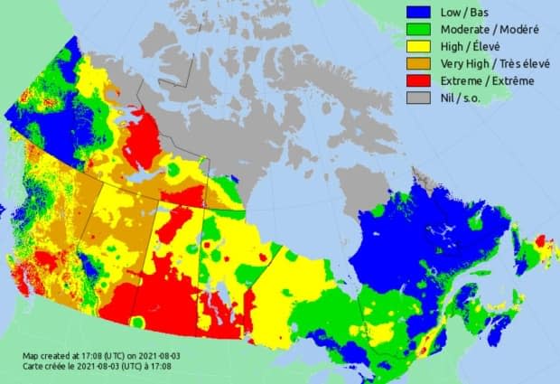
Saskatchewan leads the country in terms of area that is considered to have an 'extreme fire risk,' according to a map generated by Natural Resources Canada.
As of 12 p.m. CST on Tuesday, most of the province had an extreme risk of fire.
The affected area covered almost all of southern and central Saskatchewan, and much of the north.
At midday, most of the province's 129 active wildfires were in the Northern Saskatchewan Administration District, especially in the northeast.
The Saskatchewan Public Safety Agency said there were 18 fires that crews were trying to contain, but were expected to grow.
Latest evacuations related to smoke
An official with the Canadian Red Cross in Saskatchewan said that as of noon Tuesday, the organization was assisting 150 new medical priority evacuees from Grandmother's Bay and Hall Lake who left for La Ronge and Prince Albert over the weekend because of wildfire smoke.
Most of the estimated 1,800 evacuees forced to leave their homes in the province's north last month had since returned home.
The air quality in some central and southern regions was also being affected by the fires Tuesday.
By noon, residents of Prince Albert had already seen conditions that were rated as a 'very high risk' to people's health, according to Environment and Climate Change Canada's Air Quality Health Index.
Meanwhile, the air quality in Regina Tuesday morning was considered 'high risk' at times.
Fire restrictions left up to municipalities, parks
As of noon Tuesday, there was no province-wide fire ban in Saskatchewan, but more than 200 rural municipalities, urban municipalities and provincial parks had restrictions.
There was also a fire ban in Grasslands National Park — but not in Prince Albert National Park.
On Monday, Winnipeg-based firm Weatherlogics reported that at least 22 Saskatchewan communities had a July that ranked among their top five hottest on record. Weatherlogics compiles and analyzes figures from government weather stations.
For Hudson Bay, Wynyard and Last Mountain, last month was their hottest July ever, the company said.
Meanwhile, Weatherlogics said at least 10 Saskatchewan communities had a July that was among their top five driest on record — including Prince Albert, Melfort and Nipawin, which had their driest July ever.
Saskatoon had its fourth-hottest July and its eighth-driest, it said.
The company said last month was the fifth-hottest and 25th-driest July for Regina.
