
Southwest Volcano Threat Overlooked
More than 1,400 volcanoes dot the Southwestern United States. At least three erupted in the past 1,000 years, which is practically yesterday in geologic time. Experts and disaster officials are finally looking at the potential threats.
Though many of the region's volcanoes lie in remote corners, puncturing rainbow-hued rocks and surrounded by empty desert, some run smack up against growing Western cities.
To stay ahead of any surprises Mother Nature may be brewing underground, the U.S. Geological Survey recently brought together emergency planners and volcano experts for a conference on volcanic hazards in the Southwest. The Oct. 18 meeting marked the first time both groups had discussed their roles should an eruption occur.
"We need to get people aware of who the local experts are so we can respond more rapidly in the future," said Jacob Lowenstern, one of the conference organizers, and USGS scientist-in-charge at the Yellowstone Volcano Observatory.
Low risk, big impact
Compared to Alaska or Hawaii, the states of Arizona, Colorado, New Mexico, Nevada and Utah face a low risk of eruption.
"We don't expect a volcanic eruption anytime soon in the Southwest," Lowenstern told OurAmazingPlanet. On the other hand, dangers lurk; for example, very young lava sits just up the road from Flagstaff, Ariz. "These eruptions do occur on a human time scale. Because one hasn't happened in historical times, people aren't aware it's really possible,” Lowenstern said. “But it is.”
Low risk, however, doesn't mean low impact. If an eruption occurred, it could cause significant damage. The extent of the damage would depend in part on the character of the eruption, with volcanoes and volcanic fields (cones and lava flows) in the region varying by lava type.
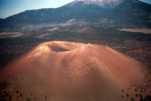
Highly fluid basalt formed the hundreds of cinder cones and lava flows tourists see dotting the Colorado Plateau. Their legacy includes one of the world's longest lava flows, as well as the repeated damming of the Grand Canyon. Rhyolite lava, on the other hand, is sticky and more explosive, and created the great Valles Caldera. Other volcanoes sometimes spew out both types of lava, such as the tall San Francisco Peaks stratovolcanoes.
In the near-term, the most likely blast scenario is a small basaltic cone, similar to Sunset Crater in Arizona or Eyjafjallajökull in Iceland, according to research presented at the meeting.
Stephen Self, a volcanologist with the U.S. Nuclear Regulatory Commission, laid out a possible scenario in his meeting abstract. A Sunset-style eruption could last months to years. Ash clouds could reach altitudes of up to 60,000 feet (16 kilometers) above the volcano, spreading hundreds of miles downwind. Ash fall-out would be 4 inches (10 centimeters) thick over an area of 200 square miles (500 square km), with thinner deposits over wider areas. [50 Amazing Volcano Facts]
Top 10 volcanoes
No state in the Southwest is immune from the hazard — the USGS ranks volcanoes or volcanic fields with moderate to high threats in every Southwestern state, from Nevada out to Colorado. The rankings account for prior eruptions and proximity to cities and transportation routes. (California was excluded from the meeting and the following list because the state has its own volcano observatory.)
The top 10 volcanoes or volcanic fields currently on watch in the Southwest are:
Black Rock Desert volcanic field, Utah: Moderate
Carrizozo volcanic field, NM: Very Low
Dotsero volcano, Colo.: Moderate
Markagunt Plateau volcanic field, Utah: Low
San Francisco volcanic field, Ariz.: Moderate
Santa Clara Volcano, Utah: Very Low
Steamboat Springs, Nev.: High
Uinkaret volcanic field, Ariz.: Very Low
Valles Caldera, NM: Moderate
Zuni-Bandera volcanic field, NM: Very Low
Tracking the threat
The conference also examined ways to better track potential hazards, Lowenstern said. For example, the Southwest has a seismic monitoring network, but it's not set up detect the subtle quivers of magma moving underground. To track a volcano’s earthquake activity, scientist typically install four to eight seismometers nearby. Researchers might also map ground deformations by satellite.
The science of desert volcanoes continues to evolve, as new dating and remote-sensing techniques improve knowledge of the area's geologic history.
"It seems like even in the last, just two or three years, work has been done on many volcanoes where folks have come up with new dates and new pieces to the puzzle," said David Ramsey, a geologist at the Cascades Volcano Observatory, based in Vancouver, Wash., who attended the meeting.
Reach Becky Oskin at boskin@techmedianetwork.com. Follow her on Twitter @beckyoskin. Follow OurAmazingPlanet on Twitter @OAPlanet. We're also on Facebook and Google+.
Copyright 2012 OurAmazingPlanet, a TechMediaNetwork company. All rights reserved. This material may not be published, broadcast, rewritten or redistributed.
