
Spring storm: Blizzard conditions drop up to 50 centimetres of snow

Drivers were urged to stay off several stretches of highway in central and western Newfoundland and Labrador Friday night, as a winter storm dumped snow, freezing rain and winds over much of the province.
The province's Department of Transportation told drivers Friday afternoon to avoid travel between Gander and Grand-Falls Windsor. It said the highway was slushy and slippery while high winds were reducing visibility. It said to use caution on most other stretches.
Equipment was taken off sections of Highway 430 between Gros Morne National Park and Plum Point, and the Burgeo Highway was also closed. In Labrador, Highway 510 between Red Bay and Lodge Bay was closed.
Schools were closed in many areas of Newfoundland Friday as some regions deal with a spring blizzard, while the Avalon Peninsula faced rain, wet snow and strong winds.
Weather warnings and statements were in effect for much of the island on Friday, as two low pressure weather systems moved in from the north and south.
Avalon, Burin peninsulas
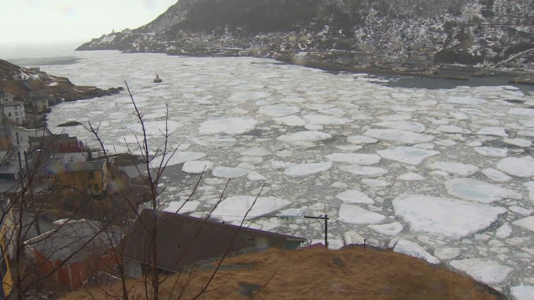
Rain and wind warnings were in effect for the Avalon Peninsula; the morning's heavy rains mixing with sloppy snow by the afternoon.
Snow mixed with ice pellets in St. John's by 5 p.m.
More than 35 millimetres of precipitation fell at St. John's airport between 3:30 p.m. Thursday and 3:30 p.m. Friday.
Strong winds with gusts of up to 100 km/h are expected to taper off by midnight.
Onshore winds from the northeast is also pushing sea ice towards coastal areas, filling coves and bays with ice.
There were no weather statements in effect for the Burin Peninsula Friday morning, however the region was expected to get about 5-10 mm of rain with snow mixing in late Friday afternoon.
Water had quickly accumulated on roads in certain areas. In Mount Pearl, the Ruth Avenue on-ramp to Pitts Memorial Drive was closed just after 11 a.m. due to water build up.
Newfoundland Power reported sporadic power outages due to the weather conditions, including on the southern shore of the Avalon Peninsula, as well as areas of central Newfoundland.
Customers were knocked off power in Gander, where about 40 centimetres of snow fell between Thursday morning and 5:30 p.m. Friday.
In St. John's, students were dismissed Friday morning from Waterford Valley High School, where a section of the roof was damaged, causing the school district to close the school as a safety precaution.
Blizzard warnings
Blizzard warnings remain in effect from Clarenville all the way up the northeast coast of the island to the Northern Peninsula. Strong winds of up to 110 km/h are expected in parts of those regions.
Clarenville, the Bonavista Peninsula and surrounding areas were getting rain Friday morning, however that transitioned to snow, which is expected to continue until Saturday morning.
Environment Canada says somewhere between 10 to 20 centimetres will fall between Friday afternoon and Saturday morning.
Areas further west and north — such as the central region, Green Bay-White Bay and the east coast of the Northern Peninsula — were blasted by snow on Friday, which is expected to continue as well.
La Scie recorded more than 50 cm of snow on Thursday and Friday, according to meteorologist Rodney Barney.
By the time the system moves out Saturday, another 10 to 20 cm are expected in the Green Bay-White Bay area, while another 2 to 4 cm should fall in the Northern Peninsula east region.
South coasts
Areas along the southern coast of Newfoundland, such as Connaigre and Burgeo-Ramea, were under wind warnings on Friday.
Gusts of up to 110 km/h are expected there, but should die down by about midnight.
Check out more sights and sounds from the spring storm below: