
St. John River could stay above flood stage for days, EMO warns
People living near the St. John River in and south of Fredericton are being warned that water levels could rise again in the coming days and remain above flood stage into next week
Around 795 people have been forced from their homes because of the flooding, according to the Red Cross. That number will increase as more people downriver from Fredericton make plans to leave, said Bill Lawlor, the provincial director of the Canadian Red Cross.
Floodwaters in the capital city dropped below eight metres on Thursday after reaching a record 8.35 metres on Tuesday. The river is expected to recede to 7.1 metres in Fredericton by Saturday but rise again to 7.4 metres Sunday, according to the province's five-day St. John River forecast.
The 8.35-metre mark surpassed last year's peak of 8.31 metres. Flood stage for the city is 6.5 metres.
Meanwhile, water levels in riverside communities south of Fredericton are forecast to continue rising before starting to recede over the weekend.
"This event is not over yet by any means," said Greg MacCallum, the director of New Brunswick's Emergency Measures Organization, during a news conference Thursday afternoon.
Environment Canada is forecasting rain for Friday and Saturday night, which is expected to bring higher water levels over the weekend.
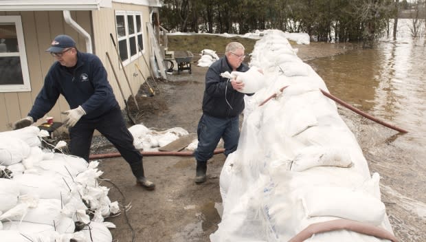
Officials stressed that it will be days before the lower basin falls below flood stage.
"We have seen some discernible differences in levels locally today," MacCallum said, referring to Fredericton. "But we're not at the recovery stage of this yet. Precipitation comes and goes, it ebbs and flows, and you will see the river do the same.
"This is going to be a slow burn. This is going to take some days."
Updated forecast
The fresh forecast is "a bit more promising," Jasmin Boisvert, water resources specialist with the Department of Environment and Local Government.
Boisvert said communities from Maugerville to Saint John should peak within the next 48 hours.
Saint John was expected to reach a historic high of 5.8 metres by Friday, but adjusted forecast has the water peaking at 5.6 metres before beginning to drop on Saturday. Flood stage is 4.2 metres.
Kevin Clifford, the Saint John EMO director and fire chief, said flooding has isolated 240 households from the mainland.
He said crews built up two roads to minimize the number of affected homes, and volunteers are performing wellness checks in affected areas.

Maugerville will fall just shy of seven metres Friday but sit at nearly a metre above flood stage into the next week. The water level in Grand Lake will recede slowly but remain more than a metre above the five-metre flood stage for at least the next five days.
In Lakeville Corner and Sheffield, the water is expected to stabilize at about 6.7 metres and in Jemseg at about 6.4 metres over the weekend. Their respective flood stages are 4.8 and 4.3 metres.
"There will be an increased amount of activity to the south because, as logic would dictate, the impacts are essentially moving into the southern basin of the river," MacCallum said. "This activity is, for the most part, still ongoing in the southern reaches of the river.
"As the water rises and things become more complicated, you'll see more road closures."
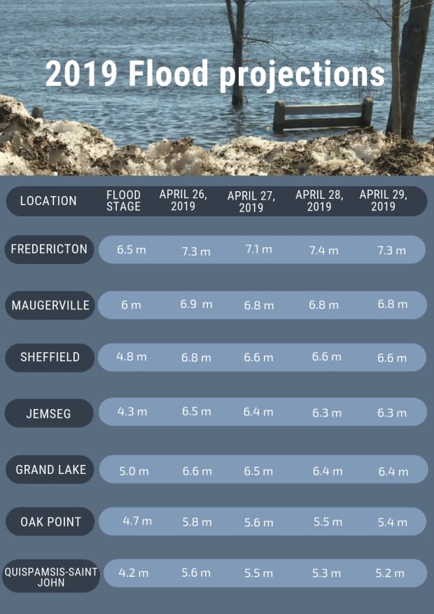
Saint Hilaire, near Edmundston, is the only community north of Fredericton still above flood stage, but that will change by Friday, said Boisvert.
EMO says prepare for worst
Ice floating on the water could cause more damage to people's homes and cottages and cost them more in repairs this year.
"Unlike last year, there's a bit more ice around this year," said MacCallum earlier on Thursday.
"If we get any significant winds, that will start washing up onshore and cause more problems."
CBC News explains the two types of floods along the St. John River
MacCallum said people who fled their home during last year's flood should consider doing so again this year.
"If they had to evacuate before, there's a strong likelihood they should again."
If people do decide to leave their homes, they should do so during the day, MacCallum said.
"It's infinitely simpler than trying to navigate at night or, in the worst case, having to be assisted by boating operations at night. That's risky business and we want to dissuade people if at all possible from waiting too long."

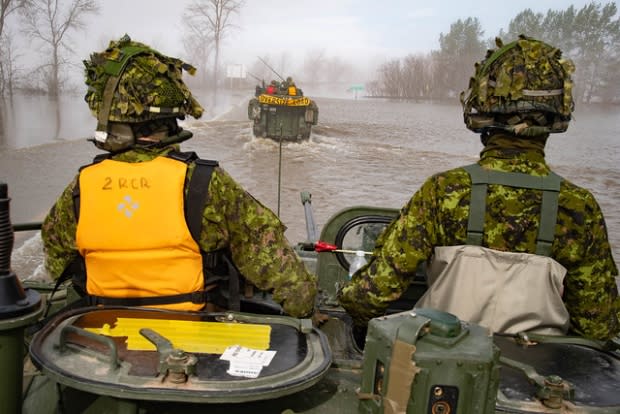
About another 100 members of the Armed Forces have joined the 250 troops on the ground assisting in flood-affected areas on Thursday.
Cooke Aquaculture, a New Brunswick fish farming company, has offered two boats to help with flood-relief efforts in Cambridge-Narrows, a village of about 650 people on Washademoak Lake, about 80 kilometres east of Fredericton.
The boats, which have a capacity of 12 people each, will be used to move emergency personnel, transport people out of flooded areas and move supplies into areas where water has cut off access.
Roads, some schools remain closed
The Trans-Canada Highway between Oromocto and River Glade, southwest of Moncton, closed Wednesday night because of flooding. The closure stretches from Exit 306 in Oromocto to Exit 423 in River Glade.
"Yesterday, [the water] was noticed to be starting to creep onto the roadbed itself, and in an abundance of caution, it was down to one lane for most of the day," MacCallum said. "But given the continual rise of water, the decision was taken last evening to close it, just to ensure it was safe."
Drivers must take a 90-kilometre detour, adding roughly an hour of travel time.
The highway could remain closed until early next week, according to Al Giberson, the general manager of MRDC, the company responsible for operating the highway between Moncton and Fredericton.
He said the company has to wait until the water recedes to assess the damage to the roads.
"The wind is causing a little bit of havoc down there this morning, which just poses another concern regarding damage to the side of the highway as well as water over the road," Giberson said.
More than 80 roads around the province are closed because of flooding, including a section of Route 10 near Chipman. That stretch of impassable road is important because Google Maps is directing drivers hoping to travel the closed Trans-Canada Highway to Route 10.
"We've got so many people travelling through to Halifax, Truro, Prince Edward Island, and I don't know why on Google Maps it didn't come up and say, 'You can't go through Highway 10,'" said Chipman fire Chief Barry Armstrong.
"It's all blocked on that end."

In Grand Bay-Westfield, crews are scrambling to keep rising water off the village's main road. They're using dump trucks to pile dirt and a grader to smooth it over to allow traffic to pass.
In Fredericton, the ramps onto the Westmorland Street Bridge remain closed, although the water is receding near them.
"We have to be very cautious about opening ramps or any roadway too soon. … We have to make sure that we can get an inspection on those ramps, and we're also expecting that the water level is going to come back up," said Mike Walker, the roadway operations manager for Fredericton.
The flooding has also caused schools to close this week. Cambridge Narrows, Chipman Elementary School and Chipman Forest Avenue School were closed because of the flooding Thursday. Schools in the Fredericton area that closed earlier this week were reopened.
This Maugerville farmer is not leaving his house. He explains why to the CBC's Heather Hiscox
