
Thunderstorm potential shifts on the Prairies, severe risk for some
Another stormy week is underway for parts of the Prairies after the first tornado of 2023 was confirmed for Canada in Saskatchewan over the weekend.
After a tornado warning was issued in southern Manitoba Tuesday, the risk for severe weather will shift out of the province for Wednesday. Multiple locations on the Prairies will need to be on the lookout for severe storm development Wednesday. That includes the risk for large hail and heavy rainfall.
Visit The Weather Network's wildfire hub to keep up with the latest on the active start to wildfire season across Western Canada.
A blocking high over Ontario is keeping the focus of the active weather to the Prairies for yet another week, but this time it be will much more widespread across all three provinces.
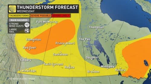
Wednesday
Areas: Alberta, Saskatchewan and southern Manitoba
Weather: The storm risk for Wednesday will continue across all three Prairie provinces as a low-pressure system tracks across the region. Severe thunderstorms are possible from central Alberta into northern Saskatchewan along a boundary, with large hail and strong winds the primary threat. There is even the chance for some rotating storms in the souther areas of Alberta and Saskatchewan. Temperatures will be even warmer in the south, climbing towards 30°C for some.
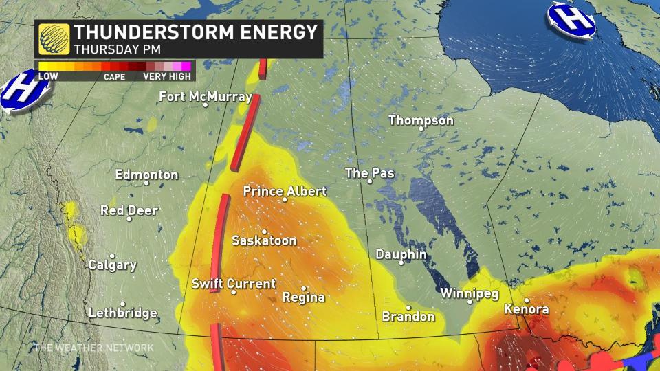
Thursday
Areas: Foothills of Alberta, much of Saskatchewan and extreme southern Manitoba
Weather: The thunderstorm threat will diminish slightly on Thursday for Alberta, with just the foothills looking at some isolated thunderstorms. The main focus will be along a trough in Saskatchewan and increased CAPE values or atmospheric instability to initiate thunderstorms through the afternoon and evening that will likely be quite widespread
Analysis
Disturbances embedded in a westerly flow will continue to trigger thunderstorms. The upper-level pattern evolves by Wednesday, as the Prairies are put in an unstable, southerly flow on the backside of a strong, high-pressure ridge across northwestern Ontario.
This means there will be a daily thunderstorm risk across the region, so check back often for thunderstorm forecast updates.
Prepare
Stay alert and monitor the forecast for updates. Have a plan and a place to head indoors if the weather changes.
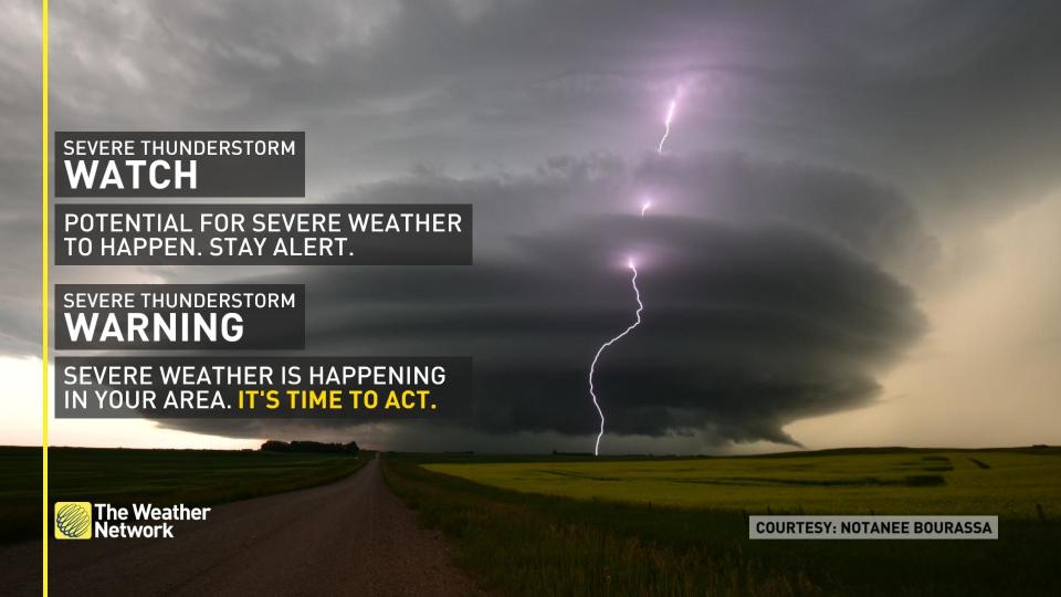
[Watches](https://www.theweathernetwork.com/en/news/science/explainers/how-severe-weather-is-communicated-in-canada) mean conditions are favourable for the development of severe thunderstorms.
[Warnings](https://www.theweathernetwork.com/en/news/science/explainers/how-severe-weather-is-communicated-in-canada) mean they are imminent or occurring in your area.
Thumbnail courtesy of Jason D, taken in Waldeck, Sask.
Stay tuned to The Weather Network for more forecast updates on the Prairies.

