
Portion of Yukon's Klondike Highway closed as wildfire burns nearby
Wildfires in Yukon have prompted the closure of several roads and highways around the territory including, as of Sunday night, the Klondike Highway between Pelly Crossing and Stewart Crossing.
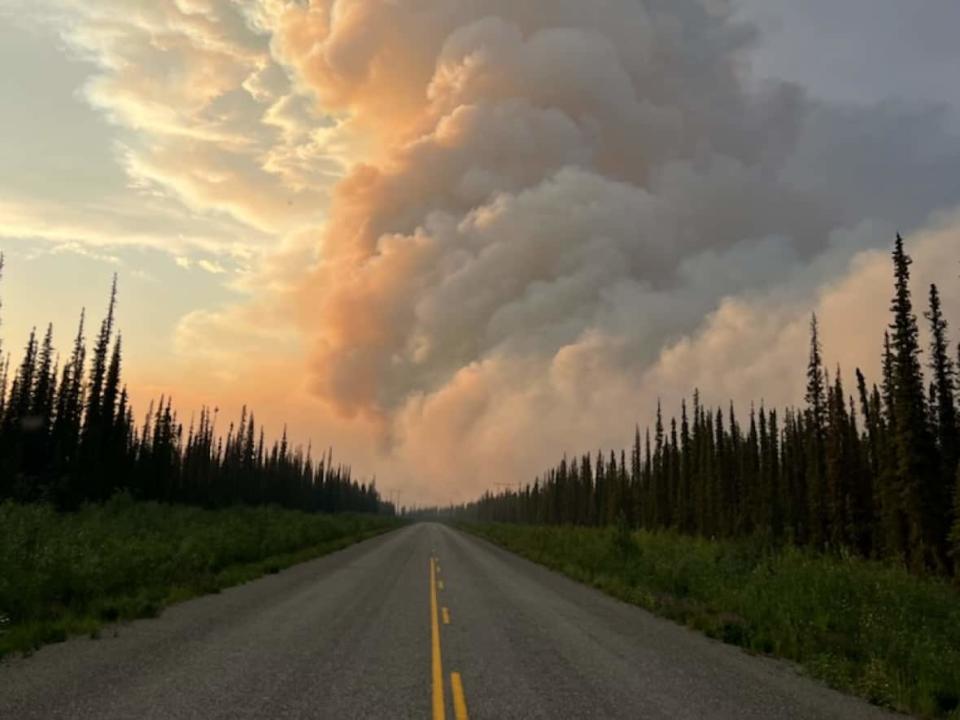
Haley Ritchie, with Yukon Wildland Fire Management, said the 1,500-hectare Crystal Creek fire was burning close to the highway, about 15 kilometres south of Stewart Crossing.
"The smoke is the hazard for travel right now. Last night, it was just too thick, too dangerous," she said, Monday morning.
"We're going to be reassessing this morning and it's possible the smoke will clear. If not, we're going to try and get an arrangement, maybe some pilot cars going, to try and help people make their way through that travel corridor."
A news release issued by emergency officials on Sunday evening states that there is no immediate threat to the community of Stewart Crossing, though the community remains on an evacuation alert.
Ritchie said Monday that it had been an "extraordinarily busy weekend" for wildland firefighters, with hot, sunny weather mixed with lightning storms causing around 20 new fires a day. As of Sunday, there were 82 active fires around the territory.
"We've got fires almost everywhere in the territory," Ritchie said.
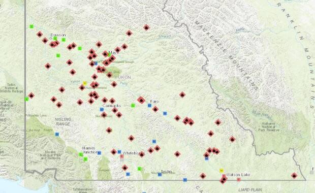
The Silver Trail area — around Stewart Crossing, Elsa, Mayo and Keno — has been a real hotspot in recent days and Ritchie says residents should be aware that the weather is not expected to change much in the coming days. On Monday, Environment Canada issued a heat warning for Mayo along with many other Yukon communities.
A territory-wide fire ban was issued on Thursday. That means cooking and warming fires are only permitted in provided fire pits at road-accessible government and commercial campgrounds. No other open fires are allowed anywhere.
Other closures
Along with the Klondike Highway near Stewart Crossing, the Robert Campbell Highway between Watson Lake and Ross River remains closed. The nearby Frances Lake wildfire was over 600 hectares in size as of Sunday.
"It's just too close to the highway. Same thing, just too hazardous to allow travel through there right now," Ritchie said.
The Nahanni Road, which runs north from the Robert Campbell highway to the N.W.T. border, is also closed.
She said officials are also watching some other big fires, including one about 15 kilometres from Beaver Creek. She said smoke is visible from that fire but the community is not under threat right now.
Some B.C. firefighters were in Yukon over the weekend to help local crews. Ritchie says more relief was expected from B.C. this week.
Meantime, the Alaska Highway, a major artery for the Yukon's supply chain, was also still closed Monday morning after a major washout on Friday.
Updated highway conditions for Yukon can be found at 511yukon.
