
Tornado touched down south of Regina Saturday night, Environment Canada confirms
It was a normal Saturday for Kathleen Fellinger and her family, who were spending the evening in the sunshine having a barbecue. Then the weather turned.
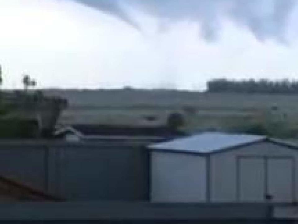
"It was just raining very, very little. But there was lots of lightning and I looked off into the distance... [and] we saw what looked like a massive cloud and it was just swirling," said Fellinger, who lives near the McKell Wascana Conservation Park in southeast Regina.
A funnel cloud had formed in the sky, but it wasn't connecting to the swirling cloud on the ground, she said.
"If that connects, it's going to be really powerful," Fellinger recalled thinking at the time.
People in the Regina area with a cellphone received an alert around 9 p.m. Saturday, informing them that a tornado may have touched down about 10 kilometres south of the city and was travelling northeast. The alert provided potential safety strategies, such as seeking refuge in a basement.
Shortly before 10:30 a.m. Sunday, Environment and Climate Change Canada (ECCC) confirmed on its website that the tornado had occurred. It has since learned the tornado touched down six kilometres southeast of the city.
"This feels definitely like the most significant stormy weather we've had in this part of the province [so far this season]," ECCC meteorologist Brian Luzny told CBC News Sunday.
It is somewhat unusual for such weather to occur in May, Luzny said, but these types of storms can happen from this point on through the rest of the summer.
ECCC said there have been no reports of damage from the tornado. The tornado has been given a preliminary rating of EF0, the weakest tornado possible on the Enhanced Fujita scale.
Thunderstorm warnings had been in place for much of southern Saskatchewan Saturday evening, but that was escalated to a tornado warning for parts of southeastern Saskatchewan around 9 p.m., when members of the public reported a tornado to ECCC.
Some streets flooded and buildings leaked in Regina Saturday night due to pelting rain and hail. An ECCC weather station near the airport reported 17.1 mm of precipitation between 9 p.m. and 10 p.m.
The sudden downpour led to flash flooding throughout parts of the city, including the intersection of Winnipeg Street and College Avenue, in the Arnheim Place neighbourhood.
Maximus Warby, his brother Nick and their friend helped direct traffic through a large pool of rainwater at the intersection for at least an hour.
The intersection generally doesn't drain well during heavy rain, they said. But last night, at its highest, the water was about knee to thigh-height.
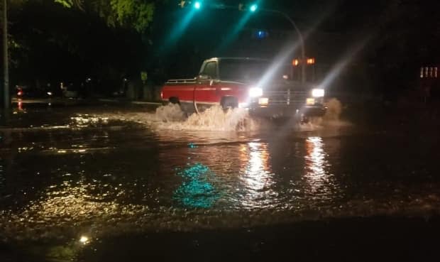
"This is the worst we've ever seen [this intersection] so far," Nick Warby said, as they all live in the area.
"We have lost two or three cars so far; they've just stalled."
There's potential for severe storms in southeast Saskatchewan again Sunday, Luzny said, but they would be less severe than Saturday.
There will likely be some thunderstorms that could produce hail and strong wind gusts, he said.
