
'Extremely dangerous' snow squall event unfolding in southern Ontario

Prepare for rounds of heavy snow across parts of southern Ontario through the weekend as the pattern grows more favourable for persistent snow squalls to develop off the Great Lakes.
Some parts of the province could see thigh-high snow by Sunday, a walloping that will significantly disrupt travel through the affected areas.
DON'T MISS: Intense squalls could bury this major city under 100+ cm of snow

We’re watching four separate targets for bands of heavy lake-effect snow to develop in the coming days.
Communities east and northeast of Lake Huron, Georgian Bay, Lake Erie, and Lake Ontario will have to be on the lookout for rapidly changing conditions heading into the weekend.
Snow is falling at an incredible rate right now. Be safe out there. #hwy402 #Strathroy @weathernetwork @WeatherNation #ONStorm pic.twitter.com/HQE8WetiyT
Snow is falling at an incredible rate right now. Be safe out there. Cara Bissonnette🇨🇦 on Twitter: "Snow is falling at an incredible rate right now. Be safe out there. #hwy402 #Strathroy @weathernetwork @WeatherNation #ONStorm pic.twitter.com/HQE8WetiyT / Twitter" Cara Bissonnette🇨🇦 on Twitter: "Snow is falling at an incredible rate right now. Be safe out there. #hwy402 #Strathroy @weathernetwork @WeatherNation #ONStorm pic.twitter.com/HQE8WetiyT / Twitter" Cara Bissonnette🇨🇦 on Twitter: "Snow is falling at an incredible rate right now. Be safe out there. #hwy402 #Strathroy @weathernetwork @WeatherNation #ONStorm pic.twitter.com/HQE8WetiyT / Twitter" Cara Bissonnette🇨🇦 on Twitter: "Snow is falling at an incredible rate right now. Be safe out there. #hwy402 #Strathroy @weathernetwork @WeatherNation #ONStorm pic.twitter.com/HQE8WetiyT / Twitter" Cara Bissonnette🇨🇦 on Twitter: "Snow is falling at an incredible rate right now. Be safe out there. #hwy402 #Strathroy @weathernetwork @WeatherNation #ONStorm pic.twitter.com/HQE8WetiyT / Twitter" Cara Bissonnette🇨🇦 on Twitter: "Snow is falling at an incredible rate right now. Be safe out there. #hwy402 #Strathroy @weathernetwork @WeatherNation #ONStorm pic.twitter.com/HQE8WetiyT / Twitter"
— Cara Bissonnette🇨🇦 (@CaraLBiss) Cara Bissonnette🇨🇦 on Twitter: "Snow is falling at an incredible rate right now. Be safe out there. #hwy402 #Strathroy @weathernetwork @WeatherNation #ONStorm pic.twitter.com/HQE8WetiyT / Twitter"
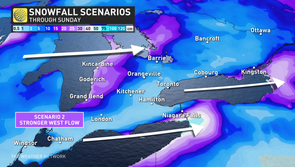
It’s a classic setup for significant lake-effect snow — cold westerly and southwesterly winds blowing over the warmer lakes will lead to multiple bands of snow rolling onto the lakeshores.
The orientation of the winds will favour thick, persistent bands of snow over narrower, gentler bands, which will dump mounds of snow on some communities while others nearby will see more manageable totals.
The direction of the winds will play a key role in both how much snow falls and where the heaviest snows will occur.
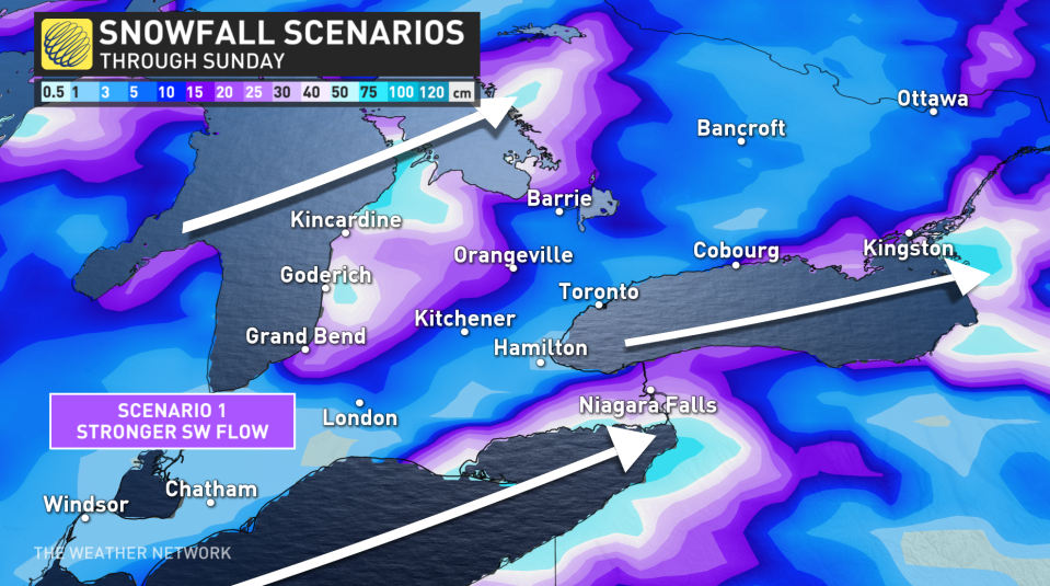
If the winds take on a more southwesterly orientation, cold air will spend more time blowing over the warmer waters, allowing for beefier bands of snow to develop and wash over coastal communities.
A more westerly component, though, will cut down the amount of time those chilly winds spend over water, cutting down the accumulation potential for the duration of this event.
PHOTOS: Quick snap into winter with first major snow in the GTA
Travel will become treacherous or downright impossible during the heaviest bands of snow, where visibility may approach zero at times and roads will quickly become impassable due to rapid snow accumulation.
"Road closures are possible," says Environment and Climate Change Canada (ECCC) in a snow squall watch issued late Wednesday. "Consider postponing non-essential travel until conditions improve. If you must travel, keep others informed of your schedule and destination and carry an emergency kit and mobile phone."
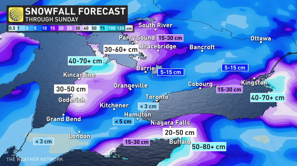
Danger zones: Most impactful snowfall totals
The most populated areas at risk for impactful snowfall totals will be the northeastern shores of Lake Erie and Lake Ontario. Very heavy snow is possible across the Niagara Peninsula, with the potential for a sharp gradient between intense snow and a sightly winter scene.
Farther north, the areas along Lake Ontario at greatest risk for disruptive snow will fall along the 401 in and east of Cobourg.
Due to the nature of lake-effect snow, storm totals will vary widely over short distances and between one community and another. Widespread totals of 25+ cm are possible throughout the region, with localized amounts of 50+ cm possible under the heaviest and most stubborn bands that develop.
Stay tuned to The Weather Network as we monitor this developing lake-effect snow event.
