
Tricky travel likely as another wintry storm rolls into Ontario
Get ready for another high-impact winter storm to begin the final week of February. With the beginning of spring a couple of weeks away, Ontario will continue to see wintry weather across the province.
This forecast will sound like a bit of a repeat after the disruptive storm that swept across the province last week. Much like that last storm, we’ll see widespread snow, ice, and rain arrive Monday evening and last into Tuesday for some areas.
DON’T MISS: Ice falls in Hollywood as wild setup fans Calif. blizzards, historic heat
However, a smaller area will face the threat of impactful ice this time around and total snowfall accumulations will be lower than the last Colorado low.
Special weather statements are in effect for much of southern Ontario ahead of this messy system.
A blustery Colorado low will push into the Great Lakes on Monday, with precipitation spilling over southern Ontario late afternoon. The morning commute is expected to be fine for almost everyone, but the Monday evening commute will be an absolute mess for some as untreated surfaces may become icy and slippery.

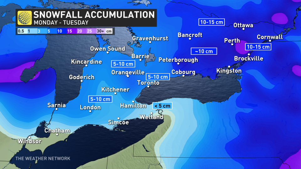
Snow will fall on the northern side of the system, with a cumbersome mix of snow, ice pellets, freezing rain, and the focus of rain along the shores of Lake Erie.
As warmer air moves in, we'll see a transition to ice pellets and patchy freezing rain southwest of the Greater Toronto Area, but not before the aforementioned region records between 5-10 cm of snowfall.
WATCH: Why this Ontario storm won't be like the last
RELATED: 'Common sense' driving tips to help steer through Canada's winter
Cottage country and eastern Ontario stand to witness the heaviest snowfall, with most areas reaching close to 10 cm of snowfall, with around 15 cm falling across the Ottawa area.
Gusty winds up to 70 km/h will result in reduced visibility on the roadways around the GTA Monday evening, so motorists should expect difficult winter-driving conditions. Local power outages are also possible.
“Winter weather travel advisories may be required as the event draws nearer,” Environment and Climate Change Canada (ECCC) said in its special weather statement.
The winds will then transition to blow toward the southwest on Tuesday, bringing a swath of warmer air to the area. Along the Golden Horseshoe, the snow will transition into rain on the back half of the system Tuesday morning.
The greatest chance for light ice accretion from freezing rain will fall along parts of the Niagara Escarpment, stretching from Kincardine to Chatham and east toward the Hamilton area.

Although conditions will improve across the southwest on Tuesday, heavy snowfall will continue affecting Ottawa and eastern Ontario.
Continue checking in with The Weather Network for more details on where these precipitation divides will set up and how this storm will affect Ontario to begin the work week.

