
There are two tropical waves in the Atlantic. Are they affecting South Florida’s weather?
Forecasters are monitoring two tropical waves Thursday night and one of them could turn into a tropical depression as it moves through the Caribbean Sea this weekend.
The other wave, east of the Lesser Antilles, could also see some development in the next five days though forecasters say its chances are much lower.
A broad area of low pressure is also expected to develop over the western Caribbean Sea or the extreme southern Gulf of Mexico by Thursday night or Friday, according to the hurricane center. A “bubble of upper-level winds” could also develop over the western Caribbean later in the week, according to Local 10 Hurricane Specialist Bryan Norcross.
Both the broad area of low pressure and the upper-level winds would develop near the first tropical wave, Norcross said.
And while it’s still unclear how they would all end up working together, “broadly speaking, the forecast weather pattern is one that can produce bands of very heavy rain across South Florida,” Norcross said. “On the current schedule, this would come together about Friday, plus or minus, and last into most or all of the weekend. “
Are the tropical waves affecting South Florida’s rain chances?
South Florida was already expecting a rainy weekend because of a front that has stalled across the region, according to the National Weather Service.
What the tropics are doing is bringing more moisture to the area, which could potentially lead to higher rain chances through the weekend, the National Weather Service said.
Miami-Dade, Broward and Palm Beach are under a flood watch until Sunday evening, with 4 to 6 inches of rainfall possible with some isolated areas possibly seeing even higher amounts, according to the NWS’s hazardous weather outlook..
South Florida has a 50% chance of rain Friday. Its rain chances vary through the weekend, ranging from 40% to 80%, according to the National Weather Service.
“The flooding potential across the region may increase into this weekend, especially for the eastern metro and coastal areas due to the combination of heavy rainfall and high astronomical tides,” according to the weather service hazardous weather outlook. “Thereis uncertainty in how widespread and impactful this flooding may be,so keep up with forecast changes.”
Oct 1 - Heavy rain and flooding possible into this weekend, especially along the Atlantic coast where a Flood Watch is in effect. Remember if you encounter flooded roadways turn around, don't drown. #flwx pic.twitter.com/8YVQn3eJ22
— NWS Miami (@NWSMiami) October 1, 2020
Where are the tropical waves right now and where are they going?
Wave 1 was producing showers and thunderstorms over the west-central Caribbean Sea just south of Cuba Thursday and is forecast to continue moving westward over the next couple of days, according to the National Hurricane Center’s 8 a.m. advisory.
Forecasters say the environmental conditions would become conducive for a tropical depression or tropical storm to form on Friday or Saturday.
“Regardless of development, this system is expected to produce locally heavy rains, with possible flash flooding, over portions of southeastern Mexico, Central America, and western Cuba during the next several days, and interests in those areas should monitor the progress of this disturbance,” forecasters said.
The tropical wave has a 70% of forming in the next 48 hours and a 80% chance of forming through the next five days, according to the hurricane center.
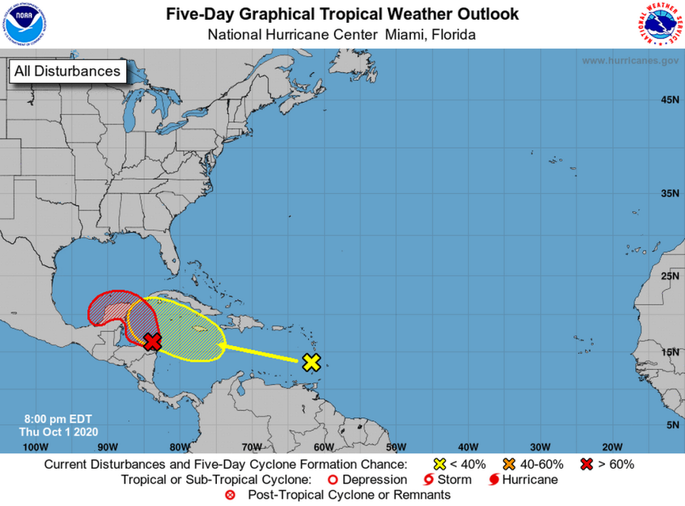
Wave 2 was producing widespread cloudiness and disorganized showers across the Lesser Antilles Thursday night.
“This wave is forecast to move westward at 15 to 20 mph during the next several days, and environmental conditions could become a little more conducive for development when the system is over the central or western Caribbean Sea early next week,” forecasters said.
It has a 0% chance of forming in the next 48 hours and a 30% chance of forming through the next five days.
