
U of O project using Google Street View to spot gentrification
A group of researchers at the University of Ottawa is using Google Street View to spot instances of gentrification in the city's neighbourhoods.
Professor Michael Sawada and two students created an artificial intelligence program that scans 360-degree panoramas from 2007 to 2016 for signs of social and economic change.
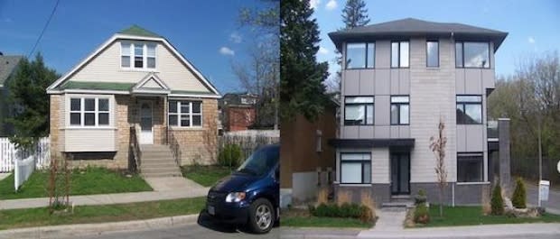
The program looks for patterns of improvements on individual properties, such as new fences, landscaping, siding or significant renovations.
"People in higher socio-economic status like to express their wealth through material things," Sawada told CBC Radio's Ottawa Morning on Thursday, using vehicles as another example.
95 per cent accuracy
Once the program was trained, it had 95 per cent accuracy in detecting these indicators of gentrification, a process of renovating and improving properties so that they appeal to what Oxford defines as "middle-class taste" — while also potentially forcing lower-income people and smaller businesses out of those neighbourhoods due to rising rent.
"Hintonburg has been talked about a lot in the last decade. So has Westboro. These areas are gentrifying and continue to be gentrifying," Sawada said..
"There's gentrification probably happening in other places we don't generally talk about. It doesn't mean that people living there don't know about it — they notice contractor trucks lined up along their street."
Previous studies have used census data to try and identify and analyze gentrification, but Sawada said this project is the first to use pictures.
The team was able to detect close to 3,500 indications of gentrification in approximately 3,000 unique places in Ottawa's urban core.
A pair of examples
"We wanted to look at gentrification in detail and also [find] where else it might be happening," he said. "It's humanly not possible. Nobody wants to do all that work, so we farmed it out to AI."
He used the Crestview-Meadowlands neighbourhood near Algonquin College and Island Park Drive south of Wellington Street W. as examples the program has flagged where something may be happening.
The group from U of O's geography, environment and geomatics department hopes the research can be used to help city planning and address inequality.
Nevertheless, Sawada acknowledges developers may also use it to try and get into an up-and-coming area.
