
After warm start to fall, temperatures to cool down for a few days throughout Sask.

Fall may be underway in Saskatchewan, but the summer heat has stuck around.
September temperature statistics from Environment and Climate Change Canada (ECCC) show most weather stations in the province reported an above-average September.
Maple Creek, for instance, was more than five degrees above its monthly mean temperature. The place that deviated least was Prince Albert, which was still 2.3 degrees above the mean.
Many of the stations recorded temperatures within the top 10 for warmest Septembers on record. La Ronge had its second-warmest in 59 years of record-keeping. In fact, the town only had one day of below-average temperature in the entire month.

Swift Current, meanwhile, had its fourth-warmest September in 137 years. Regina had its eight-warmest in 129 years.
Regina also tied a record for most days 30 C or warmer in September. The city had six, matching Septembers in 2011 and 1938.
Around 70 daily temperature records were broken throughout September — from Collins Bay in the north to Eastend in the south.
It was also a dry start to fall, with all stations failing to get more than 60 per cent of normal monthly precipitation. Almost all stations were within the top 20 for driest Septembers.
Swift Current, which only recorded 13 per cent of its monthly moisture, had its 11th-driest September in 137 years.
Severe weather subsides
As was expected, severe summer weather in Saskatchewan came to an end in September.
It was an active summer filled with large hail, heavy rain and strong wind that did damage to many communities.
The province's official tornado count for the year, according to ECCC and the Northern Tornadoes Project, sits at 25 as of Tuesday. That's the most tornadoes in one year in the province since 2012, when more than 30 were reported.
The count includes four EF-2 tornadoes — the most in well over a decade. It also includes a waterspout that touched down on Lake Athabasca — an area that very rarely sees tornadoes.
Terri Lang, a meteorologist with Environment and Climate Change Canada, said a wet spring set the stage for a stormy summer.
"The moisture coming in the spring helps crops grow. When they grow, they give off a tremendous amount of moisture, and that moisture is used for storms," Lang said. "And when the storms can grow, we have a better probability of tornadoes."
Twenty-two of the 25 tornadoes occurred in June and July.
David Sills, executive director for the Northern Tornadoes Project, says the number of tornadoes was high, but not much higher than a typical year.
"Mid-June through mid-August is the the big period where tornadoes occur and we definitely saw that this year," Sills said.
"Last year [2021] was the real oddball, because in that period of mid-June to mid-August there were no tornadoes on the Prairies."
Lang said that while tornadoes were up, lightning strikes were below normal.
She said there have been about 600,000 strikes so far this year, compared to the long-term average of 700,000 lightning strikes.
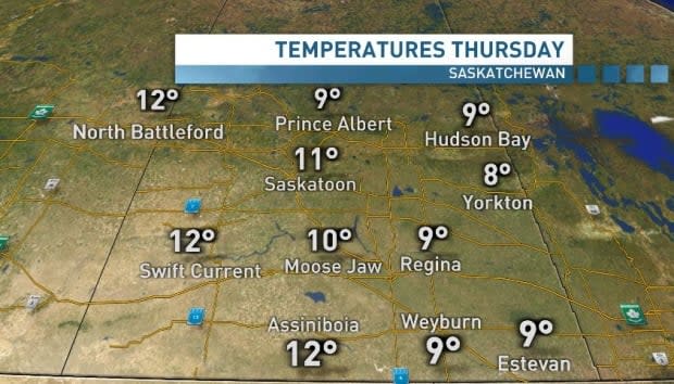
Temperature free fall in store
Just like the leaves on the trees, our temperatures will soon fall fast, but the dip won't last long.
An unusually strong area of high pressure is moving in from the Northwest Territories. This will make it difficult for daytime highs to reach double digits on Wednesday and Thursday.
The maximum barometric pressure is expected to top out around 1,040 millibars (mb). The average barometric pressure in the province usually hovers somewhere close to 1,000 mb. Even a 10 mb spread from there can mean the difference between a high pressure or low pressure system.
There is potential for record-breaking barometric pressure readings. We'll likely know by the end of the week.
Temperatures will quickly rebound as high pressure moves out. We'll be back into the mid to upper teens by the weekend, with mostly sunny skies.
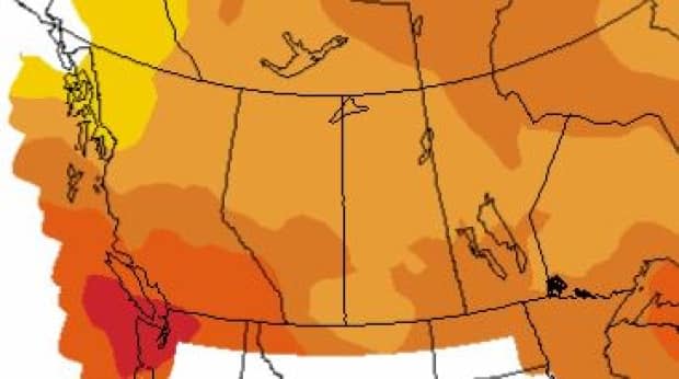
The warmer weather may be here to stay for a while. According to ECCC's three-month probabilistic outlook, published last week, much of the province has a 50 to 70 per cent chance of seeing above-average temperatures through October, November and December.
