
Why this company built a search engine for satellite imagery

From the launch pad of India's Satish Dhawan Space Centre, 88 tiny satellites hitched a Valentine's Day ride into space.
The satellites joined an existing network of orbiting cameras, operated by a company called Planet, that are working in tandem towards a singular goal: to have freshly updated images of every place on Earth each day.
Planet and its competitors say the images captured by their satellite constellations are already creating new opportunities for businesses, governments, and academics who have never had access to data this frequent or fresh. But the looming challenge is how to make sense of it all, which is where players like Descartes Labs come in.
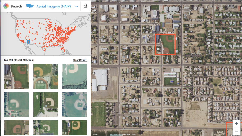
On Tuesday, Los Alamos, N.M.-based Descartes Labs unveiled its take on finding signals in the noise, with software called GeoVisual Search. Point it at a baseball diamond, and it can find other baseball diamonds in satellite imagery from across the U.S. The same goes for wind turbines, golf courses or the patchwork of circular crops you can see from high up in the sky. Give it a recognizable landmark, object or geographic feature, and GeoVisual Search will try to find others like it around the world.
The tool, inspired by an open source project called Terrapattern, may just be a public-facing demo, but it's a glimpse at where the satellite industry is heading next.
"We have to get prepared for this onslaught of data otherwise we're going to have a bunch of pixels that won't be analyzed for years," said Mark Johnson, CEO and co-founder of Descartes Labs, in an interview. That means giving miners, logistics companies, non-governmental organizations, environmental agencies and others the ability to comb through lots and lots of imagery quickly, and do it themselves.
From suburbs to solar farms
Traditionally, access to high-resolution and up-to-date satellite imagery has been limited to those who can afford to pay. And not many people have the skills needed to work with the data that comes back. But by making satellite imagery more accessible, the hope is that businesses, governments, academics — even your average internet user — can find insights that once required deep pockets and a PhD.
To make it happen, Descartes Labs has trained a neural network on three sources of satellite imagery of varying resolutions. The network extracts features from small areas of imagery, such as edges, shapes and colours. When a user clicks on a landmark, such as a tennis court or airport runway, the GeoVisual Search software examines the features in the selected area on the map and looks for other areas with similar features.
"We've never taught the computer what a suburb looks like specifically," says Johnson, as he clicks on a random cluster of cul-de-sacs in Iowa, which the software says look similar to the suburbs found in Edmonton. "It's really doing a search over the entire globe trying to figure out what is visually similar."
GeoVisual Search is intended as a glimpse at what Descartes Labs can do for clients behind the scenes. The idea is to offer customers a service that can reliably identify whatever assets they want — be it ships, shipping containers, or solar farms — and track changes to those assets over time, worldwide, as new daily imagery comes in.
"A logical next step after this is counting things precisely," says Johnson, name dropping things like oil rigs, wind turbines, manufacturing plants and dams. The company aims to make its service available later this year.
Finding signals in the noise
Descartes Labs isn't the only company operating in this space.
Orbital Insight has used machine learning to count cars in mall parking lots as a proxy for retail traffic, and measured the height of buildings under construction in China as a gauge for economic health. And last month, Planet acquired the company Terra Bella from Google. It builds and launches satellites, and also does image analysis.
Similarly, Descartes Labs has used its imagery to generate forecasts of corn production that its says are more accurate than the U.S. Department of Agriculture's own. But the next step is building a system that can do analysis for any client or industry, and do it on a country-wide or global scale, which is one of things Johnson believes sets Descartes Labs apart.
"The dark side of a lot of data is finding salient things in large data sets becomes harder and harder," says Johnson. Both the challenge and opportunity for Descartes Labs and its competitors will be accurately separating the stuff that's important from the stuff that's not.
