
How Saskatchewan's roller-coaster winter compared to other years

This winter was supposed to be closer to a typical Saskatchewan winter — key phrase is "supposed to."
Forecasts were calling for normal precipitation amounts and slightly cooler than normal temperatures, following the 2015-16 non-winter.
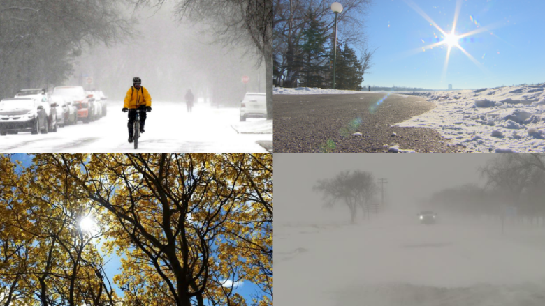
But by October, it looked like we were in for a rough one, with snow right out of the gate. By Oct. 6, up to 40 centimetres of snow fell in Saskatchewan's southwest, with close to 20 centimetres in Saskatoon. The snow toppled trees and made a mess of the roads throughout the province.
Though the snow did melt away, the precipitation kept on coming. By the end of the month, Regina and Saskatoon saw over twice their normal precipitation amounts, making it the third wettest October on record in the Queen City. Temperatures for October also came in a couple of degrees below seasonal.
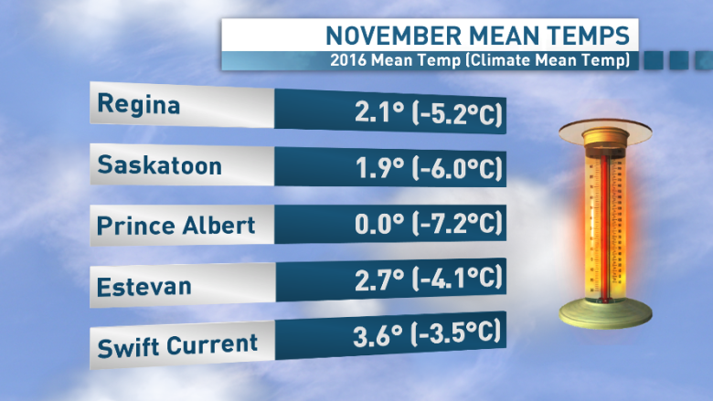
As we turned the calendar to November, the weather took a sharp U-turn. Temperatures soared into the 20s early in the month, and in Regina, 24 of the 30 days jumped above the freezing mark. The average daily temperatures for the entire month averaged around 2 C in Regina, making it the hottest November ever recorded.
Saskatoon saw its second hottest November on record, with an average temperatures just below 2 C.
Just when we thought we could get used to another balmy winter, Mother Nature threw a curveball. Temperatures plummeted towards –30 C by mid-December, with extreme wind chills into the –40-degree range in most areas.
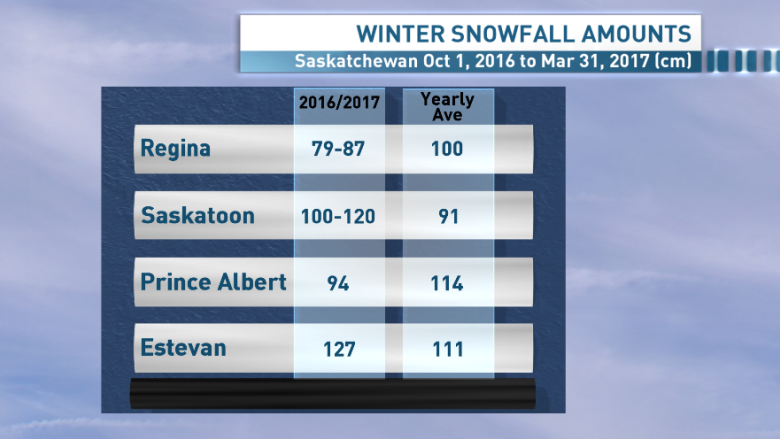
The snow also would not let up, with 52 centimetres falling in Estevan, Sask., making it the snowiest December in 100 years.
Northeast Saskatchewan saw the brunt of the snow, with around 215 centimetres falling in Collins Bay.
The cold stretched into the new year, with four days below –30 C in the first half of the month in Regina.
But the heat made a comeback for the end of January. Regina and Saskatoon each saw eight days above the freezing mark towards the end of the month, when on average those cities would see just over four days.
February saw some chilly days early on but the warm weather continued to dominate through most of the month, with temperatures averaging three degrees above normal.
March came in like a lamb, and it really did feel like winter was over — that is, until we got to the blizzard on March 6. A strong Colorado Low swept through Saskatchewan, bringing heavy snow to the southeast and damaging winds.
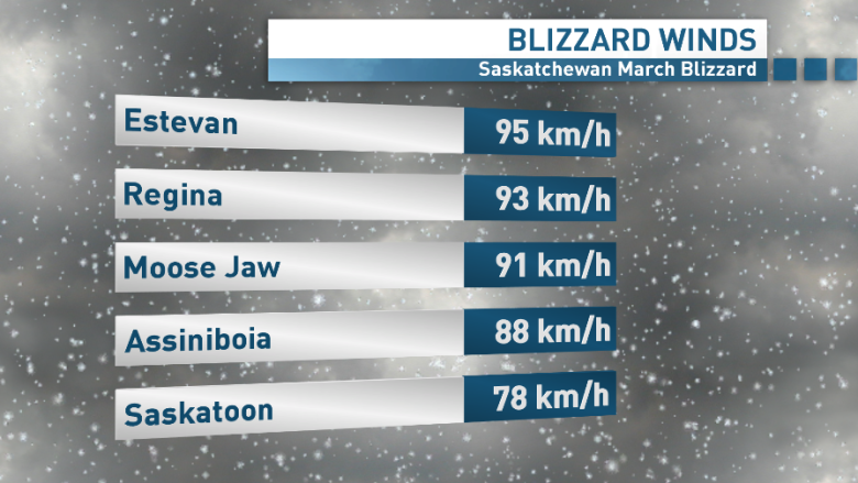
By March 7, wind gusts peaked close to 100 km/h in the southeast, grounding flights and closing highways. Widespread whiteout conditions swept through with all of that fresh snow.
In total, Estevan went 32 hours with visibility under 400 metres before the blizzard let up on March 8.
In the end, this winter was considered warmer than climate normals for most areas and a little more sporadic in terms of snowfall. But this winter's averages were the product of the extreme changes in our day-to-day and month-to-month weather.
What will the rest of the spring hold for Saskatchewan? So far, seasonal forecasts are pointing towards above normal temperatures and close to normal levels of precipitation from now until June.
But if this past winter is any indication, anything can happen when it comes to our prairie weather.
