
There's a map for that: ski club releases guide to Iqaluit-area trails

Iqaluit's Aniirajak ski club has published a trail map, which is now available at the Unikkaarvik Visitor Centre.
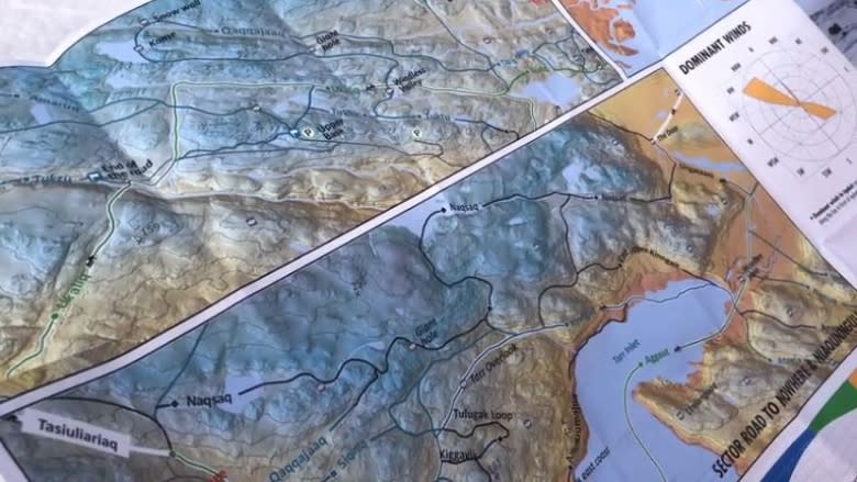
The map is the result of two years of work by the club's board, its president François Fortin, and geologist Tommy Tremblay.
Fortin skied all the routes on the map—and many more—during his last five years as an Iqaluit resident.
"Here the land is wide, and there's no trees, so we can basically ski and go anywhere, but we found that people don't know where to go, they're afraid to explore a little bit," Fortin said.
The trails were chosen for their nice views and the fact they regularly have enough snow, Fortin said.
The map includes lookout spots and safety tips, including hours of daylight, tide range and the area's dominant winds.
It's meant to help both tourists and residents plan outings on the land. It suggests good starting locations and gives the trails' approximate skill level.
Geo-referenced map
In a few weeks, the map will also be downloadable onto a smartphone, using a free app that supports PDF maps. Once the map is downloaded, skiers can track their location on the map using the GPS in their phone, which does not require cell service.
The download link will be on the club's Facebook page and soon-to-be-live website. In coming ski seasons, the club is planning to print more durable maps and maps in French and Inuktitut.
The current version was consulted on by the City of Iqaluit, the territorial government, the Iqaluit Hunters and Trappers Association and the Inuit Heritage Trust for the proper Inuktitut names for the trails.
The ski club also runs Toonik Tyme races, school programs, training sessions for beginner skiers and a ski rental program that Fortin says will be available out of the visitors' centre before then end of this year's ski season.
