
Blizzard, winter storm warnings issued in Ontario ahead of holiday storm
A rare winter storm is fast approaching and residents across Ontario are being urged to consider altering travel plans through the holiday weekend as road conditions are likely to become dangerous and at times, life threatening. Extensive utility outages are possible as well, alongside the chance of road and store closures, and flight cancellations or delays.
This mammoth winter storm is set to move in at the worst time for driving -- putting millions at risk of being caught on the roads during the storm through the Christmas weekend.
Heavy snow, potentially damaging winds, a flash freeze, rain and even the risk of ice pellets are all risks with this multi-day storm.
RELATED: Holiday havoc: Vast, 3,000-km-sized storm puts travel plans in peril
Widespread winter storm watches and and blizzard warnings have been issued, along with rainfall warnings and special weather statements also in place.
Thursday: System arrives in the form of a wintry mix of snow and rain
The first part of Thursday is the best opportunity to get any travel done and avoid major precipitation and impacts. The system will arrive in southern Ontario Thursday with a fairly light wintry mix of snow and rain. Precipitation will be fairly light and will continue to spread east and fill in through the second half of the day.
Across northern and northeastern Ontario, snow will be spreading in through much of the day. As the centre of the low-pressure system approaches the Great Lakes, expect precipitation rates to increase through the evening and overnight.
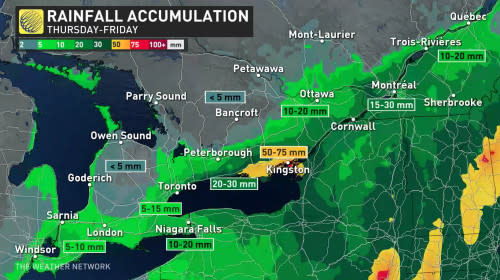
During the transition from snow to rain Thursday overnight into Friday morning, there is a risk of freezing rain and ice pellets for many areas.
Friday: Threat for a flash freeze
Temperatures will start in the low single digits on Friday, before cold air begins to get wrapped in behind the low, then temperatures take a considerable dive.
Wet surfaces from the rain in southwestern Ontario could ice over and become quite slick as rain transitions to snow and a flash freeze is possible.
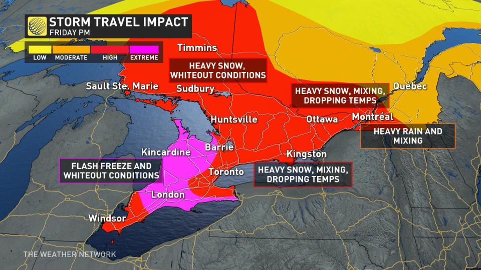
For the Greater Toronto Area (GTA) and southern Ontario, rain will transition to snow as temperatures fall through late morning, lunchtime and beyond.
Snow accumulations will not be major for the GTA, however, with so many people traveling, it is extra important to be aware of what is happening all around us with the extremely dangerous travel conditions.
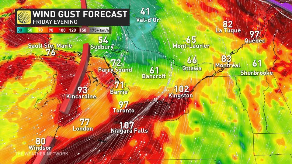
Strong wind gusts will also be a risk on Friday as the low-level jet stream parks itself over southern Ontario. Wind gusts will intensify throughout the day with lakeshore gusts along Lake Huron, Erie and Ontario potentially exceeding 90 km/h. Widespread wind gusts of 70-80+ km/h can be expected across the rest of southern Ontario.
The impact of these winds include possible power outages, blizzard conditions and widespread whiteouts within the snow falling across the region.
Large waves can be expected for communities along the lakeshore and ice shoves or ice buildup along the shoreline are possible with powerful southwest winds.
WATCH: What is a flash freeze, and why is it so dangerous?
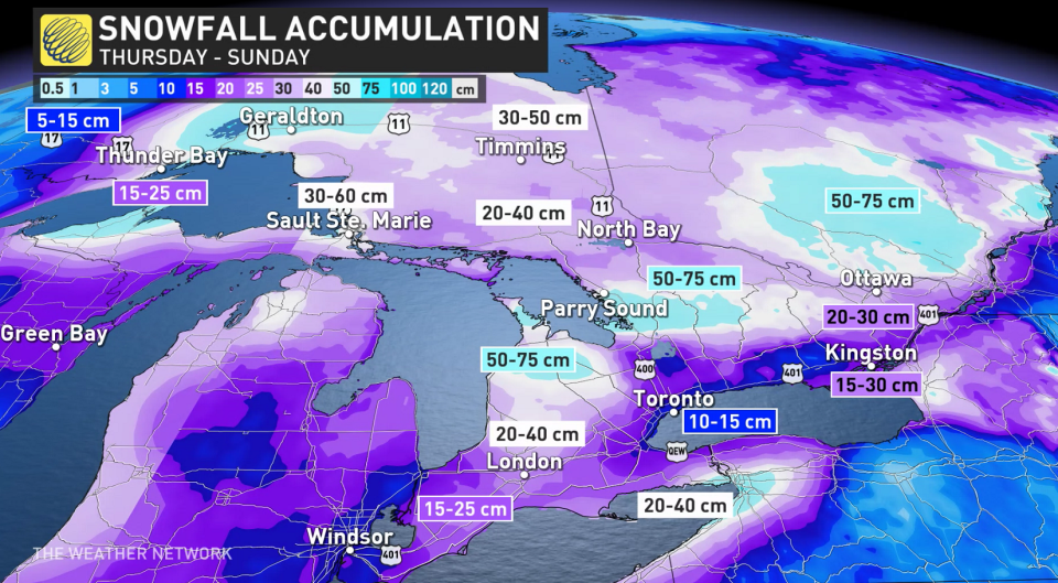
Saturday (Christmas Eve): Powerful winds continue to howl, intense lake-enhanced snow squalls
Although widespread snowfall rates are expected to decrease Saturday morning, many won’t notice due to the powerful winds, which will continue to howl across the region.
There will be intense lake-enhanced snow squalls that will target several areas of southern Ontario, including the traditional snowbelts.

These squalls will be pretty significant for communities south and east of Lake Huron and Georgian Bay, with widespread closures almost a guarantee as winds continue to blow 80-100 km/h. These regions could see 50-75 cm of snow by the time it concludes.
Sunday (Christmas Day): Conditions improve as the system moves east
For major population regions in the province, including the GTA, conditions will have dramatically improved as the system will have lifted north and east by Saturday.
"Snow squalls will still remain a threat to the snowbelts and some areas along Lake Erie and Lake Ontario and at times these squalls will meander and push through many areas of southern Ontario," says Kelly Sonnenburg, a meteorologist at The Weather Network.
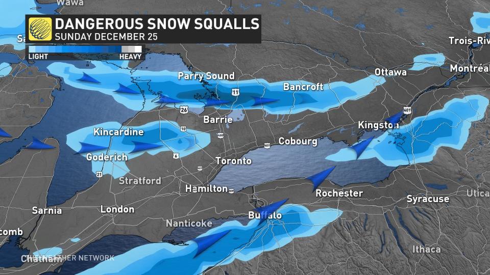
Check the forecast if you plan to travel on Christmas Day to see if there is any chance of encountering snow squalls that will continue through the day, but slowly start to wind down into Boxing Day.
WATCH: Your questions about holiday storm answered by our meteorologists
Thumbnail courtesy of Unsplash.
Check back for the latest on the forecast across southern Ontario.

