
Forecasters eyeing severe weather setup on eastern Prairies Sunday
The first weekend of the meteorological summer could see a stormy finish for parts of the Prairies.
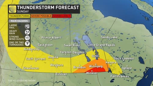
Conditions will be suitable for thunderstorms on Sunday across southern sections of the eastern Prairies and parts of northeastern Ontario. Some of the thunderstorms in this region could turn severe.
SUMMER 2024: Get an in-depth look at the Summer Forecast, tips to plan for it, and much more!
Severe storms could produce strong wind gusts, large hail, and locally heavy rainfall. While the risk is low and timing is brief, there is a potential for rotating storms and one or two tornadoes in parts of southern Manitoba.
It's always important to keep an eye on the sky and pay attention for any watches and warnings that are issued. Conditions can change quickly when severe weather hits.
Sunday: Severe storm risk for the eastern Prairies
A batch of moisture and instability will surge into Manitoba on Sunday as a stateside low-pressure system approaches the international border.

We’ll likely see thunderstorms develop during the early afternoon hours as a cold front pushes into that area of instability over southern Manitoba and far southeastern Saskatchewan. The risk includes Winnipeg, which experienced its 14th-rainiest May on record. It recorded almost 115 mm of rainfall.
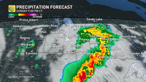
Additional thunderstorms are expected during the evening hours as the cold front arrives and provides extra lift.
The predominant threat with Sunday’s strongest storms will be strong wind gusts, large hail, and heavy rainfall that could lead to localized flooding.
MUST SEE: How severe weather alerts are issued, and potentially save lives
As well, warm front just south of the border may serve as a focus for stronger thunderstorms. It’s possible that some of these storms could rotate and lead to a tornado risk, but it is low and will be brief before the cells merge into a line.
Storms aren’t expected to remain organized across northwestern Ontario, and will fizzle into Sunday evening.
Unsettled start to June
Looking ahead, a centre of low pressure will redevelop east of the Rockies late Monday and track east across the region through the middle of the week.
This will bring more widespread rain, thunderstorms and windy conditions to the region, but southern Alberta and Saskatchewan are expected to miss out on the heaviest rain totals.
A much warmer and drier pattern is expected to develop across Alberta and into Saskatchewan starting next weekend and continuing through the following week. However, pulses of colder weather are likely for the eastern Prairies.
Be sure to check back for your latest forecasts across the Prairies.

