
Chances for light, slushy snow accumulation in Kentucky possible heading into the weekend
Kentucky could see snow accumulation this weekend, and the city of Lexington said crews were pretreating roads Friday in anticipation of that.
The city said crews from the divisions of Water Quality and Streets & Roads were using salt brine and Beet Heet to pretreat ”priority areas,” according to a news release.
The Transportation Cabinet’s District 7, which covers Central Kentucky, said it had workers on standby who would “report for duty as necessary to patrol and treat roadways. Motorists are advised to be on alert for possible hazardous driving conditions,” a news release stated.
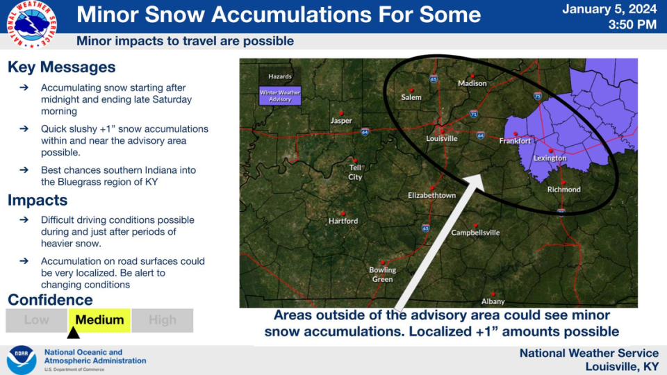
The National Weather Service in Louisville issued a winter weather advisory Friday afternoon for Fayette, Franklin, Scott, Harrison, Woodford, Bourbon, Nicholas, Jessamine and Clark counties from 3 a.m. until 1 p.m. Saturday.
The weather service said “rain is expected to change to wet snow” late Friday night, “with localized heavier bands of snow.”
About an inch of snow could accumulate on grass, with more snow possible in some places, according to the weather service.
Quick, slushy snow accumulations could create difficult driving conditions.
The weather service said the roads would likely be slick until about midday Saturday.
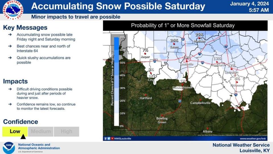
Quick slushy snow accumulations possible late Fri night into Sat morning, mainly along and north of I-64. Difficult driving conditions possible at times. pic.twitter.com/zfZOLNwaXD
— NWS Louisville (@NWSLouisville) January 4, 2024
The NWS said light rain is possible for Saturday night and Sunday.
WKYT Chief Meteorologist Chris Bailey described the forecasted storm as a quick-hitting wet snowfall. He expected a large area of the state to go under a winter weather advisory Friday night into Saturday morning.
The new future radar from the Hi Res NAM seems to have a decent handle on things. This is from 7pm Friday-7am Saturday and shows best snow in the Bluegrass Region into northern/northeastern Kentucky. Areas of a mix and some freezing rain in the valleys of eastern Ky. #kywx pic.twitter.com/NJ1BVJ7yZE
— Chris Bailey️ (@Kentuckyweather) January 4, 2024
Bailey also highlighted a storm trailing behind the incoming system, which possibly includes high winds, a wintry mix, heavy rain and chances for a quick freeze up.
“Widespread soaking rains and gusty winds are likely Tuesday with an even stronger storm system,” the weather service said Friday. “Wind gusts in excess of 40 mph will be possible. Snow may also be possible with this system, but confidence in its potential remains low.”
