
Winter shows its face in Ontario with noticeable cooldown and more snow
Southern Ontario will see more signs this week that winter has not disappeared after an odd, warm-at-times December that made many wonder where the cold and snow was.
The first week of January will bring the snow and chill, of which, the latter hasn't been truly felt in the region this season so far. Wind chills will make an appearance, dipping into the minus double digits. Make sure to dress appropriately if you're going outside for even a short amount of time on Thursday.
SEE ALSO: Where did December go? Canada's winter wonderland turned upside down
We will also see more snow, courtesy of a weak system and the lake-effect machine turning back on once more.
The first signs of snowfall will begin late Tuesday in cottage country and off of Lake Erie as a weak cold front moves through the region.

Folks waking up Wednesday morning may not notice much snow, as accumulations will be light, but as lake-effect bands intensify in the afternoon accumulations will increase. Areas east of Georgian Bay, Parry Sound, MacTier and Pointe au Baril will all see persistent snow through the day in the heaviest snow bands.
Along the Lake Huron shorelines, Grey Bruce will also see accumulating snow with the cold front and even some weak squalls off the lake.
DON'T MISS: El Niño reshapes winter landscape: Low ice coverage in Hudson Bay
The same will go for parts of Niagara as a lake-effect snow band will set up off Lake Erie, mostly impacting Buffalo, N.Y. There is the chance for snow to accumulate in Fort Erie and even Port Colborne as the squall will meander through the day.
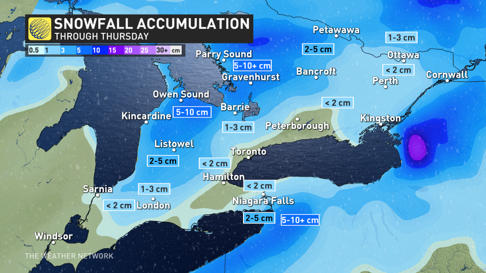
Cottage country, including Owen Sound, appears to have the highest chance for 5-10+ cm of snow, with a few flurries affecting the Highway 401 corridor and Hamilton.
Niagara Falls and the shores of Lake Erie should prepare for 3-5+cm of snowfall. Here, there is a risk for higher snowfall, depending on wind direction and where the lake-effect snow develops. Some models keep it stateside, but others push north into Canada. Be aware of possible snowy driving and delays at the border crossings.
Thursday
Thursday will see conditions improve but don't let the much-needed sunshine fool you. Wind chills will be quite uncomfortable, with minus double-digit, feels-like values spreading across the Greater Toronto Area (GTA) and east.
Wind chill values of -10 to -15 will be the warmest it gets on Thursday afternoon.

While the colder weather does not appear to stick around for long, it will be feeling much colder than temperatures felt in December. It's time to dust off the hats, mitts and warmer coats for one day.
Stay with The Weather Network for more forecast information and updates on your weather across southern Ontario.

