
Clock ticking towards Greater Toronto and Hamilton Area's first major snowfall
As we inch closer to the start of winter next month, meteorological and astronomical, eventually we will see the first major snowfall event in the Greater Toronto and Hamilton Area (GTHA). But, when will that occur?
While we've had snow in parts of southern Ontario earlier this month and on Halloween, we've yet to see a major, accumulating event for the GTHA. So, it can't be too far off in the future, right? Or is it farther off than we might think?
SEE ALSO: Snowvember? When Canada saw notable wintry weather ahead of schedule
Right off the bat, we can rule this week out. Temperatures will be on the mild side for a good portion of it. Let's just get that out of the way. You can partly thank B.C.'s impactful fall storm for that and the placement of the polar and Pacific jet streams, with a likely El Niño connection.
However, November is notorious for producing major, memorable snowfalls in many areas in southern Ontario. Typically, the snowbelt regions will see a wallop before the GTA does because of the lake-effect. You just have to go back one year to see a perfect example of that.
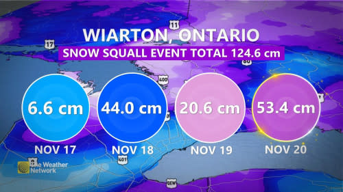
Powerful snow squalls targeted several areas of southern Ontario in 2022, with Wiarton, Ont., among the regions that got buried in 100+ cm of snow. The aforementioned community racked up an impressive total of 124.6 cm of snow over four days, of which, 53.4 cm piled up on Nov. 20 alone.
The event took place over several days from Nov. 17-21, so that timeframe is just around the corner.
But, another notable event in southern Ontario occurred around that same period in 2020, with impacts to the GTHA. On Nov. 22, many communities saw 15-25 cm of snowfall as their first significant event of the season.
Now, that particular affair was more impactful for the GTHA, with Toronto's Pearson International Airport recording a new, daily snow record for Nov. 22 with 19 cm documented.
Hamilton, Ont., saw a bit of accumulation from the storm, but not as much as Toronto. It documented 7 cm of snowfall during that event.
On Nov. 11, 2019, Hamilton saw 17 cm of snow fall. Toronto saw 13.6 cm of snow on Remembrance Day, with 13 cm of accumulation on the ground on the next day.
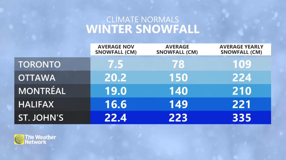
When it comes to average November snowfall, Toronto and Hamilton airports receive 9 and 11 cm, respectively.
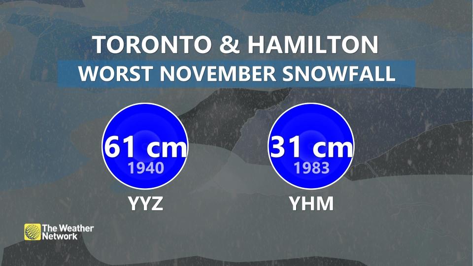
In terms of the worst November snowfall amounts, Toronto and Hamilton airports recorded 61 and 31 cm, respectively, in 1940 and 1983, respectively.
What the long-range pattern says
Over the next week, North America will experience an influx of Pacific air, but there are indications that temperatures will return to seasonal norms later in the month.
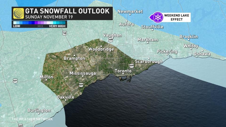
While it's not a significant threat, there will be a chance of a lake-effect snow setup this weekend, hovering around the GTHA on Sunday, Nov. 19. If the snow makes it into the region, accumulations aren't expected to be much.
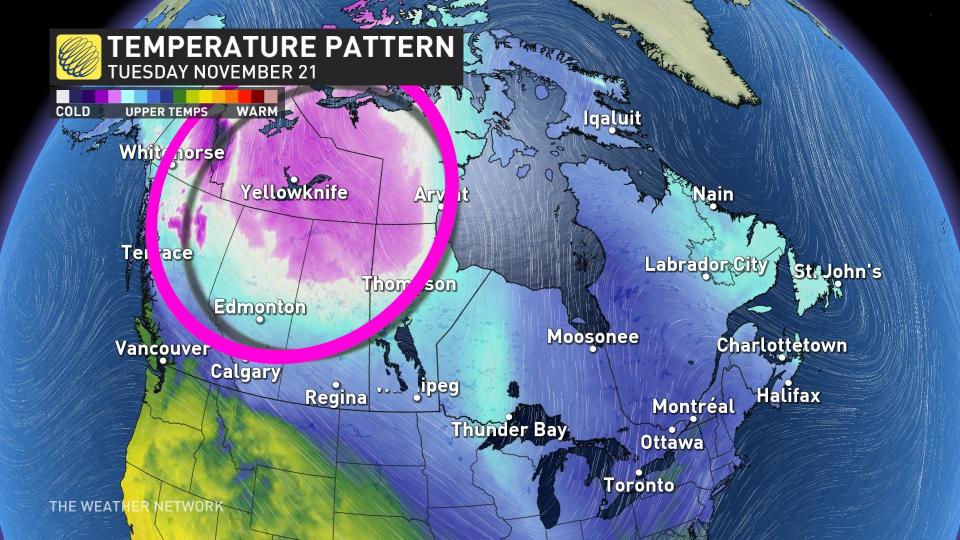
And, as we approach the end of November, one significant factor to keep an eye on is the Siberian air that may be redirected into Western Canada. Initially, this air will hover over the West, but it will attempt to shift eastwards. While this may not appear significant, falling temperatures could result in some locations in Ontario struggling to reach highs above the freezing point.
Although the storm track may be too far north to produce snow across the GTHA, initially, there is still a chance of winter weather towards the end of the month.
So, keep your winter clothing and snow-clearing equipment handy, just in case.
Thumbnail courtesy of Getty Images.

